This is 1 of 12 EarthCache sights in the SRWT. The first 100 to complete the trail will receive a geocoin commerating the SRWT, 60 of which are trackable. These will be available at the Mercer County Conservation District office Mon.- Fri. from 8 am to 4 pm after April 21st. We are located at 753 Greenville Road, Mercer, PA 16137. To learn more about this geoWatershed Trail, visit us by clicking here.
SHENANGO RIVER HISTORY (Mondok, 1990)
The Shenango River Basin is shared by the state of Ohio and the Commonwealth of Pennsylvania. The river and its tributaries drain 744 square miles of the Pennsylvania counties of Crawford, Lawrence, and Mercer and 285 square miles of the Ohio counties of Ashtabula , Mahoning, and Trumbull. The waters and its tributaries been used for transportation such as the Erie Extension Canal, watering livestock, and other household uses.
Prior to European settlement, the land area of the Shenango was inhabited by many indian tribes including the Seneca and the Delaware. The word Shenango itself comes from the Iroquoian word Shaningo meaning “beautiful one”.
The 75 mile long river begins in the marshes that are now part of Pymatuning Reservoir near Hartstown in Crawford County and eventually meets the Mahoning River near New Castle in Lawrence County.
ICE AGE INFLUENCES (Mondok, 1990)
The topography and soils in Pennsylvania and Ohio were shaped during the Ice Age that ended about 10, 000 years ago. Prior to this glacial epoch, the Shenango River flowed in a northerly direction to the Atlantic Ocean via the Great Lakes and St. Lawrence River. This dissected plateau was covered by glaciers; some were a mile thick in some places. Boulders, rocks, soil, sand, silt, and clay were carried with the glacial ice and deposited on glacial till, kame terraces, moraines, and eskers when the ice melts as the climate warmed. These deposits were so vast, that their ancient river valleys were filled, causing the flow from the Atlantic Ocean to the Gulf of Mexico.
ESKERS
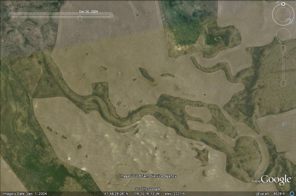
This image portrays what a general esker looks like. It appears to wind almost like a snake revealing the path of the glacial stream from long ago.
Eskers are among some of the most interesting kinds of glacial deposits. These were deposited by streams and rivers that flowed on top of glaciers, in the glacial cracks, or in some cases, even in tunnels beneath the ice. Take a step back in time and imagine a river that is flowing in a valley or crack of the glacier. What are the streambanks made up of? Ice of course. These Ice Age rivers and streams deposited gravel and sand in their ice valleys, just as modern streams deposit sediments in their valleys and streambeds. The key difference between modern day rivers and streams compared to the glacial streams and rivers is their streambanks. Unlike present day streambanks, the glacial streambanks of those esker rivers eventually melted away, thus leaving gravel deposits standing as ridges. What a topographical phenomenon! The once valleys became inverted into present-day ridges. To put it simply, eskers are the ridges of gravel and sand that mark the routes of stream and rivers that flowed in, on, or beneath glaciers. The word esker comes from an Irish Gaelic work “eiscer” which means ridge. These remnant glacial features can be more than 100 feet high, a few hundred feet wide, and many miles long. Some eskers have almost nearly level crests (Bluemle, J.P., 2007).
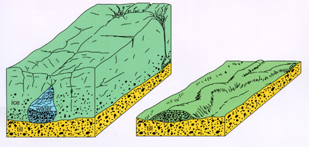
The image to the left displays an esker river that is flowing within a glacier. The image to the right displays what is left behind from the esker river as the glacier melted away and disappeared.
SHENANGO TOWNSHIP ESKER
The Shenango Township Esker is thus a unique geological feature from glacial periods. It displays where the glacier once was and the esker stream or river that flowed on, in, or beneath it. This esker is not as prominently noticeable as ones that are covered with low vegetation such as grasses; the trees tend to mask its topography and make it appear as just another small hill. Take a close look and you can see how the ridge tends to wind along the valley floor. What an interesting glacial phenomenon!
COORDINATES TO PARKING AREA
The coordinates listed below, give you a view of the esker itself. This is a better way to view the esker than on it itself because you can see the elevation differences from this location. It may be harder to see the esker depending on the time of year due to its lush vegetation. The esker itself is located to the northeast/ east from this location.
N 41 08.146’ W080 30.395’
TO GET CREDIT FOR THIS CACHE:
Please be sure to send your answers to the following questions to jmccullough@mcc.co.mercer.pa.us in order to receive credit for this cache. To be able to answer these questions, you will need to travel to Stony Hill Road to determine the elevations at the bottom and top of the esker off of the road. The coordinates for the beginning of the road are: N41 8.324’, W080 30.366’.
1. What is the elevation at the base of the esker?
2. What is the elevation at the top of the esker (the highest point on Stony Hill Road)?
3. What is the elevation difference?
4. As you drive up Stony Hill Road, you will notice rocks to your right and left as you ascend the esker. Do you think these rocks are glacial debris deposits? Why or why not? Describe the shape of the rocks to reinforce your reasoning.
References:
Bluemle, J.P. (2007). Eskers in North Dakota. North Dakota Geological Survey. Retrieved from: https://www.dmr.nd.gov/ndgs/ndnotes/Eskers/Eskers.asp
Mondok, J. (1990). The Shenango River. Shenango Riverscapes, 1-2.