This is 1 of 12 EarthCache sights in the SRWT. The first 100 to complete the trail will receive a geocoin commerating the SRWT, 60 of which are trackable. These will be available at the Mercer County Conservation District office Mon.- Fri. from 8 am to 4 pm after April 21st. We are located at 753 Greenville Road, Mercer, PA 16137. To learn more about this geoWatershed Trail, visit us by clicking here.
SHENANGO RIVER HISTORY (Mondok, 1990)
The Shenango River Basin is shared by the state of Ohio and the Commonwealth of Pennsylvania. The river and its tributaries drain 744 square miles of the Pennsylvania counties of Crawford, Lawrence, and Mercer and 285 square miles of the Ohio counties of Ashtabula , Mahoning, and Trumbull. The waters and its tributaries been used for transportation such as the Erie Extension Canal, watering livestock, and other household uses.
Prior to European settlement, the land area of the Shenango was inhabited by many indian tribes including the Seneca and the Delaware. The word Shenango itself comes from the Iroquoian word Shaningo meaning “beautiful one”.
The 75 mile long river begins in the marshes that are now part of Pymatuning Reservoir near Hartstown in Crawford County and eventually meets the Mahoning River near New Castle in Lawrence County.
ICE AGE INFLUENCES (Mondok, 1990)
The topography and soils in Pennsylvania and Ohio were shaped during the Ice Age that ended about 10, 000 years ago. Prior to this glacial epoch, the Shenango River flowed in a northerly direction to the Atlantic Ocean via the Great Lakes and St. Lawrence River. This dissected plateau was covered by glaciers; some were a mile thick in some places. Boulders, rocks, soil, sand, silt, and clay were carried with the glacial ice and deposited on glacial till, kame terraces, moraines, and eskers when the ice melts as the climate warmed. These deposits were so vast, that their ancient river valleys were filled, causing the flow from the Atlantic Ocean to the Gulf of Mexico.
ARTESIAN WELL BASICS
Artesian wells are “pumpless” wells; in other words, water courses through porous rock in an astounding feat of defying gravity. This is possible because the pressure that accumulates between the impermeable rock layers. In an effort to relieve the pressure and equilibrium, the porous rock pushes up the water, which eventually reaches the open air where the pressure is relieved (Brainz, 2010).
The water source for artesian wells is known as an aquifer. These aquifers store water in permeable rock such as limestone or sandstone that comes from melting snow, high precipitation, groundwater, run-off, etc. As stated previously, this permeable stone is surrounded by two layers of impermeable stone like clay or rock. This impermeable rock is what causes the high levels of pressure that eventually push the water to the surface through either some sort of man-made piping or a fracture in the impermeable rock (Brainz, 2010).
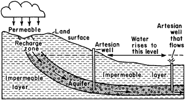
This pictures the basic artesian well. If the water table is above the artesian well outsource, the water flows freely. If the water table drops below the artesian well outsource, the water flow may stop temporarily.
For thousands of generations, people have relied on these artesian wells for water. Unlike traditional wells, these wells provide water that is cold and clean. The permeable rock acts as natural filters and percolators that trap contaminants as the water passes through it. It is said that water from artesian wells is much safer than river water. As stated previously, people usually install piping into the ground until it reaches the aquifer trapped between the impermeable rocks. This allows an outlet for the water to pump to the surface. In ancient times, people would access these wells by hitting a rod with a sharpened tip with a hammer (Brainz, 2010).
COORDINATES TO PARKING AREA
The parking location is the same as the EarthCache sight. This is located alongside a dirt road.
TO GET CREDIT FOR THIS CACHE:
Please be sure to send your answers to the following questions to jmccullough@mcc.co.mercer.pa.us in order to receive credit for this cache.
1. What did humans insert into this aquifer that allowed the artesian well to flow?
2. Water from artesian wells is said to be cleaner than river water. What plant species appears to be growing in the area that the water is flowing into?
References:
Brainz. (2010). What is an Artesian Well? Retrieved from: http://brainz.org/what-artesian-well/
Mondok, J. (1990). The Shenango River. Shenango Riverscapes, 1-2.