This is 1 of 12 EarthCache sights in the SRWT. The first 100 to complete the trail will receive a geocoin commerating the SRWT, 60 of which are trackable. These will be available at the Mercer County Conservation District office Mon.- Fri. from 8 am to 4 pm after April 21st. We are located at 753 Greenville Road, Mercer, PA 16137. To learn more about this geoWatershed Trail, visit us by clicking here.
SHENANGO RIVER HISTORY (Mondok, 1990)
The Shenango River Basin is shared by the state of Ohio and the Commonwealth of Pennsylvania. The river and its tributaries drain 744 square miles of the Pennsylvania counties of Crawford, Lawrence, and Mercer and 285 square miles of the Ohio counties of Ashtabula , Mahoning, and Trumbull. The waters and its tributaries been used for transportation such as the Erie Extension Canal, watering livestock, and other household uses.
Prior to European settlement, the land area of the Shenango was inhabited by many indian tribes including the Seneca and the Delaware. The word Shenango itself comes from the Iroquoian word Shaningo meaning “beautiful one”.
The 75 mile long river begins in the marshes that are now part of Pymatuning Reservoir near Hartstown in Crawford County and eventually meets the Mahoning River near New Castle in Lawrence County.
ICE AGE INFLUENCES (Mondok, 1990)
The topography and soils in Pennsylvania and Ohio were shaped during the Ice Age that ended about 10, 000 years ago. Prior to this glacial epoch, the Shenango River flowed in a northerly direction to the Atlantic Ocean via the Great Lakes and St. Lawrence River. This dissected plateau was covered by glaciers; some were a mile thick in some places. Boulders, rocks, soil, sand, silt, and clay were carried with the glacial ice and deposited on glacial till, kame terraces, moraines, and eskers when the ice melts as the climate warmed. These deposits were so vast, that their ancient river valleys were filled, causing the flow from the Atlantic Ocean to the Gulf of Mexico.
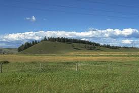
MCGUFFEY DRUMLIN
Located on McGuffey Road in Mahoning County, Ohio is a low, smoothly-rounded hill approximately 800 feet long, 200 feet wide and 40 feet high. Based on observations of the makeup of the hill during excavations over the years and the fact that the elongated hill has the general shape of a teaspoon lying upside down, the hill is a drumlin.
A drumlin (the word drumlin is derived from the Gaelic word druim, a “rounded hill” or “mound”) is an oval or elongated hill made under the ice of a glacier when a crevice in the ice has allowed till, gravels and rock to fall to the bottom of the glacier. This unsorted material, deposited by the glacial ice, shows no stratification. Generally found in broad lowland areas, the long axes of drumlins roughly run parallel to the path of glacial flow. Although the shapes of drumlins vary, the glacier side of a drumlin is always high and steep, with the opposite end smooth and tapering gently in the direction of the ice movement (Allaby, M. 2004).
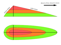
This image portrays the glacial side of the drumlin, the steep, high side, as well as the smooth tapering side that displays the direction of ice movement.
According to John Hildreth Chase in his book, Geological Field Trips in the Youngstown Area, a 1941 excavation found the hill on McGuffey Road “to be made of a jumble of sand, pebbles and boulders” with “no stratification”. He also stated that the axis of the drumlin “lies 30 degrees west of north which is the usual direction of glacial scratches in the Youngstown area”.
Drumlins are common in central Wisconsin, central New York, northwestern Canada, southwestern Nova Scotia, and in Ireland. However, Chase believed that the drumlin on McGuffey road is the only one discovered in Ohio.
This picture displays what a general drumlin looks like.
McGUFFEY WILDLIFE PRESERVE
This Earth Cache is located at McGuffey Wildlife Preserve, one of eight preservation areas in the 4,400-arce Mill Creek MetroParks system in Mahoning County, Ohio. Mill Creek Park, which was established in 1891 as the first park district in Ohio, was converted to a metropolitan park district in 1989 (Mill Creek MetroParks, 2011).
The 78-acre McGuffey Wildlife Preserve was donated to Mill Creek Park in 1998 by the William Holmes McGuffey Historical Society. Once the former home of William Holmes McGuffey, author of the McGuffey Readers, who lived in a log cabin on this site; the William Holmes McGuffey Boyhood Home Site was designated a Registered National Historic Landmark (Mill Creek MetroParks, 2011).
COORDINATES TO PARKING AREA
N41 7.155' W080 33.505'
TO GET CREDIT FOR THIS CACHE:
Please be sure to send your answers to the following questions to jmccullough@mcc.co.mercer.pa.us in order to receive credit for this cache.
1. What is the elevation at the top (highest point) of the drumlin?
2. What is the elevation at the base of the drumlin?
3. What is the elevation difference between the top and bottom of the drumlin?
4. In which direction does the ice appeared to have flowed based off of the drumlin formation?
A special thank you to the Mill Creek MetroParks for granting permission to place this EarthCache.
References:
Allaby, M. (2004). A Dictionary of Ecology. Encyclopedia.com Retrieved from: http://www.encyclopedia.com
Chase, J.H. (1943). Geological Field Trips in the Youngstown Area, A Story of the Foundation Stones of Our City, 1-3.
Mill Creek MetroParks. (2011). McGuffey Wildlife Preserve. Retrieved from: http://www.millcreekmetroparks.com/ParksFacilities/NaturePreserves/McGuffeyWildlifePreserve/tabid/1515/Default.aspx
Mondok, J. (1990). The Shenango River. Shenango Riverscapes, 1-2.