Ilfelder Porphyrit - Blick ins Innere eines Vulkans
Ilfeld Basin - Looking into the Interior of a Volcano
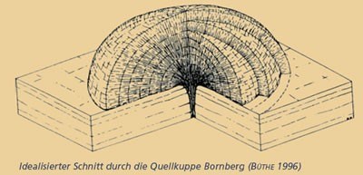
Der ehemalige Gemeindesteinbruch befindet sich am nordöstlichen Ortsrand des Ortsteils Osterode der Gemeinde Neustadt/Harz in der geologischen Einheit "Ilfelder Becken". Dieses bildet mit einer Fläche von ca. 120 km2 das größte Rotliegend-Vorkommen des Harzes und ist im Raum Ilfeld - Neustadt durch eine mächtige rhyolitische Vulkanitserie gekennzeichnet. Dieser in der älteren Literatur als "Ilfelder Porphyrit" bezeichnete Vulkanitkomplex ist auf einer Fläche von ca. 50 km2 verbreitet. Zugehörige Vulkanschlote bzw. Lavaförderzentren sind jedoch nur sehr wenige bekannt. Im Aufschluss am Bornberg ist ein Lavaförderzentrum in Form einer in idealer Gefügeanordnung ausgebildeten Quellkuppe aufgeschlossen.
This former municipal quarry is located in the north eastern edge of the Osterode district of the municipality of Neustadt/ Harz and belongs to the geological structure designated as the “Ilfeld Basin”. The basin represents the largest occurrence of the Rotliegend formation in the Harz and covers an area of about 120 km2. In the area of Ilfeld – Neustadt, it is characterized by thick ryolitic volcanic sequences. This volcanic complex, called the “Ilfeld Porphyrit” in earlier literature, extends over an area of 50 km2. There are, however, very few volcanic vents and centres of lava production normally associated with such a complex to be found here. The exposure at the Bornberg represents a center of lava production which developed as a cupola of stagnation with ideal structural configuration.
Quelle: www.harzregion.de
Hier ist rhyolitische Lava in bereits vorher abgelagerte, aber noch nicht verfestigte Aschestromablagerungen eingedrungen und hat in mehreren Schüben eine domartige Struktur gebildet. Auf Grund seiner an diesem Standort gegebenen Festigkeit ist das vulkanische Gestein, der Rhyolith ("Ilfelder Porphyrit"), hier abgebaut worden, wodurch die innere Struktur der vulkanischen Quellkuppe sichtbar wurde und in sehr anschaulicher Weise die Fördertätigkeit des Rotliegend-Vulkanismus deutlich wird.
Here, the ryolitic lava penetrated previously deposited but not yet lithified ash flow sediments, and formed, in the course of several phases, a dome-like structure. Because of its specific hardness, the volcanic rock designated as ryolite (“Ilfeld Porphyrit”) was excavated at this site. As a result, the exposed inner structure of the cupola of stagnation was gradually rendered visible, yielding vivid impressions of the flow activity in the course of the Rotliegend volcanism.
Quelle: www.harzregion.de
Lava ist die Bezeichnung für eruptiertes Magma das an die Erdoberfläche ausgetreten ist. Lava ist ein vulkanisches Förderprodukt. Magmen treten vergleichsweise selten direkt an die Oberfläche aus da dazu erhebliche Kräfte erforderlich sind. Häufiger sind so genannte Intrusionen bei denen Magma in der Erdkruste erstarrt.
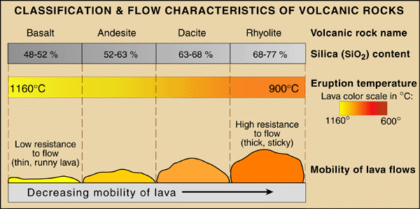
Laven sind Silikatschmelzen mit einem Gewichtsanteil von 45%-70% SiO2. Man unterscheidet zwischen saurer oder rhyolitischer Lava (SiO2-Gehalt > 65%), wie bei unserem hier vorliegenden Vulkan und basischer oder basaltischer Lava (SiO2 -Gehalt < 52%).
Beim Aufstieg des Magmas finden verschiedene Prozesse statt die Einfluss auf die Zusammensetzung der austretenden Lava haben (Magmatische Differentiation) so dass diese von der des primären Magmas abweichen kann. Da Lava beim Austritt an die Oberfläche schnell abkühlt ist ihr Gefüge in der Regel feinkörnig oder glasig. Durch den Austritt von Gasen durch die Druckentlastung beim Aufstieg können sich in der Lava kleinere oder größere Blasen bilden. Die Temperatur von Lava beträgt beim Austritt zwischen 800 °C (rhyolitische Lava) und 1200 °C (basaltische Lava). Erstarrte Lava bildet magmatisches Gestein.
Abhängig von den Bedingungen beim Aufstieg und der Abkühlung bildet Lava unterschiedliche Erscheinungsformen die ganz entscheidend von der Viskosität der Lava abhängen.
Lava is the term for magma erupted leaked to the surface. Lava is a volcanic conveyor product. Magmas occur relatively rarely directly to the surface because of this, considerable forces are required. Frequent intrusions which are known as magma solidifies in the crust.
Lavas are molten silicate having a weight fraction of 45% -70% SiO2. We distinguish between rhyolitic lava or acid (SiO2 content> 65%), as in our present and basic volcanic or basaltic lava (SiO2 content <52%).
In the ascent of the magma may have different processes take place that influence the composition of the emitted lava (igneous differentiation) so that they may differ from that of the primary magma. As the lava cools quickly escape to the surface structure it is usually fine-grained or glassy. By the escape of gases through the pressure relief during the ascent of the lava can form in small or large bubbles. The temperature at the exit of lava is between 800 ° C (rhyolitic lava) and 1200 ° C (basaltic lava). Solidified lava forms igneous rock.
Depending on the conditions during the ascent and cooling of the lava forming different forms that depend crucially on the viscosity of the lava.
Quelle: www.scienceviews.com
Kryptovulkanismus, auch Subvulkanismus genannt, ist eine Form des Vulkanismus, der sich zwischen dem Oberflächenvulkanismus und dem Tiefenvulkanismus abspielt. Das aufsteigende Magma erstarrt noch innerhalb der Erdkruste, aber nahe der Erdoberfläche, und bildet dabei vulkanische Gesteine oder bei größerer Erstarrungstiefe durch die längere Abkühlungsdauer Ganggesteine.
Beim Aufstieg nutzt das Magma vorhandene Spalten und Hohlräume der Erdkruste, und erweitert diese durch Aufschmelzung oder Verdrängung von Nebengestein. Erreicht es die Erdoberfläche, so kommt es zu Vulkanausbrüchen, und es fließt als Lava aus. In manchen Fällen bleibt das aufdrängende Magma jedoch stecken, etwa aufgrund seiner Zähigkeit oder aufgrund eines Zusammenwirkens von Abkühlung und Ausbleiben des Nachschubs. Je nach geologischer Situation entstehen so subvulkanische Intrusivkörper der unterschiedlichsten Formen.
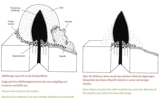
Das Magma kann dabei keulenartig aufdringen und die überlagernden Schichten beulen- oder domartig aufwölben, dann entsteht ein Kryptodom.
Beim Kryptodom, in Deutschland auch Quellkuppe genannt, bildete das aufsteigende zähflüssige Magma keulen- oder kugelförmige Gesteinskörper innerhalb der weichen Deckschicht (meist aus Tuff), die es zwar domartig aufwölben, nicht aber durchbrechen konnte. Typisch für Quellkuppen sind intermediäre oder felsische vulkanische Gesteine wie Trachyt, Latit, Phonolith oder wie in unseren Fällen Rhyolith.
Kryptovolkanism, also called Subvolkanism, is a form of volcanic activity that takes place between the surfacevolkanism and deepvolkanism. The rising magma solidifies within the earth's crust, but close to the earth's surface, forming volcanic rocks, or with greater depth of freezing due to the longer duration of cooling dykes.
When the magma ascent utilizes existing cracks and cavities in the earth's crust, and extends it by melting or displacement of surrounding rock. It reaches the earth's surface, so it comes to volcanic eruptions, and it flows out as lava. In some cases, the intruding magma, however, stuck, perhaps because of its toughness, or due to an interaction of cooling and lack of supplies. Depending on the geological situation as subvolcanic intrusive bodies of various shapes arise.
The magma can intrude club-like and the overlying layers bulge or dome-like bulge, then creates a Crypto.
The Crypto in Germany called the source peak, rising viscous magma formed the club-shaped or spherical bodies within the soft layer of rock (mostly tuff), the bulge is indeed like a dome, but could not break through. Typical of spring cones are intermediate or cliff volcanic rocks such as trachyte, Latit, phonolite or rhyolite as in our cases.
Das Ilfelder Porphyrit weißt eine spezielle Eigenart auf. Dieser weist eine lokal sehr unterschiedliche Festigkeit und Verwitterungsresistenz auf. Teilweise ist das Gestein sehr weich und mürbe und zerfällt unter Witterungseinflüssen in relativ kurzer Zeit in kleinste Bestandteile. In unmittelbarer Nachbarschaft dagegen weist das gleiche Gestein eine hohe Festigkeit und Beständigkeit auf. Dadurch entstanden im Behretal zahlreiche bizarre Felsgebilde mit Formen, welche die Phantasie der Menschen anregten.
The Ilfelder Porphyrit know a special character. This has a very different local resistance and weathering resistance. Some of the rock is very soft and crumbly and falls apart under the weather in a relatively short time into minute pieces. In the immediate neighborhood on the other hand has the same rock on a high strength and durability. This resulted in a number of bizarre rock formations with Behretal forms, which stimulated the imagination of the people.
Quellen / sources: wikipedia.org; Infotafeln vor Ort; Karstwanderweg.de; harzregion.de; geopark-harz.de; scienceviews.com; http://www.harzlife.de/kurios/nadeloehr.html
Begebt euch an die angegebenen Koordinaten und beantwortet die folgenden Fragen anhand der Hinweisschilder.
Ihr dürft gleich loggen, wenn es Probleme gibt dann melden wir uns.
Schön wäre es, wenn ihr auch ein Bild von euch / eurem GPS und der Landschaft im Hintergrund hochladen würdet.
Fragen:
1. In welchem Zeitfenster entstand die Quellkuppe?
2. Beschreibe das hier aufgeschlossene Porphyrit (Farbe, Oberflächenstruktur)!
3. Nenne neben dem Gänseschnabel zwei weitere Naturdenkmäler aus freistehendem Porphyrit!
At the coordinates you will find informations board. To log this cache, answer the following questions and email us your answers.
If you want you can take a picture of you and your GPS device at the coordinates and upload it with the log.
You can log immediately. If there are any problems, we will send you a message.
Questions:
1. In what time frame was the source tip?
2. Describe the here open-minded porphyrite (color, texture)!
3. Call two more natural monuments of freestanding porphyrite next to the goose beaks!
Happy Hunting wünschen