(SI) Spomin na najmocnejsi znani potres na obmocju Slovenije! Poiscite objekte obnovljene po tem potresu in na njih zapise, ki so zabeležile unicenje in obnovo.
PRED ZACETKOM:
Opis tega Geološkega zaklada je dolg. Prosimo, preberite ga in si zapisite naloge za vpis se pred obiskom zaklada!
NALOGE ZA VPIS OBISKA
1. Sprehodite se ob objektih na Mestnem trgu. Poiščite vsaj objekte z oznako spomeniške zaščite na naslovih Mestni trg 2, 5, 8, 14, 15, 26, 35. Preberite kratke opise na tablicah. Izgled oznake kakršne iščete je prikazan v desnem zgornjem kotu karte mesta (slika 5). Na novih tablicah žal ni več zapisano, da so bile vse stavbe na navedenih naslovih zgrajene v 16. stoletju. Glede na te informacije razmislite kaj lahko rečete o obsegu škode, ki jo je povzročil potres 1511 v mestu.
2. Objekti porušeni v potresu 1511, seveda po 500 letih niso puščeni kot kupi ruševin sredi mesta! Vendar na sprehodu po predlaganih točkah poti lahko še vedno najdete posredne dokaze o potresu. Prosimo, opišite kaj ste odkrili.
3. Na spodnjem delu obodnih zidov gradu so graditelji pustili viden, neometan kamen. Oglejte si ga na točki wp6. Zakaj se graditelji, po vašem mnenju niso pretirano ukvarjali s sortiranjem kamnov pred vgradnjo?
Dodatno, neobvezno vprašanje: Ali lahko poveste katere vrste kamnin so uporabljene v zidu?
POMEMBNO!
- Preden vpisete obisk zaklada, posljite odgovore preko GC profila ali neposredno na e-naslov vane.si.geo@gmail.com. Takoj potem lahko vpisete obisk zaklada na spletu – ne potrebujete dodatnega dovoljenja. Ce ste fotografirali, prosimo, prilozite kaksno fotografijo.
- Vpisi brez ustrezne spremljajoce e-poste, ki vsebuje pravilne odgovore, bodo najprej trajno kodirani, kasneje izbrisani!
- Vpisi in fotografije ki vsebujejo ali razkrivajo odgovore bodo izbrisani!
(ENG) A memory of the strongest known earthquake in the region of Slovenia! Find buildings rebuilt after the earthquake and inscription-plates which recorded destruction and reconstruction.
BEFORE THE BEGINNING:
This EarthCache has a long description! Please, read it and write down logging tasks before visiting the EarthCache site!
LOGGING TASKS
1. Take a walk along the Mestni trg (Town square). Find buildings marked as Cultural property at addresses Mestni trg No. 2, 5, 8, 14, 15, 26, 35. Read short descriptions in English or Slovene there. Unfortunately, new glass plates don’t cite the age of houses – they have all been built in the early 16th century. What can you say about the extent of the damage caused by the 1511 earthquake considering this information?
2. Buildings destroyed by the earthquake in 1511 are, of course, not left in ruins there in the middle of the town after 500 years! Still, you can find indirect evidence about the earthquake during your walk along the waypoints. Please, describe what you have seen in few words.
3. There are un-plastered bottom parts of outer castle walls, with visible stone blocks. You can take a closer look at waypoint wp6. What do you think, why have builders not bothered with sorting out the stones first?
Additional question (you are not obliged to answer): Can you tell which types of stone have they used there?
IMPORTANT!
- Send answers through GC profile or directly to e-mail vane.si.geo@gmail.com
before logging. After that you can log - you don't need an additional permission to log. Please, upload photos if you have taken them.
- Logs without an accompanying e-mail containing correct answers will be encrypted and later deleted!
- Logs and photos containing or revealing answers will be deleted!
slovensko besedilo / Slovenian text
tocke poti in dnevniki / waypoints and logs
Visit our web-site Geološki zakladi / EarthCaches
for a complete list of our EarthCaches and a lot of additional information.
(ENG) WAR, PLAGUE, FAMINE, AND FISH FARONIKA TO TOP IT ALL!
Life has not been easy for our forebears in the western part of Slovenian territory and in the neighboring Friuli! Historians agree that many unfortunate events followed one another in these places in the year 1511. Habsburgs and Venetians have already been in war since 1508.
War has been just a part of series of sad events. An epidemic of plague broke out in 1510, followed by robbery and arson of different armed groups, especially in Friuli. Plague has been the worse in Friuli and Veneto. Famine has also taken many lives at this time. In Videm (Udine) the dead have been buried beside streets, because there has been no place left at graveyards.
As usual, ordinary, poor people have suffered the most because of all these misfortunes. And than, fish Faronika has awoken! According to peoples beliefs at that time, fish named Faronika, or a half-fish-half-girl creature has ruled in the see. And whenever she moved, Earth trembled or floods came... If Faronika should turn on her back or dive, her action has been sure to bring “the end of the world”... So, amidst all the trouble, Faronika started to move restlessly!
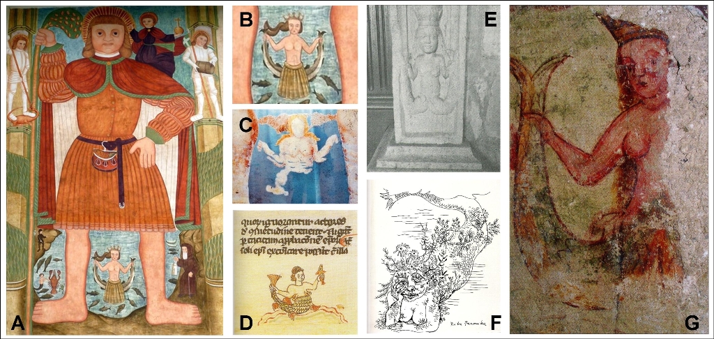
Figure 1: Fish Faronika, popular image from middle Age fairy tales is often painted on church walls (A, B, C, G), usually in the vicinity of St. Christopher, who supposedly protected people from her danger. Faronika appears in folk songs, different written texts (D – middle Age manuscript from Bistra), as carving in the stone (E). And it is still not forgotten, as modern drawings prove (F – France Mihelic, 1955); Reference No. 9.
EARTHQUAKE!
In the afternoon of March 26th 1511, one of the strongest earthquakes in this part of Europe has hit. Many of the consequences have been recorded by witnesses.
There is a hand-written letter in Bavarian state library in Munich, parts of which we cite: “At the day of 28th March, in the year of our Lord 1511, Jörg von Egkh, the imperial representative in Carniola, has written to Pavel von Liechtenstein: God has sent a terrible, horrible, unprecedented earthquake upon this land, which happened at March 26th, and many earthquakes followed during day and night, but became weaker. It has damaged and ruined buildings and towns, churches and other property...” Some days later, from April 7th to 14th, official notes, a correspondence of Carniola region assembly to the emperor Maximilian I., add some information: “A lot of grain and other food has been buried, and otherwise destroyed, especially in Karst region and Carniola. Not even 100.000 guldens can substitute the damage.”
At the last page of the book Sacra Biblia, which is stored in the National and University library in Ljubljana, a text is written by the owner or another reader, and describes earthquake as it has been observed in Ljubljana: “At March 26th, Wednesday, at 3 in the afternoon a mighty strong earthquake came in three shocks. It all lasted one hour (with intervals), than it came daily, (trembling) lasted some hours, in Friday, at 2 in the afternoon it has been strong again. Trembling has been strong enough to ruin the church of German Knightly Order (Krizanke) in Ljubljana and many other houses have collapsed...”
THE EPICENTER OF THE EARTHQUAKE
Some seismologists suggest an epicenter of 1511 earthquake in Friuli, Italy, and compare it with the 1976 Humin (Gemona del Friuli) earthquake which took 1000 lives. Others prefere the theory of epicenter at the Idrija fault.
The Idrija fault is morphologically most clearly expressed, over 120 km long fault zone of the western part of Slovenia. Its direction can be easily seen even from satellite images. Fault begins in Italy, runs in almost straight line from Zaga at river Soca, across Idrija, three karst poljes (Planina, Cerknica and Babno polje), and further to Croatia. It is still an active, dextral stike-slip fault today.
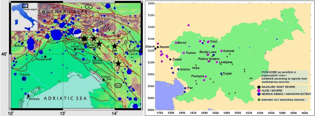
Figure 2a – Seismotectonic map of the eastern Alps region. Red lines represent faults, blue hexagons and circles indicate the epicenters of the earthquakes with MW ≥ 4.0 respectively before and after 1900, black stars show the epicenters of the 1511 earthquake according to (1) Ambraseys (1976), (2) and (3) Ribaric (1979), (4) Postpischl (1985), (5) Boschi et al. (2000), (6) CPTI Working Group (2004), and (7) Fitzko et al. (2005), the beach balls represent the focal mechanisms of the 1976 (Slejko et al., 1999) and 1998 (Zupancic et al., 2001) earthquakes; Reference No. 3.
Figure. 2b – Earthquake 1511 effects in Slovene teritory and in Cedad (Cividale) surroundings. Data for Italy and Austria are arranged according to Camassi et al., 2010. Damage is sorted according to extensiveness, and quality of available sources; Reference No. 1.
There are many theories about the epicenter of this earthquake. It has caused the worst damage in Friulian towns Cedad (Cividale del Friuli), Humin (Gemona del Friuli) and Osovk (Osoppo). It has been recorded far away from the epicenter too, all the way to the north of German lands and Bohemia. Even some damage of buildings in Venice, Zagreb and Vienna has been attributed to this earthquake. What is the truth or maybe misinterpretation of sources and erroneous conclusion is still researched by seismologists and historians. A map of all earthquake epicenters proposed so far (Figure 2a) has been made. After the studying of the available information about the intensity, they have found out, that it has been the highest in the surroundings of Cedad (Cividale del Friuli), but The area of high intensity, has been centered in Cedad (Cividale del Friuli), but also very prolonged towards west, and towards southeast and east. No such phenomena have been observed during recent earthquakes of 1976 and 1998! Opinion of the authors is that the event of 1511 could have been caused by displacements at the area where Southern Alps and Dinarides interconnect.
SHORT SUMMARY OF THE 1511 EARTHQUAKE DATA KNOWN TODAY
Epicenter: along the Idrija fault or somewhere close to this area, more locations are possible, from Idrija to Cedad (Cividale del Friuli);
Highest intensity: X. at European Macroseismic Scale (EMS-98), Friuli, Italy;
Magnitude: estimated at 6,8 to 6,9.
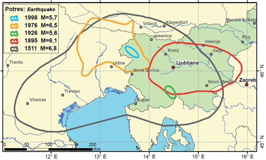
Figure 3: Izoseistes (lines limiting areas with the same earthquake intensity) of intensity VII according to The European Macroseismic Scale (EMS); Comparison of five strongest earthquakes in Slovenia region: 1511 (Idrija), 1895 (Ljubljana), 1926 (Cerknica), 1976 (Friuli) and 1998 (Upper Soca valley); cartography: M. Zivcic, P. Zupancic – Slovenian Environment Agency; Reference No. 6.
CONSEQUENCES OF THE EARTHQUAKE IN SLOVENIA
There are written reports from eyewitnesses about consequences of the earthquake for many towns: Tolmin, Bovec, Skofja Loka, Ljubljana, Radovljica, Polhov Gradec, Postojna, Celje, Cerknica and others. There are even more reports about ruin and damage of individual castles: Divja Loka (Wildenlack) near Skofja Loka, Hosperk (Haasberg) at Planina polje, Turjak, Gutenberg and Klanc (Glanz) near Trzic, Hudi grad above Bistrica, Bled, Neuburg near Preddvor, both castles in Kamnik, Prezek in Gorjanci, Stari grad (old castle) at Smlednik, Kamen, Duplje, Steberk and others. There were many churches destroyed and many other buildings too.
Idirja: Secondary sources about the damage are available only. Less than three years before earthquake, important discoveries of mercury have been made in Idrija and proper mining started. Mine shafts and stone-built buildings outside have been severely damaged in earthquake. Exact extent of damage is not known, but the reparation of the mine has lasted until 1517! Otherwise, majority of buildings in the town has been made of wood, except a chapel, church, and house of mine manager. Besides, Idrija has been struck by one more disaster – a large landslide occurred at Oblocnik under Stan, filled the Idrijca valley and caused flooding of entire mining town and the mine! The landslide location and deformation is still visible today. Landslide event is documented in the mine books, but not dated, therefore it is possible that landslide occurred later.
Skofja Loka: Earthquake damage is well documented. Memorial plates, engraved in stone, are built in the walls of the Skofja Loka castle and granary. In the chapel, inside the house of citizen Schwartz, an inscription on the wall has been found, describing earthquake and its consequences. Even thou town has suffered a substantial damage, Bishop Philip has managed to renew it in few years, and quick development followed. Many buildings from those times are still in use today.
Tolmin and Bovec: Historians have learned about the situation there from diaries of Marino Sanudo from Venice. He has carefully rewritten data from his extensive international correspondence. »According to eyewitnesses one has to presume that Bovec is completely demolished, important road across Predil pass is closed, because two hills have slided towards one another and closed this way to Germany... «. It has been reported that both castles have been destructed in Tolmin and guardians have deserted...
Ljubljana: Officials of Carniola region assembly had to leave their house, because it has been damaged too much to provide adequate shelter. Egkh has mentioned destruction of the house and church of German Knightly Order (Krizanke), his own palace and other well-built houses. He states that »... many other houses have been too cracked to be suitable to live in, so, people left the town and are waiting in the suburbs or elsewhere for the earthquake or other Gods anger to stop.” He also describes damage of city walls and eight wall-towers.
CONSEQUENCES IN ITALY AND OTHER COUNTRIES
Towns Cedad (Cividale del Friuli), Humin (Gemona del Friuli) and Osovk (Osoppo) in Friuli, Italy, have been most severely damaged. Stone and brick construction of buildings has developed already in 14th century in Friuli, therefore castles, towns and built-houses in villages have been destructed. Death toll has been high, but all researchers agree that the number 12.000 in older literature has been a huge exaggeration. Many landslides, caused by earthquake made the situation worse.
Marino Sanduo also reports about consequences in Beljak (Villach), Krmin (Cormons), Gradisce ob Soci (Gradisca d'Isonzo), Trzic (Monfalcone) and Gorica (Gorizia).
River Livenza has suddenly paused during earthquake and waves reached ground floor windows in Venice. Church of St. Marko has also been damaged there. Egkh reports about damage at church of St. Stephan in Vienna. Damage in Zagreb has been large enough for citizens to be relieved of paying the taxes for three years. Written reports recorded trembling at the north of Germany even, and Bohemia.
EARTHCACHE
A huge amount of energy has been released during the earthquake, but we can not really observe direct consequences today. If the connection of 1511 earthquake and landslide in Idrija is ever proved, that would be one of the rare evidence left in nature. Built objects, which have been damaged in the earthquake, are a different story. Many of them, especially castles and churches located at tops of hills and at locations with difficult access, have never been renewed. Only archeological research would reveal some remains there.
But there are some exceptions. One of them is the remains of the castle Divja Loka (Wildenlack) near Skofja Loka. A short walk from EarthCache location, along sign-posted trail, can take you there. It is located at coordinates N 46 09.783 E 014 17.242. With regard to the age, damage caused by the earthquake and exposure to the weather, there is surprisingly large portion of the castle walls still there today!
Third group of the objects is represented by those thoroughly renewed or rebuilt after the earthquake and are still in use today. Perhaps the best examples are situated in Skofja Loka. That is the reason we have set Earthcache coordinates at the Skofja Loka castle.
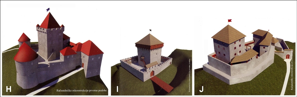
Figure 4: »Three Castles« pre-1511 earthquake computer reconstruction. You can visit all three locations following a marked trail of Three Castles, beginning at Skofja Loka castle. Reference No. 8:
H – Loski grad (Skofja Loka castle), completely rebuilt and in use as a Loka Museum today;
I – Stolp na Kranclju (Krancelj Tower), located at the ridge, very close to Skofja Loka castle; destructed in the earthquake, all remaining structures have been removed and stone used for renovation of the neighboring Skofja Loka castle; Items from Krancelj are displayed as a permanent exhibition in Loka Museum;
J – grad Divja Loka (Wildenlack castle), heavily damaged in the earthquake, left in ruin and deserted.
EARTHCACHE WAYPOINTS HIKE
We recommend you to park your car at waypoint PK, near the bus station. There are only few steps to cross bridge over river Selska Sora and reach the old part of town, which is declared a cultural heritage today. Pass the church and descent to waypoint wp1 at Spodnji trg (Lower square), where an old granary is located. Granary has been heavily damaged in the earthquake, but expressly rebuilt by Bishop Philip. Wishing his contribution to renovation would not be forgotten, he ordered stone-plate with an appropriate text engraved, to be set at the outer wall. Plate is still there to be seen today. There is no grain stored in the granary today, but you can get a delicious meal in the guesthouse there.
Ascend back up to the Mestni trg (Town square), question to answer here. There have been only a few completely built houses in the city, except the castle, church and city walls in 1511 there. Majority have been completely made of wood, or with a built ground floor at best. Read short description of objects at "Cultural property" plates.
Stop in front of former rectory at Mestni trg 38, waypoint wp2. Building has been merged by two older objects. In 1511 house has been owned by influential citizen, imperial advisor Volbenk Schwarz. A stone plate with his family coat of arms is still built in the front wall of the house. In the gratitude, because his house has not been severely damaged in the earthquake, he has built a chapel in the house. Verses written on the wall have been found there, describing important events of early 16th century, including earthquake.
Trail from Mestni trg to the Skofja Loka caslte starts at the waypoint wp3. You come to the large courtyard of Skofja Loka castle at the waypoint wp4. There is a Loka Museum in the castle today, and we are strongly recommend you to visit it! There are many interesting permanent and temporary exhibitons at display there, also one about the Krancelj tower, which has been standing until 1511, with all the artifacts found there.
Take a walk around the castle, across the small garden, pass southeast tower to the side castle entrance. Waypoint wp5 and EarthCache coordinates are set there, in front of the northeast tower. You can see a stone plate above the entrance, which informs you: “The castle of the lord of Freising church, has been ruined at this place on the day of March 26th in the year of our Lord 1511. Our reverend lord and serene duke, Lord’s lord, Philip, the Bishop of Freising, the palatine of Rhine, the duke of Bavaria, has started the repairs from foundations in the year 1513, and in the year 1516 has raised it from the ruin, and taken care that it has been used to his benefit and to the benefit of his successors in the following years.”
Another stone plate, almost the same as the one described above, with the inscription in Latin, has been originally located at the walls of central tower. When central tower has been dismantled, plate has been built in the corridor wall, and is on display inside the Museum today.
You could continue this EarthCache hike with a walk to the ruin of Divja Loka (Wildenlack) castle, which is located at coordinates N 46° 09.783 E 014° 17.242. There is also a traditional cache GC1K19R to be found there.

Figure 5: Skofja Loka Old town map, with marked waypoints and Earthcache coordinates. A special sign (as the one at upper right part of this map) is used to mark buildings designated as cultural property. Taken from web-site www.skofjaloka.info.
References:
1. Matevz Kosic, Ina Cecic, New findings on the 26 March 1511 Earthquake, Idrijski razgledi 1/2011, Mestni muzej, Idrija, 2011.
2. Rafael Bizjak, Idrija on the Turn of 16th Century, Idrijski razgledi 1/2011 (addendum, corrected article), Mestni muzej, Idrija, 2011.
3. R. Camassi, C.H. Caracciolo, V. Castelli, D. Slejko, The 1511 Eastern Alps earthquakes: a critical update and comparison of existing macroseismic datasets. Journal of Seismology, 2011.
4. Marijan Polak, Andrej Gosar, Mladen Zivic, Active tectonics in Slovenia, GeoActa, 9460_Sp3 and ADRIA 2006 – International Geological Congress on the Adriatic area.
5. Janez Kavcic, 500th anniversary of the strongest Earthquake at our territory, Komunikator, Volume 11, st. 58, March 2011, FMR-MEDIA, Idrija.
6. Ina Cecic, Earthquakes in the area of the Idrija fault, Idrijski razgledi 1/2011, Mestni muzej, Idrija, 2011.
7. Snezana Malenovic, Graduation thesis, Riba Faronika (Fish Faronika), Maribor University, Faculty of Education, Fine art Department, Maribor, 2010.
8. Tomaz Kriznar et.al., Pot treh gradov, brochure, Turisticno drustvo Skofja Loka, June 2011.
9. Photos at Figure 1:
A and B – fresco painting at church of St. Kancian, Vrzdenec,
C - www.7dni.com,
D, E, F – reference No. 7,
G – reference No. 5,
Slovensko besedilo
Obiscite naso spletno stran Geološki zakladi / EarthCaches
za seznam vseh nasih Geoloških zakladov in mnogo dodatnih podatkov.
VOJNA, KUGA, LAKOTA POTEM PA SE RIBA FARONIKA!
Nasim prednikom na zahodnem delu slovenskega ozemlja in v sosednji Furlaniji res ni bilo lahko! Zgodovinarji se strinjajo, da je bilo na tem obmocju leta 1511 veliko nesrecnih dogodkov. Habsburzani in Beneska republika so bili v vojni ze od leta 1508.
Poleg vojne in njenih posledic je v letu 1510 izbruhnila epidemija kuge, ki so ji februarja 1511 sledili upori, ropi in pozigi razlicnih oborozenih skupin, predvsem v Furlaniji. Kuga je najhuje prizadela Furlanijo in Benecijo. Tudi lakota je v tem obdobju terjala veliko smrtnih zrtev. V Vidmu so mrtve zakopavali kar na, oziroma ob ulicah, ker na pokopaliscih ni bilo vec prostora.
Kot ponavadi, so najvec hudega morali pretrpeti preprosti ljudje. Potem pa se je zbudila se riba Faronika! Po tedanjem ljudskem verovanju, naj bi namrec v morju kraljevala riba Faronika, pol deklica, pol riba. Ob njenem premikanju pa naj bi se stresala zemlja in nastajale poplave, ce bi se Faronika obrnila na hrbet ali potopila, pa naj bi povzrocila kar »konec sveta«… Tako, se je sredi vsega nastetega gorja, po verovanju, preprostih ljudi, zacela sunkovito premikati se Faronika!
Slika 1: Riba Faronika iz ljudskega verovanja je upodobljena na mnogih cerkvenih freskah (A, B, C, G), ponavadi v blizini sv. Kristofa, ki naj bi varoval pred njeno nevarnostjo. Pojavlja se v ljudskih pesmih, v zapisih (D – srednjeveski rokopis iz Bistre), kot okras izklesan v kamnu (E). Da se ni izginila iz spomina, dokazujejo moderne risbe (F – France Mihelic, 1955); viri st. 9.
POTRES!
26. marca 1511, okrog tretje ure popoldne, je prislo do enega najmocnejsih potresov v tem delu Evrope. Mnogo poznanih posledic potresa so zabelezili ocividci.
V Bavarski drzavni knjiznici v Münchnu je shranjeno na roko napisano pismo, v katerem beremo: »28. dne marca leta gospodovega 1511 je Jurij plemeniti Egkh vicedom na Kranjskem (vladarjev namestnik v dezeli, op. pisca) iz Ljubljane prical in zapisal Pavlu plemenitemu Liechtensteinu: »Bog pa je dezeli poslal se strasen, grozen in nezaslisan potres, ki se je zgodil 26. marca, in stevilni so sledili od tega dneva, dnevno dan in noc, a so postajali sibkejsi. Povzrocil je skodo in porusenje zgradb, mest, gradov, cerkva in drugih nepremicnin...« Nekaj dni kasneje, od 7. do 14. aprila, v uradni korespondenci Kranjskega dezelnega zbora s cesarjem Maximiljanom I. najdemo se nekaj podatkov: »Z zasutjem in podrtjem je bila unicena velika kolicina zit in drugih zivil, posebno na Krasu, v Istri in na Kranjskem, cesar se ne more nadomestiti niti s 100.000 goldinarji.«
Zapis lastnika ali bralca na zadnji strani knjige Sacra Biblia, ki jo hranijo v ljubljanski Narodni in univerzitetni knjiznici, vsebuje notice o velikem potresu, kakor ga je bilo cutiti v Ljubljani: »26. marca, sreda ob 3. uri popoldne je prisel strasno mocan potres v treh sunkih kar je trajalo eno uro (s presledki), potem je prihajal dnevno in v trajanju nekaj ur; v petek popoldne ob 2. uri je bil mocan. Tresenje je bilo tako mocno, da se je cerkev krizevnikov v Ljubljani in mnogo drugih his zrusilo…«
ZARISCE POTRESA IN VZROK
Nekateri seizmologi postavljajo zarisce tega potresa v Furlanijo in ga primerjajo s tistim iz leta 1976, ki se je zgodil pri Huminu in zahteval 1.000 smrtnih zrtev. Drugi ga, predvsem zaradi podatkov iz Idrije, postavljajo na Idrijski prelom.
Idrijski prelom je morfolosko najjasneje izrazena, preko 120 km dolga prelomna cona v zahodnem delu Slovenije. Zelo jasno je vidna ze na satelitskih posnetkih. Zacenja se v Italiji, cez slovensko ozemlje poteka v ravni liniji od Zage na Soci, preko Idrije, Planinskega in Cerkniskega polja, do Babnega polja ter se nadaljuje na Hrvasko. Je se danes aktiven desno-zmicni prelom.
Slika 2a: Seizmicno-tektnoska karta Vzhodnih Alp. Rdece crte predstavljajo prelome, posebej je oznacen Idrijski prelom. Modre oznake so zarisca potresov magnitude vec kot 4,0 pred letom 1900 (sestkotniki) in po 1900 (krogi). Crne zvezde oznacujejo zarisce potresa 1511 kakor so ga dolocili razlicni avtorji: (1) Ambraseys (1976), (2) in (3) Ribaric (1979), (4) Postpischl (1985), (5) Boschi in sod. (2000), (6) CPTI Working Group (2004) ter (7) Fitzko in sod. (2005); Modro beli zogi predstavljata fokalni mehanizem potresov 1976 (Slejko in sod., 1999) in 1998 (Zupancic in sod., 2001); Vir 3.
Slika. 2b – Ucinki potresa 1511 na ozemlju Slovenije in v zamejstvu. Podatki za Italijo in Avstrijo so prirejeni po Camassi in sod., 2010; Podatki za kraje so razvrsceni glede na stopnjo opisanih poskodb in glede na vrsto dostopnih podatkovnih virov; Vir 1.
O mestu zarisca potresa, obstaja vec teorij. Najvec skode je naredil v furlanskih mestih Cedad (Cividale del Friuli), Humin (Gemona del Friuli) in Osovk (Osoppo). Cutili so ga dalec naokrog, vse do severa danasnje Nemcije in Ceske. Pripisovali so mu poskodbe objektov v Benetkah, Zagrebu in na Dunaju. Kaj vse od tega drzi in kaj je posledica napacnega sklepanja ali prepisovanja, seizmologi in zgodovinarji se ugotavljajo. Izdelan je bil pregled doslej predlaganih lokacij za zarisce potresa (slika 2a). Obmocje visoke intenzitete potresa je imelo središče v okolici Cedada, vendar je bilo mocno podaljsano proti zahodu in tudi proti vzhodu in jugovzhodu. Tega pri novejsih mocnih potresih leta 1976 in 1998 ni bilo opaziti! Avtorji so mnenja, da bi pri potresu 1511 lahko slo za premike na sticiscu tektonskih sistemov Juznih Alp in Dinaridov.
ZBIR DOSLEJ ZNANIH PODATKOV O POTRESU
Zarisce: ob Idrijskem prelomu ali v njegovi blizini; moznih je vec lokacij od Idrije do Cedada;
Najvecja intenziteta: X. stopnja EMS-98, v Furlaniji
Ocenjena magnituda: 6,8 - 6,9.
Slika 3: Izoseiste (crte, ki omejujejo obmocja z enakimi ucinki potresa) sedme stopnje po Evropski potresni lestvici (EMS); Primerjava petih najmocnejsih potresov na obmocju Slovenije: 1511 (Idrija), 1895 (Ljubljana), 1926 (Cerknica), 1976 (Furlanija) in 1998 (Zgornje Posocje); kartografija: M. Zivcic, P. Zupancic – Agencija Republike Slovenije za okolje, Urad za seizmologijo in geologijo; Vir 6.
POSLEDICE POTRESA V SLOVENIJI
Porocila o posledicah potresa, obstajajo za naslednja naselja: Tolmin, Bovec, Skofja Loka, Ljubljana, Radovljica, Polhov Gradec, Postojna, Celje, Cerknica in drugi. Se vec je porocil o porusitvah in poskodbah posameznih gradov Divja Loka (Stari grad) pri Skofji Loki, Hosperk (Haasberg) na Planinskem polju, Turjak, Gutenberg in Glanz (Klanc) pri Trzicu, Hudi grad nad Bistrico, Bled, Neuburg (Novi grad) pri Preddvoru, gradova v Kamniku, Prezek v Gorjancih, Stari grad pri Smledniku, Kamen, Duplje, Steberk in drugi. Poskodovane so bile stevilne cerkve in ostale zidane stavbe.
Za Idrijo so zgodovinski viri o posledicah potresa le posredni. V Idriji so komaj tri leta pred potresom odkrili vecje kolicine zivega srebra in priceli z rudniskim izkoriscanjem. Rudniski jaski in zunanji objekti so bili v potresu poskodovani. Kako obsezne so bile poskodbe ni povsem jasno, a obnovo rudnika so zakljucili sele leta 1517! Sicer pa je bila leta 1511 vecina stavb lesenih, verjetno je bilo zidanih le nekaj stavb – cerkev, kapela in hisa, v kateri je stanoval rudniski upravitelj. Kot da sam potres ne bi bil dovolj, je Idrijo doletela se druga velika katastrofa - pri Rupcerju, pod Oblocnikom se je sprozil velik zemeljski plaz, zasul strugo Idrijce, voda pa je poplavila celotno rudarsko naselbino in rudnik! Mesto podora je vidno se danes. Zelo verjetno je plazenje povzrocil prav potres leta 1511, zagotovo pa to ni! Dogodek je zabelezen tudi v rudniskih knjigah, vendar datum podora ni zapisan in je mogoce, da se je plaz sprozil pozneje.
Dobro je dokumentirana skoda v Skofji Loki. Se danes si lahko ogledamo spominske plosce na gradu in na kasci. V kapeli, v Schwarzovi hisi so odkrili napis v heksametrih, ki je med drugim govoril tudi o potresu in njegovih posledicah. Kljub velikim poskodbam v mestu je tedanji skof v kratkem casu obnovil mesto, da je to kmalu spet zacvetelo. Stevilne stavbe iz tistega casa stojijo se danes.
O razmerah v Tolminu in Bovcu je Marino Sanudo v Benetkah v svoje dnevnike skrbno prepisoval podatke iz svoje obsezne mednarodne korespondence. Po porocilu ocividcev je sklepati, da je bil Bovec popolnoma porusen in unicen, pomembna gorska cesta cez Predel zaprta, ker sta se »…dva sosednja hriba zrusila en proti drugemu in zaprla cesto v Nemcijo…«. O Tolminu so porocali, da se je podrl grad in da so ga njegovi cuvaji zapustili.
V Ljubljani so se uradniki Dezelnih stanov za Kranjsko morali preseliti iz svoje hise, ker je bila v potresu tako poskodovana, da ni bila primerna za bivanje. Egkh nasteva poskodbe danasnjih Krizank s cerkvijo, vicedomove palace in drugih dobro grajenih his. Po njegovih besedah so bile »…stevilne druge hise… tako razmajane in razpokane, da ljudje ne zivijo vec v njih, ampak so vsi morali zapustiti mesto in pocakati v predmestjih in drugih pristavah ostati tako dolgo, dokler taksni potresi ali bozja jeza ne ponehajo.« (4; prevedel M. Kosir). Navaja se, da je razpokalo in se podrlo osem stolpov skupaj z delom mestnega obzidja.
POSLEDICE V ITALIJI IN DRUGOD
Potres je najmocneje prizadel furlanske kraje Cedad (Cividale del Friuli), Humin (Gemona del Friuli) in Osovk (Osoppo). Zaradi zidane gradnje, ki se je tam razvila ze v 14. stoletju, so se podirali gradovi in mesta ter zidane hise po vaseh. Ocene o stevilu mrtvih so se vedno zelo ohlapne, ceprav se raziskovalci strinjajo, da je stevilka 12.000 zrtev iz starejse literature precej pretirana. Poleg poskodb v mestih in na vaseh so pokrajino prizadeli tudi stevilni zemeljski plazovi.
Marino Sanudo poroca se o hudih posledicah potresa v Beljaku (Villach), Krminu (Cormons), Gradiscu ob Soci (Gradisca d'Isonzo), Trzicu (Monfalcone) in Gorici (Gorizia).
V Benetkah je reka Livenza med potresom nenadoma zastala in valovi v kanalih so dosegli visino pritlicnih oken, poskodovana pa je bila tudi cerkev svetega Marka. Egkh poroca o poskodbah na cerkvi sv. Stefana na Dunaju. Ucinki v Zagrebu so bili tako mocni, da so bili mescani tri leta po potresu oprosceni placila davkov. Pisni viri pravijo, da so tresenje tal cutili celo na severu Nemcije in na Ceskem.
GEOLOŠKI ZAKLAD
Ceprav je slo za veliko sprostitev energije na prelomu, ob stiku dveh delov zemeljske skorje, neposrednih posledic danes ne vidimo vec. Ce bi kdaj potrdili povezavo potresa iz 1511 in podora pri Idriji, bi bil to eden redkih se vidnih ostankov v naravi. Nekaj drugega pa so objekti, ki so bili v potresu poskodovani. Mnogih med njimi, predvsem gradov in cerkva na stevilnih gricih nikoli niso obnovili, ostanke vecine bi nasli le se z arheoloskimi izkopavanji.
Vendar je med objekti opuscenimi po potresu tudi kaksna izjema. Ena od teh so obodni zidovi gradu Divja Loka ali Starega gradu pod Lubnikom. Tja vas popelje kratek sprehod po oznaceni poti “Treh gradov”, z zacetkom pri Loskem gradu in ciljem na koordinatah N 46° 09.783 E 014° 17.242. Glede na starost, poskodbe v potresu in izpostavljenost vplivom okolja, se je do danes ohranil presenetljivo velik del zidovja!
Tretjo skupino predstavljajo objekti, ki so jih po potresu temeljito obnovili in so v uporabi se danes. Najlepse si lahko ogledate v Skofji Loki, zato smo k Loskemu gradu postavili tudi koordinate Geološkega zaklada.
Slika 4: »Trije gradovi« racunalniska rekonstrukcija stanja pred potresom 1511. Lahko se sprehodite po oznaceni Poti treh gradov z zacetkom pri Loskem gradu. vir 8:
H – Loski grad, popolnoma prenovljen, v njem je danes Loski muzej;
I – Stolp na Kranclju, stal je na bliznjem grebenu, porusen v potresu; Material iz rusevin so porabili za obnovo Loskega gradu; Predmeti iz stolpa so na stalni razstavi v Loskem muzeju;
J – grad Divja Loka, mocno poskodovan v potresu, neobnovljen, ni bil vec v uporabi..
SPREHOD PO TOCKAH ZAKLADA
Priporocamo parkirisce nasproti avtobusne postaje, tocka PK. Žal od lanske jeseni parkitanje tam ni več brezplačno. V nekaj korakih ste po mostu cez Selsko Soro in v starem, spomenisko zascitenem delu mesta. Mimo cerkve se spustite na Spodnji trg do tocke wp1, kjer stoji znamenita stara grascinska kasca. V potresu je bila kasca mocno poskodovana, a je podjetni skof Filip hitro poskrbel za temeljito obnovo. Da njegov prispevek ne bi bil pozabljen, je dal izklesati kamnito plosco z ustreznim napisom in jo vgraditi v obodno steno, kjer je se danes. V kasci danes ne hranijo vec zita, lahko pa ste dobro postrezeni v gostiscu.
Povzpnite se nazaj na zgornji, Mestni trg (tukaj odgovorite na vprasanje). V casu potresa je bilo v mestu poleg gradu, cerkva in mestnega obzidja le nekaj zidanih stavb, v lasti najpremoznejsih mescanov. Vecina ostalih je bila lesenih, nekatere z zidanimi pritlicji. Na Mestnem trgu si oglejte tablice z oznakami spomenisko zascitenih his, pod katerimi je nekaj besed o posameznem objektu.
Ustavite se pred nekdanjim zupniscem na Mestnem trgu 38, tocka wp2, ki je nastalo z zdruzitvijo dveh starejsih objektov. V casu potresa je bil objekt v lasti pomembnega mescana, cesarjevega svetnika, Volbenka Schwarza. Na to kaze kamnita plosca na fasadi, z grbom Schwarzove rodbine. V zahvalo, ker se hisa ni podrla, je dal lastnik v njej leta 1513 postaviti kapelo. Na steni kapele so nasli verze z opisom nekaterih pomembnih dogodkov iz tistega obdobja, med drugim tudi potresa.
Po poti z zacetkom na tocki wp3, se povzpnite k Loskemu gradu. Tocke wp4 vas pripelje na veliko grajsko dvorisce. V gradu danes domuje Loski muzej, katerega ogled toplo priporocamo! Med zbirkami so tudi predmeti iz drugega gradu ali stolpa na Kranclju, ki je do potresa 1511 stal na vzpetini nedalec nad Loskim gradom.
Sprehodite se okoli gradu cez mali vrt in mimo jugovzhodnega stolpa s kapelo, do stranskega vhoda v severovzhodni stolp, kamor so postavljene tudi koordinate tocke wp5 in Geološkega zaklada. Nad vhodnimi vrati je v steno gradu vzidana kamnita plosca z napisom: »Grad gospoda freisinske cerkve, ki je bil na tem mestu dne 26. marca 1511 po Kr. porusen po potresu, je precastiti gospodar in presvetli knez, gospod gospodov Filip, freisinski skof, renski palatin in bavarski vojvoda zacel leta 1513 od temeljev popravljati ter ga leta 1516 po istem stetju dvignil iz rusevin in poskrbel, daje bil v naslednjih letih v njegovo korist in v korist naslednikom iste cerkve popolnoma obnovljen.«
V pritlicju muzeja je shranjena druga plosca, ki je bila vzidana na obodni zid nekdanjega osrednjega grajskega stolpa. Tega pa so kasnejse uporabnice gradu, Ursulinke, dale porusiti, plosco pa vzidati v notranji hodnik. Ta plosca je skoraj povsem enaka prvi, v njej je vklesan zapis v latinscini. Obe plosci je, dal vzidati eden od naslednikov skofa Filipa.
Ce zelite ta Geološki zaklad zdruziti s kratkim izletom, nadaljujte pot do rusevin tretjega gradu imenovanega Divja Loka, na koordinatah N 46° 09.783 E 014° 17.242. Tam lahko poiscete tudi tradicionalni zakladek GC1K19R.
Slika 5: Karta starega dela Skofje Loke z oznacenimi tockami poti in Geološkim zakladom. Za oznacitev spomenisko zascitenih objektov se uporablja oznaka, kakrsna je v desnem zgornjem kotu slike. Vir: www.skofjaloka.info.
Viri:
1. Matevz Kosic, Ina Cecic, Potres 26. marca 1511 v luci novih raziskav, Idrijski razgledi 1/2011, Mestni muzej, Idrija, 2011.
2. Rafael Bizjak, Idrija na prelomu 16. stoletja, Idrijski razgledi 1/2011 (dodatek, popravljen clanek), Mestni muzej, Idrija, 2011.
3. R. Camassi, C.H. Caracciolo, V. Castelli, D. Slejko, The 1511 Eastern Alps earthquakes: a critical update and comparison of existing macroseismic datasets. Journal of Seismology, 2011.
4. Marijan Polak, Andrej Gosar, Mladen Zivic, Active tectonics in Slovenia, GeoActa, 9460_Sp3 and abstracts from ADRIA 2006 – International Geological Congress on the Adriatic area.
5. Janez Kavcic, Ob 500-letnici najhujsega potresa v nasih krajih, Komunikator, letnik 11, st. 58, marec 2011, FMR-MEDIA, Idrija.
6. Ina Cecic, Potresi ob idrijskem prelomu in premiki ob njem, Idrijski razgledi 1/2011, Mestni muzej, Idrija, 2011.
7. Snezana Malenovic, Diplomsko delo, Riba Faronika, Univerza v Mariboru, Pedagoska fakulteta, Oddelek za likovno umetnost, Maribor, 2010.
8. Tomaz Kriznar in sod., Pot treh gradov, brosura, Turisticno drustvo Skofja Loka, junij 2011.
9. Fotografije na sliki 1:
A in B – freska na cerkvi sv. Kancijana, Vrzdenec,
C - www.7dni.com,
D, E, F – vir st. 7,
G –vir st. 5,
tocke poti in dnevniki / waypoints and logs