This is 1 of 12 EarthCache sights in the SRWT. The first 100 to complete the trail will receive a geocoin commerating the SRWT, 60 of which are trackable. These will be available at the Mercer County Conservation District office Mon.- Fri. from 8 am to 4 pm after April 21st. We are located at 753 Greenville Road, Mercer, PA 16137. To learn more about this geoWatershed Trail, visit us by clicking here.
SHENANGO RIVER HISTORY (Mondok, 1990)
The Shenango River Basin is shared by the state of Ohio and the Commonwealth of Pennsylvania. The river and its tributaries drain 744 square miles of the Pennsylvania counties of Crawford, Lawrence, and Mercer and 285 square miles of the Ohio counties of Ashtabula, Mahoning, and Trumbull. The waters and its tributaries have been used for transportation such as the Erie Extension Canal, watering livestock, and other household uses.
Prior to European settlement, the land area of the Shenango was inhabited by many indian tribes including the Seneca and the Delaware. The word Shenango itself comes from the Iroquoian word Shaningo meaning “beautiful one”.
The 75 mile long river begins in the marshes that are now part of Pymatuning Reservoir near Hartstown in Crawford County and eventually meets the Mahoning River near New Castle in Lawrence County.
ICE AGE INFLUENCES (Mondok, 1990)
The topography and soils in Pennsylvania and Ohio were shaped during the Ice Age that ended about 10, 000 years ago. Prior to this glacial epoch, the Shenango River flowed in a northerly direction to the Atlantic Ocean via the Great Lakes and St. Lawrence River. This dissected plateau was covered by glaciers; some were a mile thick in some places. Boulders, rocks, soil, sand, silt, and clay were carried with the glacial ice and deposited on glacial till, kame terraces, moraines, and eskers when the ice melts as the climate warmed. These deposits were so vast, that their ancient river valleys were filled, causing the flow from the Atlantic Ocean to the Gulf of Mexico.
FORMATION OF WATERFALLS
Waterfall formation occurs due to the basic principle of erosion. To put it simply, there is a water source that travels over different types of rocks that have various rates of erosion. Rocks with slow rates of erosion will take time before they begin to erode; these are referred to as hard rock. On the other hand, rocks with high rates of erosion quickly erode (J. Cheng, 2012).
As time progresses, the soft rock is further eroded by the water; this ultimately makes the watercourse steeper beyond the hard rock layer. As the watercourse continues to steepen, it accelerates erosion of the soft rock due to the influence of gravity on the water’s speed. Cascades and rapids are examples of this stage. Eventually, the watercourse steepens until it is vertical. It can now be referred to as a waterfall (J. Cheng, 2012).
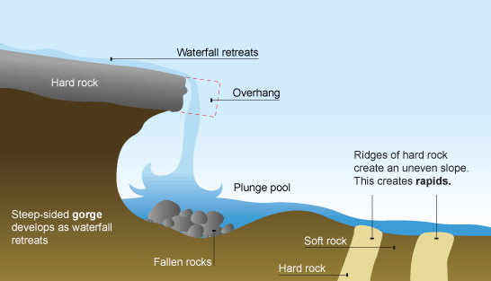
As the watercourse continues to cut the softer rock, the waterfall gets taller, and the plunge pool gets deeper. Sometimes this soft rock is undercut so much, that the hard rock becomes an overhang. If this undercutting continues on, the hard rock overhang can get unstable and collapse. This causes the waterfall to retreat upstream to the remaining lip of the rock layer (J. Cheng, 2012).

TYPES OF WATERFALLS
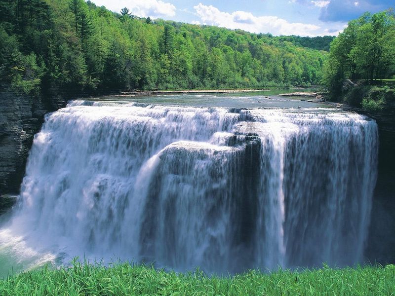
There are seven basic types of waterfalls: plunge, horsetail, cascades, block, curtain, tiered, and punchbowl. Plunge waterfalls have water that plunges for all or most of its height without coming into contact with the underlying rocks (Rubinstein, P., L.H. Whittlesey, and M. Stevens, 2000). (Note: The description for each waterfall type is located above the picture, not below.
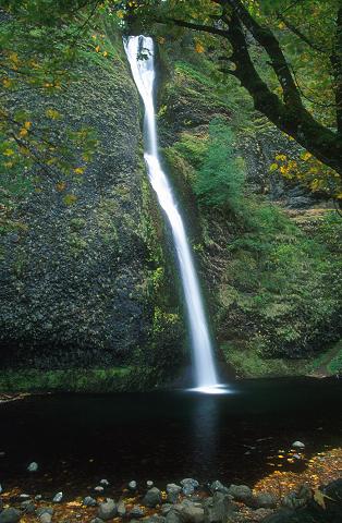
Horsetail waterfalls have water that descends down a near-vertical wall, all the while maintaining contact with the underlying rock (Rubinstein, P., L.H. Whittlesey, and M. Stevens, 2000).
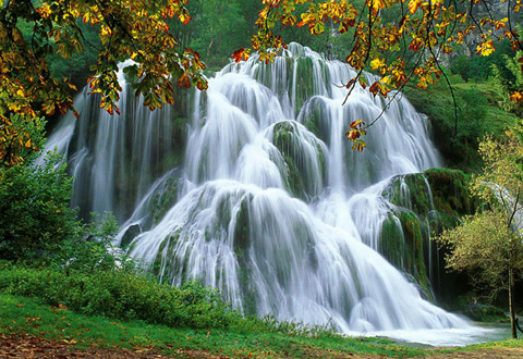
Cascades have water that flows at an angle over a series rocks or down a broad rock face with too many leaps to count. They are often the results of waterfalls eroding upstream (Rubinstein, P., L.H. Whittlesey, and M. Stevens, 2000).
Block waterfalls are formed from a wide river that spills over the edge, thus causing the water to look like a big sheet. It is usually wider than it is high (HowStuffWorks, 2012).
Curtain waterfalls are formed in the similar fashion as block waterfalls. They look like a giant curtain and are characterized by being taller than they are wide (HowStuffWorks, 2012).

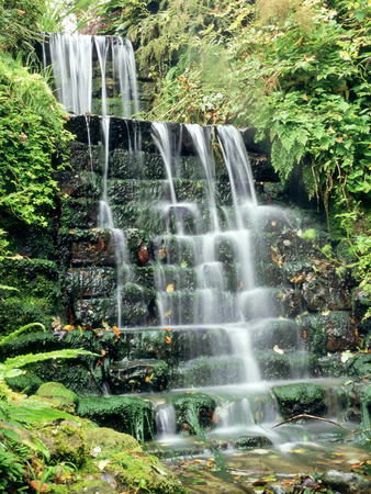
Tiered waterfalls are formed from various ledges. They seem to plunge and fall into a plunge pool that leads the water over another ledge to another plunge pull, etc (HowStuffWorks, 2012).
Punchbowl waterfalls seem to punch the water from a wider river through a narrow area into a plunge pool (HowStuffWorks, 2012).

Note: Do not be surprised when you see waterfalls that have characteristics of more than one of the types listed above. Many waterfalls have features that cause them to fall under a few different type categories. Waterfalls are usually given one main type classification with fall modifiers that better specify it.
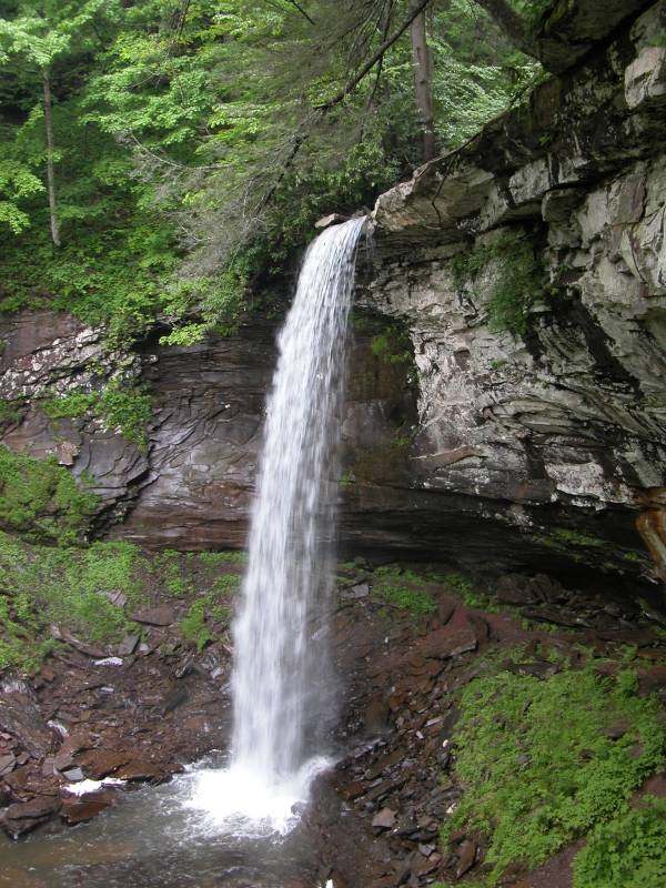
SPRINGFIELD FALLS
Springfield Falls are located on Schollard’s Run. It is one of only a handful of waterfalls located in the Shenango River Watershed. It is roughly 13 feet high and over 60 feet wide with a constant flow of water throughout the year. It’s crazy that such a small stream can fan out and flow over 60 feet wide.
The rocks that are behind the Springfield Falls are known as sedimentary rocks. Sedimentary rocks are formed due to the forces of erosion by wind, water, and weathering. Over time, rocks erode and break down into pieces. These pieces travel down rivers and streams until they eventually settle on the bottom as sediment. Eventually, they are pressed together and form sedimentary rocks (ThinkQuest, 2000). The sedimentary rocks that are located in Springfield Falls originate from the Inland Sea that once occupied much of the area over 400 million years ago.
There are several types of rocks that are classified as sedimentary. Shale, conglomerous, sandstone, and limestone are some of the common sedimentary rocks. The rocks behind Springfield Falls are mainly sandstone and shale. These were formed during the Pennsyvlania Era. This period is characterized by cyclic sequences of sandstone, shale, conglomerate, clay, coal, and limestone.
The area surrounding these falls was heavily mined for coal throughout the 20th century. In the 1900s, various deep and surface mines were located throughout the area that focused on this coal (Barnes, 2004).
Coal surrounding the Springfield Falls comes from the Carboniferous Pennsylvanian period. Coal is also a sedimentary rock, but it is different than others because it is mostly made of materials other than minerals. It forms from plant remains such as wood, bark, and leaves. These plants that formed the PA coal lived in warm, swampy environments. When the plants died, they fell into the stagnant water of the swamps, eventually forming peat. The peat became buried deeply enough that the pressure and heat contributed to the lithification (Barnes, 2004).

COORDINATES TO PARKING AREA
The parking area and location of the swamp are the same coordinates:
N 41 08.628' W 080 13.044'
TO GET CREDIT FOR THIS CACHE:
Please be sure to send your answers to the following questions to jmccullough@mcc.co.mercer.pa.us in order to receive credit for this cache.
1. Describe the streambed above the falls.
2. Describe the falls themselves. What type of waterfall does it appear to be based off of the classification of waterfalls
A special thank you to the Pennsylvania Game Commission for permission to place this EarthCache.
References:
Barnes, J. 2004. Rocks and Minerals of Pennsylvania. Educational Series 1, 21.
Cheng, J. 2012. Waterfalls 101. World of Waterfalls. Retrieved from: http://www.world-of-waterfalls.com/featured-articles-waterfalls-101.html
HowStuffWorks. 2012. How Waterfalls Work. Retrieved from: http://geography.howstuffworks.com/terms-and-associations/waterfall2.htm
Mondok, J. 1990. The Shenango River. Shenango Riverscapes, 1-2.
ThinkQuest. 2000. Sedimentary Rocks. Retrieved from: http://library.thinkquest.org/J002289/sed.html
Pictures retrieved from:
http://geography.howstuffworks.com/terms-and-associations/waterfall2.htm
http://www.google.com/imgres?q=plunge+waterfall&um=1&hl=en&sa=N&biw=1366&bih=673&tbm=isch&tbnid=h-D07mHIiIWbQM:&imgrefurl=http://gowaterfalling.com/waterfalls/hillcreeklower.shtml&docid=dwvbKtV5KstSkM&imgurl=http://gowaterfalling.com/waterfalls/images/full/wv/vhillcreekfallslower1.jpg&w=600&h=800&ei=m3M1T-_eMqXY0QGjr8jNAQ&zoom=1&iact=hc&vpx=395&vpy=127&dur=10112&hovh=259&hovw=194&tx=145&ty=150&sig=104497807145258919721&page=1&tbnh=158&tbnw=118&start=0&ndsp=20&ved=1t:429,r:1,s:0
http://www.google.com/imgres?q=Horsetail+waterfall&um=1&hl=en&sa=N&biw=1366&bih=673&tbm=isch&tbnid=w_gwsP0ve6Z0wM:&imgrefurl=http://kevingong.com/Hiking/TripleFalls.html&docid=yM0XrP1luh-ZGM&imgurl=http://kevingong.com/Hiking/Images/200110TripleFalls/B15HorsetailFalls001.jpg&w=314&h=480&ei=GXQ1T-PqCMfw0gH0t73TAg&zoom=1&iact=hc&vpx=285&vpy=280&dur=2171&hovh=278&hovw=181&tx=108&ty=158&sig=104497807145258919721&page=1&tbnh=140&tbnw=94&start=0&ndsp=27&ved=1t:429,r:10,s:0
http://www.google.com/imgres?q=Cascade&um=1&hl=en&sa=N&biw=1366&bih=673&tbm=isch&tbnid=dReATXGUrQ8owM:&imgrefurl=http://blogs.jwatch.org/hiv-id-observations/index.php/cascade-when-to-start-yet-another-take/2011/10/03/&docid=z9znWumbJf3l4M&imgurl=http://blogs.jwatch.org/hiv-id-observations/wp-content/uploads/2011/10/cascade.jpg&w=480&h=330&ei=X3Q1T8SzJeb50gHRuMHKAg&zoom=1&iact=hc&vpx=861&vpy=305&dur=2542&hovh=186&hovw=271&tx=92&ty=94&sig=104497807145258919721&page=1&tbnh=162&tbnw=191&start=0&ndsp=12&ved=1t:429,r:4,s:0
http://www.google.com/imgres?q=block+waterfalls&um=1&hl=en&sa=N&biw=1366&bih=673&tbm=isch&tbnid=XKFTGFyjTLcerM:&imgrefurl=http://www.vtfalls.com/bristolbartlettfalls.htm&docid=lDNN0Unao5MyqM&imgurl=http://www.vtfalls.com/images/Bartlett_Falls-Bristol_VT.jpg&w=800&h=533&ei=yXQ1T-q5JqXq0gHlzeGlAg&zoom=1&iact=hc&vpx=793&vpy=376&dur=1058&hovh=183&hovw=275&tx=123&ty=120&sig=104497807145258919721&page=1&tbnh=150&tbnw=185&start=0&ndsp=17&ved=1t:429,r:14,s:0
http://www.google.com/imgres?q=block+waterfalls&hl=en&biw=1366&bih=673&tbm=isch&tbnid=P9udOTWnmcgPjM:&imgrefurl=http://ghostnation.blogspot.com/2011/05/free-ed.html&docid=TZwBqtDM3GxBlM&imgurl=http://1.bp.blogspot.com/-Ev5A-ixXhDo/Tcf-kww0jqI/AAAAAAAADSQ/DRm74c5QHNQ/s1600/waterfalls_free_screensaver_desktop_screen_savers-9643-screenshot.jpg&w=800&h=600&ei=-Hc1T9W4LcrX0QG8nbzeAg&zoom=1&iact=hc&vpx=390&vpy=318&dur=1872&hovh=194&hovw=259&tx=87&ty=114&sig=104497807145258919721&page=1&tbnh=142&tbnw=193&start=0&ndsp=17&ved=1t:429,r:7,s:0
http://www.google.com/imgres?q=tiered+waterfalls&hl=en&sa=X&biw=1366&bih=673&tbm=isch&prmd=imvns&tbnid=Gt4DEtTdufB14M:&imgrefurl=http://www.art.com/products/p14292446-sa-i2920787/ron-evans-tiered-waterfall-moss-lichen-ferns.htm&docid=sPHscUfA7WH3IM&imgurl=http://cache2.artprintimages.com/lrg/29/2904/8QVPD00Z.jpg&w=338&h=450&ei=l3U1T7KyLITM0AHf84W0Ag&zoom=1&iact=hc&vpx=849&vpy=123&dur=1845&hovh=259&hovw=194&tx=83&ty=158&sig=104497807145258919721&page=1&tbnh=150&tbnw=113&start=0&ndsp=20&ved=1t:429,r:4,s:0
Rubinstein, P., L.H. Whittlesey, and M. Stevens. 2000. The Guide to Yellowstone Waterfalls and their Discovery. Westcliffe Publishers, Inc., 27-8.
http://faculty.virginia.edu/metals/cases/ramdeen1.html