This is 1 of 12 EarthCache sights in the SRWT. The first 100 to complete the trail will receive a geocoin commerating the SRWT, 60 of which are trackable. These will be available at the Mercer County Conservation District office Mon.- Fri. from 8 am to 4 pm after April 21st. We are located at 753 Greenville Road, Mercer, PA 16137. To learn more about this geoWatershed Trail, visit us by clicking here.
SHENANGO RIVER HISTORY (Mondok, 1990)
The Shenango River Basin is shared by the state of Ohio and the Commonwealth of Pennsylvania. The river and its tributaries drain 744 square miles of the Pennsylvania counties of Crawford, Lawrence, and Mercer and 285 square miles of the Ohio counties of Ashtabula, Mahoning, and Trumbull. The waters and its tributaries have been used for transportation such as the Erie Extension Canal, watering livestock, and other household uses.
Prior to European settlement, the land area of the Shenango was inhabited by many indian tribes including the Seneca and the Delaware. The word Shenango itself comes from the Iroquoian word Shaningo meaning “beautiful one”.
The 75 mile long river begins in the marshes that are now part of Pymatuning Reservoir near Hartstown in Crawford County and eventually meets the Mahoning River near New Castle in Lawrence County.
ICE AGE INFLUENCES (Mondok, 1990)
The topography and soils in Pennsylvania and Ohio were shaped during the Ice Age that ended about 10, 000 years ago. Prior to this glacial epoch, the Shenango River flowed in a northerly direction to the Atlantic Ocean via the Great Lakes and St. Lawrence River. This dissected plateau was covered by glaciers; some were a mile thick in some places. Boulders, rocks, soil, sand, silt, and clay were carried with the glacial ice and deposited on glacial till, kame terraces, moraines, and eskers when the ice melts as the climate warmed. These deposits were so vast, that their ancient river valleys were filled, causing the flow from the Atlantic Ocean to the Gulf of Mexico.
FORMATION OF HARTSTOWN SWAMP
Glaciers not only transport material as they move, they also sculpt and carve away the land beneath them. The combination of the glacier’s weight and its movement greatly impacts the landscape (Ntl Snow and Ice Data Center, 2012). Hartstown Swamp, the headwaters to both Crooked Creek and the Shenango River, was formed back during the glacial epoch. As the glacier moved throughout Northwestern PA, it reshaped the surrounding landscape; in this instance, it created what is now known as Hartstown Swamp.
HARTSTOWN SWAMP
Hartstown Swamp is located at the headwaters of both the Crooked Creek and Shenango River Watersheds. A watershed is a region that is drained by, or one that contributes water to, a stream, lake, or other body of water. Watersheds are surrounded by topographic highs called divides. These divides are any ridges between two streams along which precipitation runs off. They also determine how big the watershed is. Watersheds vary in size due to shape of these divides (Globe Fearon, 2003).
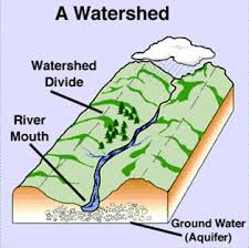
Hartstown Swamp is a unique geo-hydrological feature in that it contains the divide where Crooked Creek and the Shenango River begin. Somewhere beneath the grassy overlay and water of this swamp lies the divide that determines which way the water will flow. Ultimately all water within Hartstown Swamp is part of the Shenango River Watershed because Crooked Creek is a tributary to the Shenango. Water from the Shenango River Watershed eventually becomes part of the Ohio River Basin which ultimately drains into the Mississippi River to the Gulf of Mexico.
COORDINATES TO PARKING AREA
The parking area and location of the swamp are the same coordinates: N 41 33.834' W 080 22.725'
TO GET CREDIT FOR THIS CACHE:
Please be sure to send your answers to the following questions to jmccullough@mcc.co.mercer.pa.us in order to receive credit for this cache.
1. Which direction does the water seem to be flowing?
2. What is the elevation?
References:
Curry's Fork Watershed. (2012). Watershed Education. Picture Retrieved From: http://www.oldhamcounty.net/curry_fork/watershed_Glossary.htm
Globe Fearon. (2003). Chapter 1: Watersheds and Wetlands. Environment and Ecology for Pennsylvania: Meeting the Standards, 10.
Mondok, J. (1990). The Shenango River. Shenango Riverscapes, 1-2.
National Snow and Ice Data Center. (2012). How do Glaciers affect Land? Retrieved from: http://nsidc.org/cryosphere/glaciers/questions/land.html.
A special thank you to the Pennsylvania Game Commission for granting us permission to place this sight.