This is 1 of 12 EarthCache sights in the SRWT. The first 100 to complete the trail will receive a geocoin commerating the SRWT, 60 of which are trackable. These will be available at the Mercer County Conservation District office Mon.- Fri. from 8 am to 4 pm after April 21st. We are located at 753 Greenville Road, Mercer, PA 16137. To learn more about this geoWatershed Trail, visit us by clicking here.
SHENANGO RIVER HISTORY
The Shenango River Basin is shared by the state of Ohio and the Commonwealth of Pennsylvania. The river and its tributaries drain 744 square miles of the Pennsylvania counties of Crawford, Lawrence, and Mercer and 285 square miles of the Ohio counties of Ashtabula, Mahoning, and Trumbull. The waters and its tributaries have been used for transportation such as the Erie Extension Canal, watering livestock, and other household uses.
Prior to European settlement, the land area of the Shenango was inhabited by many indian tribes including the Seneca and the Delaware. The word Shenango itself comes from the Iroquoian word Shaningo meaning “beautiful one”.
The 75 mile long river begins in the marshes that are now part of Pymatuning Reservoir near Hartstown in Crawford County and eventually meets the Mahoning River near New Castle in Lawrence County.
ICE AGE INFLUENCES (Mondok, 1990)
The topography and soils in Pennsylvania and Ohio were shaped during the Ice Age that ended about 10, 000 years ago. Prior to this glacial epoch, the Shenango River flowed in a northerly direction to the Atlantic Ocean via the Great Lakes and St. Lawrence River. This dissected plateau was covered by glaciers; some were a mile thick in some places. Boulders, rocks, soil, sand, silt, and clay were carried with the glacial ice and deposited on glacial till, kame terraces, moraines, and eskers when the ice melts as the climate warmed. These deposits were so vast, that their ancient river valleys were filled, causing the flow from the Atlantic Ocean to the Gulf of Mexico.
OXBOW LAKE HISTORY
Oxbow lakes are common floodplain features around the world; they are remnants of meandering floodplain rivers that have been physically isolated from their respective main river channels and generally catch small relic drainage areas (Cooper, Smith, and Moore, 2003). According to a paper written by Department of Geology John Weihaupt in 1977, “one of the earliest references to oxbow lakes in is in Brigham’s discussion of the constructive and destructive work of rivers in the creation of landforms (Brigham, 1892). He seems to have been the first to use the term “oxbow lake” to refer to crescent-shaped lakes. He was also known for calling them “cut-off” lakes (Weihaupt, 1977).
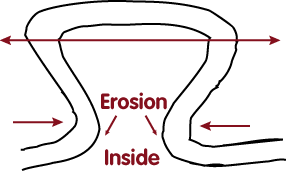
An oxbow lake is formed when a bend in a river is cut-off from the main channel by the forces of erosion and deposition. This type of lake is slowly created as soil erodes and is eventually re-deposited, thus changing the river’s course ( Enchanted Gardens, 2011).
1st Stage: Soil is eroded from areas of the bank where fast-moving water hits it; this soil is re-deposited along the areas of the stream that are slow-moving (Enchanted Gardens, 2011).
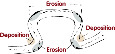
2nd Stage: Eventually, the bend becomes cut-off from the river’s path (Enchanted Gardens, 2011).
Final Stage: Once the river stops flowing from the original path it took, the lake begins to fill up with sediments. It will eventually become a wetlands area (Enchanted Gardens, 2011).
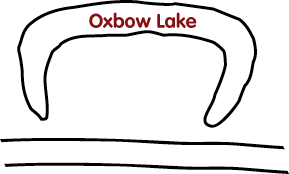
SHENANGO OXBOW LAKE HISTORY
As stated previously, at one time, the Shenango River used to flow north and eventually emptied into the Atlantic Ocean. Due to glaciation, the flow of the Shenango River changed. This oxbow lake is of significance because it is one of the many areas that displays the original flow pattern of the Shenango River.
COORDINATES TO PARKING AREA
For a short hike (roughly .16 miles one way) to the oxbow, park at the coordinates:
N 41 19.954' W 080 20.968'
For a longer hike (roughly 0.75 miles one way) that highlights the Shenango River Trail, park at the coordinates:
N 41 19.451' W080 20.518'
TO GET CREDIT FOR THIS CACHE:
Please be sure to send your answers to the following questions to jmccullough@mcc.co.mercer.pa.us in order to receive credit for this cache.
1. Which way is the water flowing?
2. What kind of animal signs are present in the area?
3. What are the indicators that the floodplain is saturated a good part of the time?
a. Raised area around the oxbow
b. Butressed roots on trees
c. Wetland plant species are present
d.None of the above
e. A & C
f. A, B, & C
References:
Brigham, A.P. (1892). Rivers and the Evolution of Geographic Forms. Journal of the American Geographical Society, 24, 23-43.
Cooper, C., S. Smith, and M. Moore. (2003). Surface Water, Ground Water, and Sediment Quality in Three Oxbow Lake Watersheds in the Mississippi Delta Agricultural Region: Pesticides. International Journal of Ecology and Environmental Sciences, 29, 171-84.
Gardens,E (2011) What is an Oxbow Lake? Retrieved from: http://www.nywetlands.com/oxbowlake.html.
Mondok, J. (1990). The Shenango River. Shenango Riverscapes, 1-2.
Weihaupt, J.G. (1977). Morphometric Definitions and Classifications of Oxbow Lakes, Yukon River Basin, Alaska. Water Resources Research, 1-43.
A special thank you to the U.S. Army Corps of Engineers for granting permission to place this EarthCache.