(SI) Majhno, a globoko kraško jezero, ki se nadaljuje v podvodno jamo.
PRED ZACETKOM:
Opis tega Geološkega zaklada je dolg. Prosimo, preberite ga in si zapisite naloge za vpis se pred obiskom zaklada!
NALOGE ZA VPIS OBISKA
1. Razmislite o naslednjih podatkih:
a) Jezerska voda ima odtok 51 metrov pod gladino jezera;
b) Voda, ki odtece iz Jezera, izvira na drugi strani kamnitega praga, na robu barja;
c) Izviri na barjanski strani so le kak meter pod nivojem gladine Jezera, torej kakih 50 metrov višje od odtoka na jezerskem dnu!
Kako lahko razlozite neoviran iztok vode iz Jezera?
2. Pojdite na konec pomola (točka 01) in sporočite vodostaj glede na zgornji rob pomola v času vašega obiska. Včasih je voda previsoka za dostop na pomol - v tem primeru napišite kako daleč od pomola na obrežje sega voda.
3. S table, ki Jezero oznacuje kot naravni spomenik, prepisite prvo vrstico besedila.
4. Zelo bomo veseli, ce kaksno zanimivo fotografijo z mesta zaklada prilozite svojemu vpisu (logu) obiska.
POMEMBNO!
- Preden vpisete obisk zaklada, posljite odgovor preko GC profila ali neposredno na e-naslov vane.si.geo@gmail.com. Takoj potem lahko vpisete obisk zaklada na spletu – ne potrebujete dodatnega dovoljenja. Ce ste fotografirali, prosimo, prilozite kaksno fotografijo.
- Vpisi brez ustrezne spremljajoce e-poste, ki vsebuje pravilne odgovore, bodo najprej trajno kodirani, kasneje izbrisani!
- Vpisi, ki vsebujejo odgovor bodo izbrisani!
Ob obisku tega zaklada lahko obiscete se nekatere druge v okolici:
- lep tradicionalni Nocni zaklad, GC20BHA,
- Geološki zaklad Ljubljansko Barje, GC3AQZ3 na vrhu Sv. Ane in
- tradicionalni zaklad Svetla Ana, GC13KHV.
(ENG) Small, but deep karstic lake with a sink continuing into the water cave.
BEFORE THE BEGINNING:
This EarthCache has a long description! Please, read it and write down logging tasks before visiting the EarthCache site!
LOGGING TASKS
1. Think about three facts:
a) Lake water has an outflow 51 m below the lake surface;
b) This water springs on the other side of the rocky threshold, at the edge of Ljubljana Marsh;
c) Springs at the Marsh edge are just about a meter under the lake surface level, and therefore about 50 meters above the Lake outflow!
How can you explain the undisturbed outflow of the water from the lake?
2. Go to the end of the pier (virtual stage 01) and let us know the water level at the time of your visit - measure it from the deck of the pier. Sometimes the water is too high to use the pier - in this case, tell us how far upland from the pier the water reach.
3. Write down the first line of the text from the info board.
4. We would be glad if you added interesting photos from the EarthCache location to your log.
IMPORTANT!
- Send answer through GC profile or directly to e-mail vane.si.geo@gmail.com
before logging. After that you can log - you don't need additional permission to log. Please, upload photos if you have taken them.
- Logs without an accompanying e-mail containing correct answers will be encrypted and later deleted!
- Logs containing the answer will be deleted!
While visiting this EarthCache, you can also visit some other caches in the neighbourhood:
- traditional Night cache, GC20BHA in the Jezero surroundings,
- EarthCache Ljubljansko barje: BARJE / THE MARSH, GC3AQZ3 at the top of St. Anna, and
- traditional cache Svetla Ana, GC13KHV.
slovensko besedilo / Slovenian text
tocke poti in dnevniki / waypoints and logs
Visit our website Geološki zakladi / EarthCaches
for a complete list of our EarthCaches and a lot of additional information.
(ENG) JEZERO JEZERO V JEZERU - A TRIPLE LAKE?
This is a triple lake! Well, it is actually just one water body, but the word Jezero in Slovenian literally means Lake. Since the village, where Jezero lies, is named Jezero too, translation into English could be: Lake Lake in the Lake(village).
Jezero, also called Podpeško jezero, is positioned at the Southern edge of Ljubljana marsh, under the Northern slopes of Krim hills. This karstic lake has a circular shape, with a longer diameter of 135 m and a shorter 120 m.
Lake waters fill the Northwestern part of an 800 m long and 400 m wide depression, which is stretched in the Dinaric direction (NW-SE) and is named Zajezero. Depression is filled with thick layers of alluvium and separated from the Ljubljana Marsh basin with a low rock threshold.
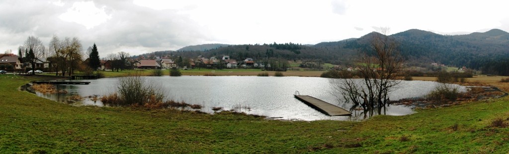
Figure 1: Lake with high water; photo: vane_si
Plain is a proper karst polje with karst springs and underground outflow. The plain is mainly marshland. Lake water edges, all the way to the depth of about 3 m, present habitat of Yellow Water-lily (Nuphar luteum), water perennial from the Nymphaeaceae family. Water-lily leaves are clearly visible from aerial photos.
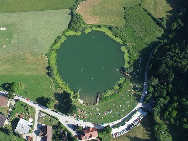
Figure 2: Circular shape of Jezero, and water-lily leaves are clearly visible in this image; photo: Matjaž Vidmar, reference 4
Jezero is a popular destination, especially for fishermen. You can almost always meet some fishermen there. They are attracted by trout, carp and pike. There are lots of sun-bathers and swimmers there in the summer. Other visitors like to seat on the sunny terrace in front of an inn and enjoy a drink with a view across the lake, surrounding plain and hills.
Geocachers usually park their car near the lake and make a short hike to a local hill of St. Ana, which offers a marvellous view across Ljubljana Marsh and a traditional cache GC13KHV. Or, in the evening, try to find a superbly prepared Night cache GC20BHA near the lake.
The majority of all those visitors never realize what is hidden under the waters of Jezero. They might even know the lake is deep but that is all. Local people used to spread rumours about the enormous depth of the lake, which was supposed to be even 80 m under the lake's surface… The truth, for sure, is no less interesting! Therefore even those more informed are not deprived of the imaginary travel while reading or listening about divers and other researchers' discoveries.
Jezero has been declared A Natural monument in 1988. Jezero and the surrounding plain are a part of Ljubljansko barje Nature Park today.
HIDROLOGY
Water drains to the marshy plain from several karst springs in the white limestone and dolomite hillsides at the South-Eastern side of the plain. Sources flow into Mlinski potok (Mill-brook) which fills the lake.
Jezero has no surface outflow. All the water sinks through ponor (sink) at the bottom of the lake, and springs at the edge of Ljubljana Marsh, at the other side of the rocky threshold, near the primary school in the village. Sources are just about 300 m distant from the lake and just a little under the level of the lake's surface. Some water springs from the edge of the alluvium, and the remaining water from the impassable water cave near the road in the village.
Lake water-level doesn’t oscillate very much, only at the time of very high water part of the plain is flooded, and just in extreme situations all of the plain. Underground outflow is obviously very efficient!
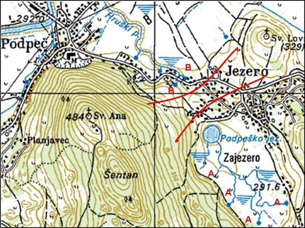
Figure 3: clipping of the topographic map; A – karst sources which drain to the plain and fill Jezero, B – sources filled by water flowing out of Jezero; Red lines show the position of the rocky barrier between Jezero and Ljubljana Marsh;
Peat and alluvium surrounding the lake are very thick, they probably reach the rock base more than ten meters deep. Since there is a rocky threshold separating lake plain from the rest of Ljubljana Marsh, it is almost certain, this is a tectonic depression.

Figure 4: Aerial-photo of Jezero and marshy plain; reference: www.geopedia.si;
STILL WATERS RUN DEEP!
This proverb, usually referred to quiet people with deep character, can be used quite literally in the case of Jezero! The depth of 51 m is deeper than Lake Bohinj even!
The bottom, covered with silt, is slowly descending towards the middle of the lake. At a depth of 8 to 15 m, it declines steeply into a funnel, or sink. Cliffs of this funnel are vertical, in some places even overhanging. At the depth of 17 m, the funnel divides into the Southern and Northern parts. The southern part reaches 29 m and the Northern 22 m. Both parts are connected with a narrow passage through the ridge in a depth of 22 m.
The shallower part of the funnel continues downwards through two narrow fissures. After about 10 m they widen into the lower water cave. There is a lot of silt in the lower cave, except at the site of the outflow. The lower cave itself is about 20 m long, 8 m wide and, under the entrance, 10 m high. The cave is getting lower towards the outflow and has a kind of duck-beak shape. The fissure of the outflow lies 51 m under the lake's surface! It is rather wide, but very shallow, and therefore impassable for divers.
Diving into the lower cave is very demanding and recommended to good cave divers with all appropriate equipment only!
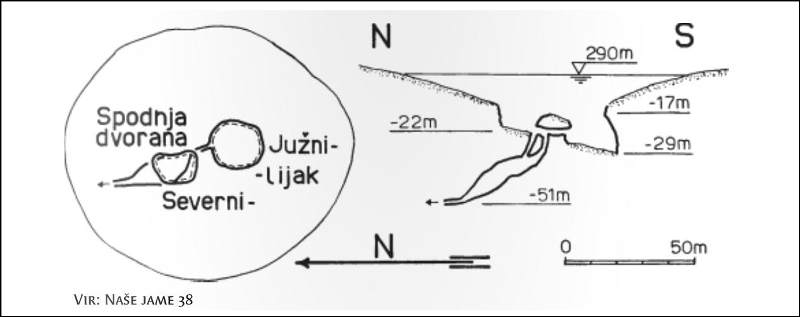
Figure 5: Sketch - lake bottom ground plan and vertical section of the lake; reference 3;
Take a walk to the lake shore and along the edges of the marshy plain. Or just seat on the wooden pier and think about the wonders lying in front of you and beneath.
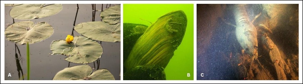
Figure 6: A – yellow water-lily, reference 5; B and C – clamp and crayfish in Jezero, photo Matjaž Vidmar, reference 4;
EARTHCACHE
EarthCache coordinates lead you to the info board near the lake.
References:
1. Ivan Gams, Kras v Sloveniji (Karst in Slovenia), ZRC Publishing, The Scientific research centre of the Slovenian Academy of Sciences and Arts, Ljubljana, 2004;
2. DEDI, Enciklopedy of Slovenian natural and cultural heritage website, Jezero pri Podpeci, author of the text: Mauro Hravtin, The Scientific research centre of the Slovenian Academy of Sciences and Arts);
3. Underwater atlas of Slovenia. Form No. 33, form filled by Matjaz Vidmar;
4. Photos: Matjaz Vidmar, from web site “picasaweb.google.com“;
5. Photo A: manica, from web site “panoramio.com“;
Slovensko besedilo
Obiscite naso spletno stran Geološki zakladi / EarthCaches
za seznam vseh nasih Geoloških zakladov in mnogo dodatnih podatkov.
(SI) TROJNO JEZERO?
Predstavljamo vam trojno Jezero! Jezero v vasi Jezero se namrec imenuje Jezero. Seveda gre le za eno vodno telo! Bolj poznano je drugo ime - Podpesko jezero. Lezi ob juznem robu Ljubljanskega barja, pod severnimi obronki Krimskega hribovja. To krasko jezero je skoraj pravilne okrogle oblike, z daljsim premerom 135 m in krajsim 120 m.
Jezero zapolnjuje severozahodni del 800 m dolge in 400 m siroke kotanje, ki je razpotegnjena v dinarski smeri in ji domacini pravijo Zajezero. Kotanja je na debelo zapolnjena z naplavinami, od ravnice Ljubljanskega barja pa jo loci nizek skalni prag.
Slika 1: jezero z visokim vodostajem; foto: vane_si
Na ravnici okrog jezera prevladuje zamocvirjen svet. Robni deli jezera, do globine priblizno 3 m, so rastisce rumenega blatnika (Nuphar luteum), vodne trajnice iz druzine lokvanjevk. Ta je lepo vidna tudi na posnetkih z zraka.
Slika 2: z zraka je lepo vidna okrogla oblika jezera in obroc listov rumenega blatnika; foto: Matjaz Vidmar, vir 4
Jezero je priljubljena izletniska tocka. Najraje ga imajo ribici, ki jih ob njem najdemo skoraj vedno. Privabljajo jih stevilne ribe, med njimi postrvi, krapi in scuke. Poleti se v vodi namakajo kopalci, ostali izletniki pa radi obiscejo soncno teraso gostisca ob jezeru, ki poleg kavice ponuja lezerno uzivanje s pogledi na jezero, okolisko ravnino in hribe.
Zakladolovci obicajno parkirajo avto blizu jezera in se odpravijo na kratek izlet na bliznji vrh Sv. Ana, ki ponuja cudovit razgled cez barje in odkritje tradicionalnega zakladka GC13KHV. Ali pa zvecer poskusajo najti izvrstno pripravljen Nocni zaklad GC20BHA skrit v blizini jezera.
Kljub temu stevilni obiskovalci ne vedo kaj dosti vec, kot to, da je jezero precej globoko. Med domacini je do nedavna krozil podatek o neznanski globini jezera, ki naj bi imelo dno brezna celih 80 metrov pod gladino… Resnica pravzaprav ni nic manj zanimiva. Tako tudi bolj pouceni niso prikrajsani za domisljijo zbujajoce poslusanje ali branje o ugotovitvah potapljacev in drugih raziskovalcev.
Jezero z ravnico je bilo leta 1988 razglaseno za naravni spomenik. Danes je obmocje vkljuceno v Krajinski park Ljubljansko barje.
HIDROLOGIJA
Na zamocvirjeno ravnino ob jezeru priteka voda na jugovzhodni strani iz kamnine, ki jo geoloska karta oznacuje za beli apnenec in zrnati dolomit. Stevilni kraski izviri, ki so razporejeni ob juznem in vzhodnem robu mocvirne ravnice Zajezera se stekajo v glavni izvir, Mlinski potok, ta pa na jugovzhodni strani napaja jezero.
Jezero nima povrsinskega odtoka. Vsa voda podzemno odteka skozi ponor v jezerskem dnu in po premagani razdalji 300 m, doseze rob Ljubljanskega barja na drugi strani skalnega praga. Tam izvira na barjanski naplavini blizu osnovne sole v vasi Jezero, v Izviru pri hruski, poleg tega pa se iz neprehodne kratke jame na drugi strani ceste. Gladina jezera le malo koleba. Jezero samo ob zelo visoki vodi poplavi del zamocvirjene ravnice, a le izjemoma celotno ravnico. Podzemni odtok ocitno zelo ucinkovito odvaja vodo!
Slika 3: izsek topografske karte; A – kraski izviri ki polnijo Jezero, B – izviri, ki jih polni voda odtekajoca iz Jezera; Rdece linije prikazujejo prepreko, ki jo vodi predstavlja nizki skalni prag med Sv. Ano in Sv. Lovrencem;
Sote in naplavine okoli jezera pri vasi Jezero gotovo segajo vec kot deset metrov pod povrsino, do skalne podlage. Ker loci kotanjo od Barja skalni prag, na najnizjem mestu ob cesti visok 2 m, je jezerska kotanja ocitno tektonska udorina.
Slika 4: Orto-foto posnetek Jezera z mocvirno ravnico; vir: www.geopedia.si;
STRUP JE V MALIH FLASKAH!
Da zgornja trditev drzi, so s svojimi raziskovanji pokazali potapljaci leta 1996, saj je jezero skupaj s podvodno jamo izjemno globoko! Z globino 51 metrov je celo globlje od Bohinjskega jezera!
Z muljem prekrito dno se pocasi spusca proti sredini jezera, kjer se v globini od 8 do 15 m strmo prevesi v lijak, ki deluje kot ponor. Stene lijaka so navpicne, ponekod tudi previsne. Na globini 17 m se lijak razdeli na juzni in severni del. Juzni del je globok 29 m, severni pa 22 m. Oba dela na globini 22 m skozi vmesni greben povezuje ozek rov.
Plitvejsi del se skozi dva ozka rova nadaljuje navzdol, kjer se po priblizno 10 metrih razsiri v spodnjo dvorano. Spodnja dvorana je precej zamuljena, razen pri odtocnem delu, kjer je tok vode ponavadi precej mocan. Dvorana je dolga priblizno 20 metrov, siroka 8 in pod vhodom visoka 10 metrov. Proti odtoku se ozi kot nekaksen racji kljun. Razpoka skozi katero odteka voda je precej siroka, a zelo nizka in se nahaja na globini 51 m. Od tod naprej se votlina se nadaljuje z zelo nizko razpoko, vendar je spranja za potapljaske raziskave neprehodna.
Potop v spodnjo dvorano zelo zahteven in ga priporocajo le dobrim jamskim potapljacem, z vso potrebno jamsko potapljasko opremo.
Slika 5: skica tlorisa in prereza jezerskega dna; vir: Podvodni atlas Slovenije, vir 3;
Sprehodite se do obrezja in ob mokrotni ravnici. Ali pa se le usedite na leseni pomol in razmislite o cudesih narave, ki lezijo pred vami in pod vami.
Slika 6: A – rumeni blatnik, vir 5; B in C – skoljka in rak v Jezeru, foto Matjaz Vidmar, vir 4;
GEOLOŠKI ZAKLAD
Koordinate Geološkega zaklada so postavljene k informativni tabli ob Jezeru.
Viri:
1. Ivan Gams, Kras v Sloveniji v prostoru in casu, Zalozba ZRC, Znanstvenoraziskovalni center Slovenske akademije znanosti in umetnosti, Ljubljana, 2004;
2. Spletna stran “dedi.si“, Mauro Hravtin, Geografski institut Antona Melika, Znanstvenoraziskovalni center Slovenske akademije znanosti in umetnosti;
3. Podvodni atlas Slovenije. popisni list st. 33, popisni list izpolnil Matjaz Vidmar;
4. Fotografije: Matjaz Vidmar, s spletne strani “picasaweb.google.com“;
5. Fotografija A: manica, s spletne strani “panoramio.com“;
tocke poti in dnevniki / waypoints and logs