Kazalo / Table of Contents
SLOVENSKO
O soteski Pasice
Earthcache je postavljen v privlacnem okolju soteske Pasice na Cerkljanskem. Potok Cerinšcica svojo pravo moc pokaže ob neurjih, ko se pricne intenzivneje vrezovati v maticno podlago in z ogromnimi kolicinami vode odnašati odvecen material iz soteske.
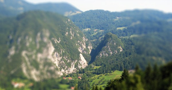
Sotesko Pasice je v svojem srednjem toku v slabo odporen apnenec Malega (758 m) in Velikega Njivca (915 m) izdolbel potok Cerinšcica.
Arhiv Cerkljanskega muzeja.
Za obmocje Malega in Velikega Njivca so znacilna izredno strma, ponekod celo previsna, pobocja. Obmocje soteske Pasice in zaledja Cerinšcice gradijo kamnine razlicnih stopenj stabilnosti, od klasticnih sedimentnih kamnin z vložki crnih apnencev, psevdoziljske formacije skrilavega muljevca in pešcenjakov do apnenca in k plazenju nagnjenih pobocnih sedimentov.

Težko dostopno lego soteske Pasice so partizani med drugo svetovno vojno izkoristili za postavitev kompleksa partizanske bolnišnice z lesenimi barakami in vec pomožnimi objekti. Partizanska bolnica Franja, poimenovana po zdravnici Franji Bojc Bidovec, je na takrat skrivni lokaciji delovala med leti 1943 in 1945.
Bolnico Franja so v preteklosti doletele številne naravne nesrece, od plazov, podorov do poplav. Zaradi intenzivnih padavin septembra 2007 je Cerinšcica, ki ima v normalnih razmerah zelo nizek vodostaj, mocno narasla in poplavni val je odplaknil vecino bolnišnicnih barak in vse mostove. Uniceni so bili podporni zidovi, temelji barak in dostopne poti. V neurju je nastala nepopravljiva škoda tudi na objektih premicne dedišcine. Zbirka predmetov v Bolnici Franji je bila po povodnji mocno okrnjena.
Za varnost pred naravnimi pojavi je poskrbljeno, vendar pa previdnost nikoli ni odvec.
Soteska Pasice ima zaradi svoje nedostopne lege v slovenski zgodovini pomembno vlogo, zato smo mnenja, da mora biti tudi zgodovina del tega zakladka. Le tako lahko obiskovalci razumejo lepoto in moc te soteske, ki predstavlja dve vrlini cloveške narave, humanost in solidarnost.
Obisk Bolnice Franje v obdobju od 1. novembra do 31. marca ni mogoc.
Vse dodatne informacije so dostopne na spletni strani Mestnega muzeja Idrija.
Zaradi poteka steze tik ob vodotoku, osojne lege soteske ter posledicno visoke verjetnosti prisotnosti ledu na stezi je dostop v sotesko v zimskem casu dovoljen le do vrat, ki se nahajajo 100 m od vhoda v samo sotesko.
Vpis v EarthCache tocko ni pogojen z obiskom Partizanske bolnice Franja ampak z obiskom same soteske Pasice.
^ Pojdi na vrh
- Za pozdravno tablo (WAYP1) oceni višino skale, ki je takoj pri mostu preko katerega vodi pot na Porezen.
- Oceni širino in globino struge potoka Cerinšcica pri tocki WAYP2. Tocka se nahaja pri informacijski tabli "Prvo zatocišce"
- Pri vratih (tocka WAYP3) oceni višino od stopnic do dna struge.
- Kolikšno je skupno število barak v Partizanski bolnici Franja? Koliko jih je odnesel poplavni val ob neurju leta 2007?
- Dodatna neobvezna naloga: Fotografirajte se pri eni izmed barak (ce je vstop v Franjo mogoc) ali nekje v soteski.
GPS sprejem je na lokaciji lahko slabši, zato se lahko orientirate tudi s pomocjo informacijskih tabel in slik, naloženih na tej strani.
Ce bo kaj narobe z odgovori, vas bomo kontaktirali.
Ko pošljete e-mail z odgovori, se lahko vpišete v EarthCache tocko.
^ Pojdi na vrh
ENGLISH
About Pasice gorge
This Earthcache is placed on a very active terrain and demonstrates a magnificent and almost stereotypical effect of carving. The Pasice gorge was formed by carving of poorly resistant limestone by stream Cerinscica. The gorge is located between two hills Veliki (915 m) and Mali Njivc (758 m).
Cerkljanski muzej archive.
The slopes of Mali and Veliki Njivc are very steep. Geological structure of Pasice gorge and Cerinscica background area is heterogenous. Rocks that form the area are clastic sedimentary rocks with spots of black limestone, rocks of pseudosilian formation, massive white limestone and scree.
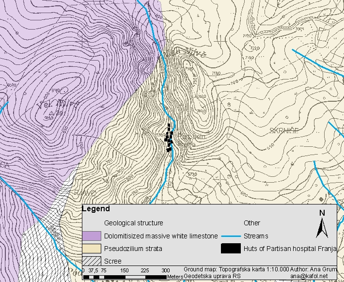
Pasice gorge was during World ward II, because of its difficult accessibility, used for placement of Partisan hospital Franja. The hospital complex, which was named after a female doctor Franja Bojc Bidovec, consisted of wooden huts and multiple auxiliary buildings.
Several natural events like floods, landslides and rockfalls occured affected the gorge in the past. The stream that carved this gorge easily floods the area in times of heavy rain. The stream demolished almost everything in 2007, however in times of normal weather conditions the stream is barely noticeable and could not be thought that it could cause so much damage.
Even though safety of the visitors is well accounted for, you need to take extra caution.
The Pasice gorge holds a very important part in Slovenian history (due to it's geological nature). Here landscape and history go hand in hand. We believe that also the historical part should mentioned in this cache, so that the visitors could fully embrace the beauty and power of the Pasice gorge.
Between 1st of November and 31st of March Partisan hospital Franja is closed for visitors.
Additional information about Partisan Hospital Franja is accessible here.
Even though, a minor section of Pasice gorge is always accessible.
You do not need to enter Partisan hospital Franja in order to complete this EarthCache.
^ Back to top
- Behind the welcoming board (WAYP1) there is a big rock near the bridge over Cerinšcica stream and leads to Porezen. Estimate the height of the rock.
- Estimate the width and depth of the channel of Cerinšcica stream at WAYP2. This waypoint is near the information board "First shelter"
- At WAYP3 by the door estimate the height from the stairs to the bottom of the channel.
- How many wooden huts are there in the Partisan Hospital Franja in total? How many of the huts were completely washed away by floods in 2007?
- Additional (not obligatory) task: take a picture of you at one of the wooden huts (if entrance to the Partisan Hospital Franja in possible). If Partisan Hospital Franja is not accessible, take your picture elsewhere in the gorge.
GPS reception can be poor at the location, so in that case try to orient yourselves with the help of information tables and photos uploaded to this page.
After you send the answers you can log the cache as found.
If your answers are not correct, we will contact you.
^ Back to top