(SI) 17. novembra 2000 je drobirski tok odnesel sedem človeških življenj ter povzročil obsežno opustošenje v Logu pod Mangartom in okolici.
PRED ZACETKOM:
Opis tega Geološkega zaklada je dolg. Prosimo, preberite ga in si zapisite naloge za vpis se pred obiskom zaklada!
NALOGE ZA VPIS OBISKA
Opazujemo lahko več različnih geomorfoloških, reliefnih oblik, oziroma njihovih sprememb, ki so nastale na območju splazitve na Stovžju, območju potovanja toka po dolinah Mangartskega potoka, Predelice in deloma Koritnice ter na območju akumulacije v dolinah Predelice in Koritnice.
Na vprašanji ogovorite na koordinatah Geološkega zaklada, na novem mostu:
1. Ozrite se po strugi Mangartskega potoka navzgor in navzdol. Naštejte nekaj najbolj značilnih reliefnih oblik, ki jih opazite. Nekaj jih je zaradi delovanja drobirskega toka na novo nastalo, ostale pa so bile spremenjene.
2. Oglejte si strugo pod seboj, na obeh straneh mostu. Kje se je erozija drobirskega toka najgloblje zajedla v strugo Mangartskega potoka?
POMEMBNO!
- Preden vpišete obisk zaklada, pošljite odgovore preko GC profila ali neposredno na e-naslov vane.si.geo@gmail.com. Takoj potem lahko vpišete obisk zaklada na spletu – ne potrebujete dodatnega dovoljenja. Ce ste fotografirali, prosimo, priložite kakšno fotografijo.
- Vpisi brez ustrezne spremljajoče e-poste, ki vsebuje pravilne odgovore, bodo najprej trajno kodirani, kasneje izbrisani!
- Vpisi, ki vsebujejo odgovor bodo izbrisani!
Obiščite tudi tradicionalni zaklad v bližini:
Izginula cesta / Missing road (GC3WGB0).
(ENG) At November 17th 2000, the debris flow took the life of seven people and caused an extensive destruction in the village Log pod Mangartom and surroundings.
BEFORE THE BEGINNING:
This EarthCache has a long description! Please, read it and write down logging tasks before visiting the EarthCache site!
LOGGING TASKS
Many different geomorphologic features or landforms caused or changed by the landslide and the debris flow can be observed: in the area of the Stovzje landslide, all along the debris flow path in Mangartski potok and Predelica channels, and in the area of accumulation in the valleys of Predelica and Koritnica streams.
Observe surroundings of EarthCache coordinates and answer questions:
1. Take a look upstream and downstream of Mangartski potok Torrent channel. Write down some of the most typical geomorphologic features or forms. Some have been created by the debris flow and the others changed.
2. Take a look at the channel of Mangartski potok Torrent. Where has the debris flow erosion carved deepest into the channel?
IMPORTANT!
- Send answers through GC profile or directly to e-mail vane.si.geo@gmail.com
before logging. After that you can log - you don't need an additional permission to log. Please, upload photos if you have taken them.
- Logs without an accompanying e-mail containing correct answers will be encrypted and later deleted!
- Logs containing the answer will be deleted!
While you are here, visit the traditional cache:
Izginula cesta / Missing road (GC3WGB0).
slovensko besedilo / Slovenian text
tocke poti in dnevniki / waypoints and logs
Visit our web-site Geološki zakladi / EarthCaches
for a complete list of our EarthCaches and a lot of additional information.
(ENG) DEBRIS FLOW
Debris flows are not very frequent events in the Alps, but since they are usually extensive phenomena, they are still an important factor in the reshaping of the mountain relief – they transport large quantities of material to lower altitudes. Debris flows are often overlooked, occurring in the uninhabited areas. The debris flow of November 2000 has not been unnoticed! It has effectively showed its strength in the populated valley under the Mangart Mountain.
Debris flow is sometimes classified as a phenomena somewhere between landslides and waterflows, another classification define it as a liquefied landslide. It is a flow of unconsolidated, saturated debris. Solid particles, small and large, form 70 to 90 percent of weight and 47 to 77 percent of volume of the flow. Large debris flows are extremely eroding; their frontal lobe can even erode the bedrock and side-slopes of the channel. Eroding and transport power is primarily determined by the content of clay particles. If debris flow contains more than 30% of clay, it could transport large stone blocks. Debris flow density ranges from 2100 to 2400 kg/m3.
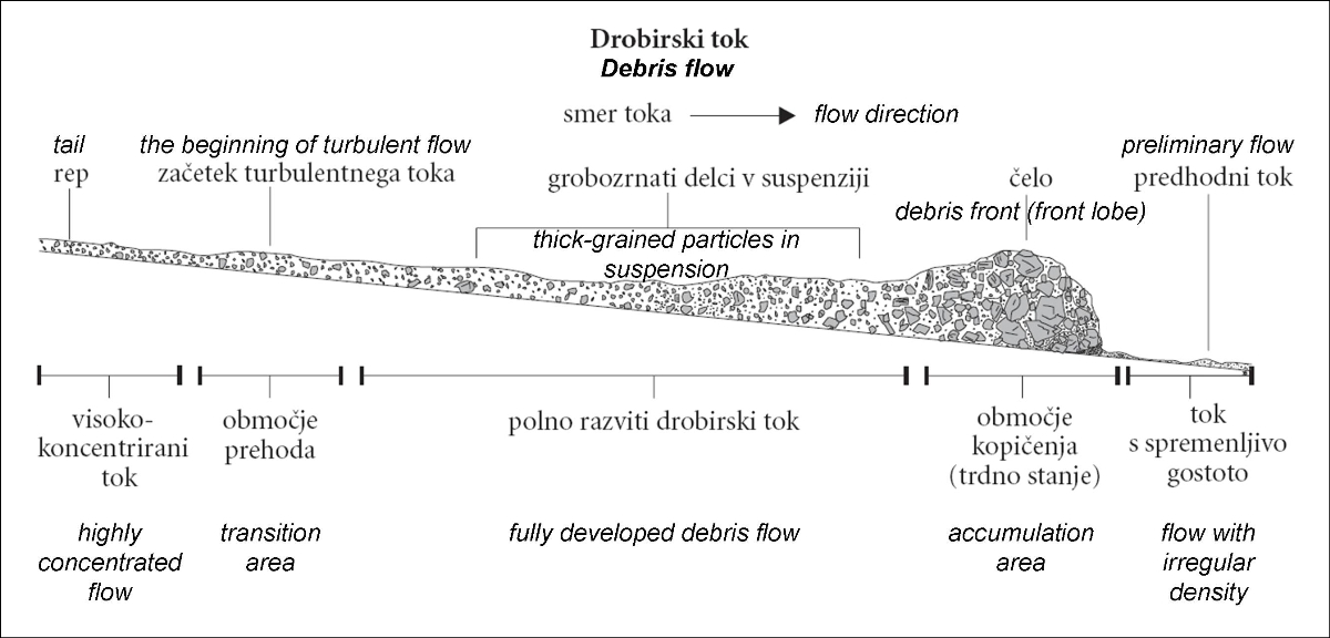
Figure 1: Basic features of the debris flow, according to Ritter et. al. 1995, reference No. 1;
EVENTS OF NOVEMBER 15TH AND 17TH, 2000, LOG POD MAGARTOM VILLAGE
It has all began at November 15th, 2000, in the area called Stenge (stairs), under Stovzje, 1736 m a.s.l., south-west of Mangart Mountain. Landslide and later debris flow, rushed down the Mangartski potok Torrent, destroyed the bridge of the road to Predel pass, and stopped at the confluence of Mangartski potok Torrent and Predelica Torrent. A mass of several 100,000 cubic meters of debris has been about 1.5 km long and several meters thick.
Intensive rain and torrents dammed by the debris have additionally filled the debris mass with large quantities of water. In the rain gauge station in Log pod Mangartom a total of 1638.4 mm rainfall was registered in the 46 preceding days before November 17th, 2000, which corresponds to a return period of over 100 years. In the days from November 14th to 16th alone, 396 mm of rain has been measured!
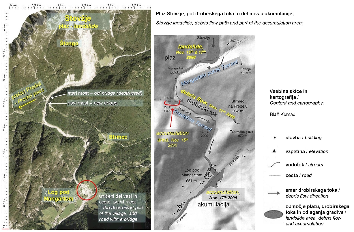
Figure 2a: Landslide and debris flow area: aerial photo 11 years after the disaster, from Atlas okolja (Environmental Atlas of Slovenia), 2011; additional text and markings by vane_si;
Figure 2b: Sketch: Blaz Komac, Anton Melik Geographical Institute, Scientific Research Centre of the Slovenian Academy of Science and Arts, Ljubljana, 2003; additional text and markings in color by vane_si;
In the night from 16th to 17th November 2000 second large landslide occurred. It has reshaped the slope of Stovzje at the altitude 1400 to 1600 m. The saturated mass has transformed into the debris flow, which run down the Mangartski potok Torrent channel, collecting the accumulation of the first debris flow in the process. Debris flow reached Log pod Mangartom village in just a few minutes. It has taken life of seven people in their homes, and destroyed or heavily damaged 26 houses and other buildings. Almost 15 ha of arable land has been covered by debris, deposits reached all the way to Moznica Troughs. Inhabitants have all been temporarily moved from the endangered area. The road to Predel pass has been cut at two places, the bridge crossing Predelica Torrent in Log, and the bridge crossing Magartski potok Torrent have been destroyed. Strmec village has been left inaccessible for some time and Predel reachable from Italian side only.
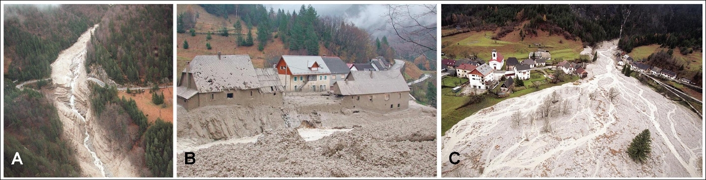
Figure 3: reference No. 5:
A – Mangartski potok Torrent channel has been carved deep by erosion of debris flow; road to Predel pass and bridge destructed by the frontal lobe of debris flow;
B – Destruction in the village Log pod Mangartom;
C – debris flow fan in the village Log pod Mangartom;
More than 1.5 million cubic meters of material has been displaced all together. Part of the mass has been left at the landslide site, while debris flow has taken more than 1 million cubic meters downwards. About 400,000 m3 of material has been deposited along the debris path above Koritnica valley, and about 700,000 m3 at the Koritnica valley bottom. Deposits in the Koritnica valley have reached up to 10 m in height. The debris flow has completely reshaped the landscape in the short time.
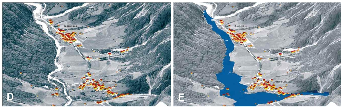
Figure 4: D – Log pod Mangartom before the disaster, and E – after the disaster, November 19th, 2000 (processed by the Slovene Institue for Geodesy; basic data: Surveying and Mapping Authority of the Republic of Slovenia), Bojan Majes, Analysis of Landslide and its Rehabilitation, UJMA, No. 14-15, 2000/2001;
CAUSES OF THE LANDSLIDE AND THE DEBRIS FLOW
The main cause for the landsliding in this area is a geologic structure. In the Upper Triassic (Carnian, cca 220 million years ago), 100 to 200 m of Raibl beds (more precisely Tamar formation) have been deposited above main dolomite. Raibl beds are composed of limestone, marl-limestone, marlstone, and hygroscopic slaty claystone. Everything is covered with thick deposits of glacial moraine material and slope sediments. Rock layers of this area are crossed by two deep faults of alpine direction (north-south). Dolomite of Vrsic hill (neighboring hill of Stovzje) is broken into stone blocks, and water easily reaches lower, less permeable layers through fissures, and springs through Quaternary sediments – glacier moraine and scree.
Previously mentioned slaty claystone is the most important element in the process of landsliding, because it dissolves into the clay. Clay minerals absorb water and swell. Raibl beds are known to frequently cause landslides. Numerous springs at the contact of upper main dolomite and Raibl beds, and steep slope with layers slanted towards south or southeast contributed to the landslide occurrence. But the main triggering factor has been abundant and long-lasting rains.
The landslide has been about 300 m wide, 1.5 km long and up to 50 m deep. It has occurred in the glacial moraine deposits and slope sediments, at the altitude of about 1525 m.
The sediments at Stovzje become liquid with only slight change of the water content, and characteristics of the seemingly solid, dry material change instantly. Stable mass liquefies and material slips and flows as debris flow. A slight slope of only a few degrees is sufficient for the flow, while channel under Mangart alpine meadow has a slant of more than 10 percent.
The debris flow from Stovzje has carried a large quantity of stones and has got a considerable eroding power. But it has mainly not eroded the bedrock, except where it has been weathered. The weathered rock layers have been scraped from the channel bottom and side-slopes, and soil and plant-cover from the slopes as well. The event thoroughly reshaped landscape. Erosion of the cannel-bottom and side accumulation of material have prevailed in the valley of Mangartski potok Torrent above the road to Predel pass. The channel becomes much steeper south of the road, therefore erosion has also been much stronger there and in the Predelica Torrent channel.
REFERENCES
1. Slope processes and the debris flow in Log pod Mangartom, Matija Zorn, Blaz Komac, Anton Melik Geographical Institute, Scientific Research Centre of the Slovenian Academy of Science and Arts,, Geografski vestnik 74-1, 2002, 9-23;
2. Debris flow under Mangart mountain (Drobirski tok pod Mangartom), Blaz Komac, Ekskurzije Slovenskega geografskega drustva, Slovenija, 2002.
3. Geographical Aspects of the Disaster in Log pod Mangartom, Blaz Komac, magazine UJMA, No. 14-15, 2000/2001.
4. Geological Characteristics of the Stoze Landslide, Borut Petkovsek, magazine UJMA, No. 14-15, 2000/2001.
5. Photos:
A and B – from the article “V Logu pod Mangartom plaz odnesel 7 zivljenj” (Landslide has taken 7 lives in the village Log pod Mangartom), photo Igor Modic and Mirko Kunsic, Slovenske novice, May 4th 2011;
C – from the article “Apokalipsa pod Mangartom” (The Apocalypse under Mangart Mountain), magazine Mladina, Nov. 27th 2000;
Slovensko besedilo
Obiščite našo spletno stran Geološki zakladi / EarthCaches
za seznam vseh naših Geoloških zakladov in mnogo dodatnih podatkov.
(SI) DROBIRSKI TOK
Drobirski tokovi so kljub svoji redkosti eden pomembnejših dejavnikov preoblikovanja terena v visokogorju, saj gre običajno za obsežne pojave, v katerih se v nižje lege premesti veliko gradiva. Zaradi odmaknjenosti ponavadi ostanejo neopaženi, jeseni leta 2000, pa je drobirski tok zelo nazorno pokazal svojo moč v naseljeni dolini pod Mangartom.
Drobirski tokovi se praviloma pojavljajo na poslušnih območjih, na vlažnih pa predvsem v gorah. Po dinamiki jih uvrščajo med plazove in vodne tokove, druga razvrstitev pa jih obravnava kot eno od oblik plazov. Drobirski tok vsebuje od 70 do 90 utežnih, oziroma od 47 do 77 prostorninskih odstotkov trdne snovi v obliki večjih ali manjših z vodo premešanih kamninskih delcev in drugega gradiva. Drobirski tok ima zelo veliko erozijsko moč, saj lahko erodira celo dolinsko dno in bregove. Transportno in erozijsko moč določa predvsem vsebnost glinenih primesi. Ce tok vsebuje več kot 30% gline, lahko zaradi velikega notranjega trenja prenaša tudi velike skalne bloke. Specifična gostota drobirskih tokov je med 2100 in 2400 kg/m3.
Slika 1: Temeljne značilnosti drobirskega toka, prirejeno po Ritterju s sod. 1995, vir 1;
LOG POD MANGARTOM, DOGODKI 15. IN 17. NOVEMBRA 2000
Začelo se je 15. novembra 2000, ko se je na območju Šteng pod Stovžjem (1736m), utrgal plaz in kasneje kot drobirski tok stekel po dolini Mangartskega potoka, uničil most na cesti na Predel in se ustavil na sotočju Mangartskega potoka in Predelice (glej sliko 2b). Okrog 1,5 km dolga in več metrov debela gmota je vsebovala nekaj sto tisoč kubičnih metrov gradiva. Na plazišču se je kasneje sprožilo se več manjših plazov.
Gmota v dolini Mangartskega potoka in na pobočju Stovžja se je nato skoraj dva dni napajala z vodo ob obilnih, intenzivnih padavinah. Novembra 2000 je v Logu pod Mangartom padlo 1234 mm padavin, kar je približno polovica letnega povprečja in kar štirikrat več od novembrskega povprečja. Med 14. in 16. novembrom pa so izmerili 396 mm padavin. Plazišče je namakalo več potokov, ki so skupaj z Mangartskim potokom prispevali več kubičnim metrov vode na sekundo.
Slika 2a: Območje plazu in drobirskeg toka: zračni posnetek 11 let po nesreči, iz Atlasa okolja, 2011; dodatno besedilo in oznake: vane_si;
Slika 2b: Skica: Blaz Komac, © Geografski institut Antona Melika, Znanstvenoraziskovalni center SAZU, Ljubljana, 2003; dodatno besedilo in oznake v barvah: vane_si;
V noči s 16. na 17. november 2000, se je sprožil drugi plaz in preoblikoval pobočje Stovžje na višini med 1400 in 1600 m. Namočeni material je kot drobirski tok stekel po dolini Mangartskega potoka in s seboj odnesel tudi gmoto prvega plazu. Drobirski tok je do Loga pod Mangartom potoval le nekaj minut. V vasi je pod seboj pokopal 7 ljudi ter porušil ali hudo poškodoval 26 objektov. Zasutih je bilo 15 ha travnikov in pašnikov, nanos je segal od Loga do korit pri Možnici. Zaradi preteče nevarnosti so prebivalce začasno izselili v Bovec. Na predelski cesti sta bila porušena oba mostova (most čez Predelico v Logu in most čez Mangartski potok), tako da je bil Strmec nekaj časa odrezan od sveta, Predel pa dostopen le z italijanske strani.
Slika 3: A – Zaradi moči drobirskega toka globoko erodirana struga Mangartskega potoka ter unicena cesta in most na cesti proti prelazu Predel; B – Uničenje v Logu pod Mangartom; C – vršaj drobirskega toka v Logu pod Mangartom; vir 5;
Prostornina premaknjenega materiala je znašala več kot 1,5 milijona m3. Del gmote je ostal na plazišču, drobirski tok pa je proti dolini odnesel več kot 1 milijon m3. Na svoji poti do Koritnice je odložil približno 400.000 m3 materiala, na dnu doline Koritnice, pod Logom pa približno 700.000 m3. Debelina nanosa je dosegala tudi 10 m. Drobirski tok je v kratkem času povsem spremenil podobo pokrajine.
Slika 4. D – Log pod Mangartom pred nesrečo in E – po nesreči 19. 11. 2000 (obdelava: Geodetski institut Slovenije, osnovni podatki: Geodetska uprava Republike Slovenije), Bojan Majes, Analiza plazu in možnosti njegove sanacije, UJMA, številka 14-15, 2000/2001;
VZROKI ZA SPLAZITEV IN DROBIRSKI TOK
Poglavitni razlog za plazenje na tem območju je pestra geološka zgradba. V zgornjem triasu (karnij, pred 220 milijoni let) se je na plasti masivnega dolomita odložilo od 100 do 200 m rabeljskih plasti (ali natančneje plasti tamarske formacije), ki jih sestavljajo apnenec, lapornati apnenec, laporovec in higroskopični skrilavi glinavec. Vse skupaj prekrivajo ledeniške morene in pobočni nanosi. Kamnino na tem ozemlju sekata dva močna preloma alpske smeri (sever-jug), ki nista prizadela le laporja in lapornega apnenca, ampak tudi glavni dolomit, ki tvori bližnja vrhova Vršič in Mali Vršič. Zaradi močne tektonike je dolomit v Vršiču razkosan v bloke, po razpokah pa se voda hitro preceja do spodnje ležečih, manj prepustnih plasti in nato izteka na površino skozi kvartarne sedimente - ledeniško moreno in grušč.
Predvsem omenjeni skrilavi glinavec je pomemben za pobočne procese, saj zaradi delovanja vode razpade v glino. Minerali glin vpijajo vodo in ob tem nabrekajo. Rabeljske plasti so znane po pogostih pojavih plazenja, na Stovžju pa so k sprožitvi plazov pripomogli tudi skladna zgradba strmega pobočja (27°) z nagibom proti jugu in jugozahodu ter številni izviri na stiku zgoraj ležečega glavnega dolomita z rabeljskimi plastmi. Poglavitni povod za nastanek drobirskega toka so bile dolgotrajne in obilne padavine. Plaz, ki je bil širok okrog 300 m, dolg 1,5 km in globok do 50 m, je nastal v ledeniški moreni in pobočnih nanosih, na nadmorski višini okrog 1525 m.
Za usedlinsko gradivo na Stovžju je značilno, da postane tekoče ze ob majhni spremembi vsebnosti vode, pri čemer se lahko lastnosti na videz suhega gradiva v trenutku povsem spremenijo. Stabilna gmota postane tekoča in gradivo spolzi ter odteče kot drobirski tok. Za to zadošča že nekajstopinjski naklon terena, pod Mangartsko planino pa je ta večji od 10 odstotkov.
Drobirski tok pod Mangartom je imel zaradi obilice skalovja, ki ga je nosil s seboj, precejšnjo erozijsko moč, vendar kamninske podlage v glavnem ni odnašal. Ta je bila odnesena le tam, kjer je bila kamnina preperela. Tok je z dna dolin in pobočij postrgal preperelo kamnino, prst in rastje ter s tem bistveno spremenil videz pokrajine. V dolini Mangartskega potoka nad predelsko cesto sta prevladali globinska erozija in bočna akumulacija gradiva, na pregibu pod njo, kjer se strmec doline nenadoma poveča, pa je bilo erozijsko delovanje okrepljeno.
VIRI:
1. Pobočni procesi in drobirski tok v Logu pod Mangartom (Slope processes and the debris flow in Log pod Mangartom), Matija Zorn, Blaž Komac, Geografski institut Antona Melika ZRC SAZU, Geografski vestnik 74-1, 2002, 9-23;
2. Drobirski tok pod Mangartom, Blaž Komac, Ekskurzije Slovenskega geografskega društva, Slovenija, 2002.
3. Geografski vidiki nesreče, Geographical Aspects of the Disaster in Log pod Mangartom, Blaž Komac, UJMA, številka 14-15, 2000/2001.
4. Geološke značilnosti plazu, Geological Characteristics of the Stože Landslide, Borut Petkovšek, UJMA, številka 14-15, 2000/2001.
5. Fotografije:
A in B – iz članka V Logu pod Mangartom plaz odnesel 7 življenj, foto Igor Modic in Mirko Kunšič, Slovenske novice, 4.5.2011;
C – iz članka Apokalipsa pod Mangartom, Mladina, 27.11.2000;
tocke poti in dnevniki / waypoints and logs