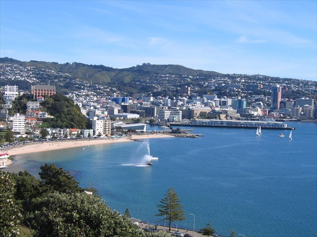
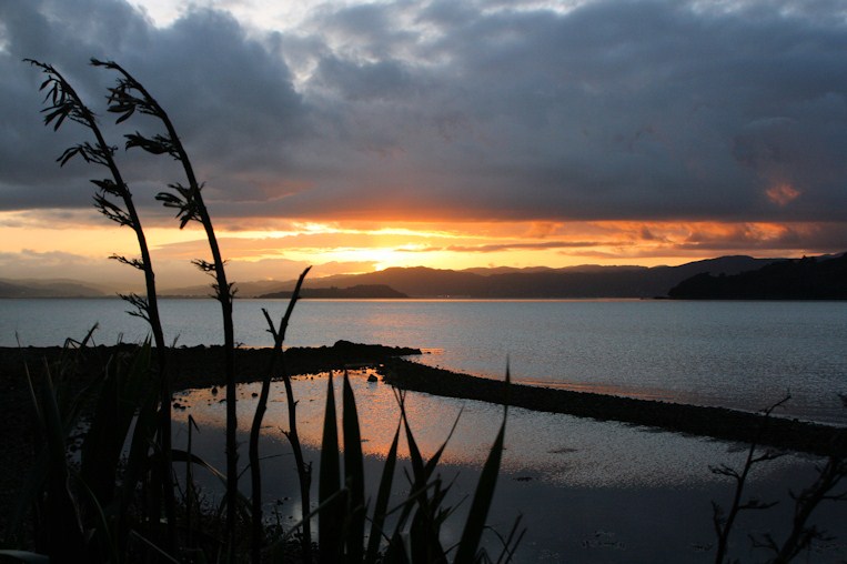
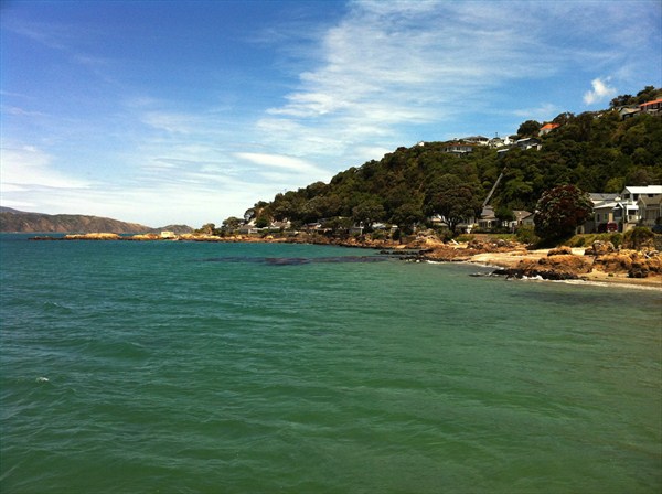
| Looking out over Oriental Bay and Wellington Harbour |
Quick info
Our first cache of 2012. This is a 29-stage multi that works its way around the bays of Wellington starting at Oriental Bay and ending at Owhiro Bay, with the final nearby - documenting the bays and coves of Wellington, and how they formed. It’s a cache that is best done on a bike, as it’s an easy, flat, and scenic ride over gentle terrain. You need to answer 28 questions as you work your way round the bays. There is a checksum for these 28 numbers at the end, but we recommend you read each question before you leave home so you are well prepared.
Geological preface
The geological history of Wellington Harbour is long-winded and complex – dating back many eons, but is primarily of tectonic origin. The oldest basement rocks that make up most of the Wellington region date back to the Permian, Triassic and Jurassic periods, some 280-150 million years ago.
During the Permian period, the earth was dominated by a single supercontinent called ‘Pangaea’. The extensive rainforests of the Carboniferous period had died out, leaving large tracts of desert. Flowers were still over 150 million years down the evolutionary chain. CO2 concentration was 900 ppm (3 times the pre-industrial level), and consequently, the average surface temperature was 2 degrees warmer, and the sea level was 60 metres higher. New Zealand at this time was a long, narrow trough on the sea floor. Over time, the trough filled with sediments. These lighter sediments, combined with three periods of orogeny (mountain-building), formed the mountainous landmass which we live on today.
Wellington Harbour is a continuation of the Hutt Valley. The entire valley is between two tilted blocks. Repeated uplifting along the Wellington Fault raised the block on the western side, creating a cliff along this fault. The block to the east tilted down towards the fault, making a depression, with the lower part later filled with water. Somes Island, Ward Island and the Miramar Peninsula appear to be remnant peaks of a ridge between the fault angle depression and the valley that formed 1.5 million years ago.
But – in geologically recent times, successive earthquakes have been raising the Wellington Region, the harbour included. It originally had two entrances: the present one and a channel where Kilbirnie now lies. The present Miramar Peninsula was an island then. However, successive earthquakes raised the land so high that the channel between Miramar Peninsula and the mainland became only a few metres deep, and rather shallow at low tide – which would have enabled any Maori living in the region at the time to wade across.
This too was short-lived. The profuse outflowing of alluvial sediment from the Hutt River caused the accumulation of silt and sand in the shallow channel, which created a large expansive sandflat, linking Miramar Peninsula to the mainland for the first time in many thousands of years – creating both Evans Bay and Lyall Bay. By the time Captain James Cook explored the area in 1773, only one harbour entrance remained – and he chose not to enter the harbour due to unfavourable winds.
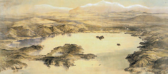
The most striking image of what Wellington Harbour used to look like, a painting by Charles Heaphy, the New Zealand Company draughtsman illustrates the view as he entered the harbour in 1839. The terrain was low-lying, swampy, and marshy. A lake was present on the Miramar Peninsula, Wellington City and the Hutt Valley were marsh lands, the course of the Hutt River was like a delta, and the original Lyall Bay can be seen.
It wasn’t until 1855 – just over 150 years ago, a blink of the eye in geological time – that the harbour acquired its present day outline. At 21:11 on 23 January, a magnitude 8.2 earthquake struck the region, rupturing the Wairarapa Fault and raising the region by up to 6 metres in places. It drained most of the swamps, raised and drastically altered the shoreline, exposing jagged rocks all around the coast. At that point, the present day characteristics of Wellington Harbour formed.
In its 89 km2 area, the harbour holds 1.29 cubic kilometres of water, and ranges in depths from 11 metres to 25.5 metres. The Waiwhetu Aquifer also plays an important role in the hydrology of the harbour, with an estimated daily flow of 113.5 million litres of water seeping through the harbour bed.
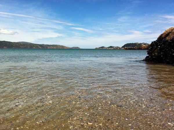 |
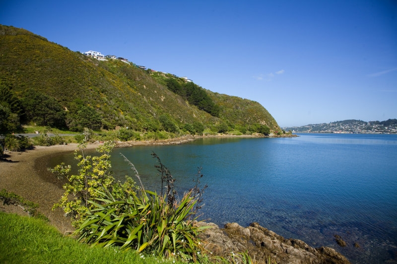
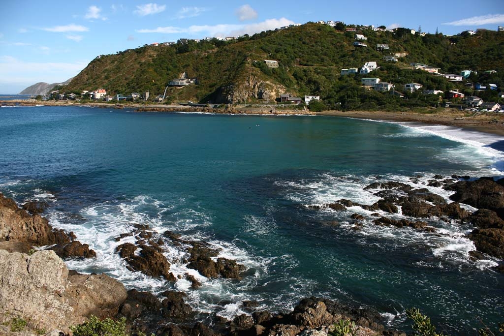
| Looking out to the Cook Strait from nearby Scorching Bay |
Round The Bays geocache
Starting at Oriental Bay and heading around the coast until Owhiro Bay, there are a total of 25 named bays and coves spread over a shoreline distance of 32.9km. We’ve all heard of a few of them, Oriental Bay, Lyall Bay, Island Bay, etc. But some of the most insignificant sections of coastline are in fact also named: Little Karaka Bay, Shark Bay, Eve Bay, Flax Bay, Waitaha Cove. Have you heard of them?
In this 29 stage multi-cache, you will visit each of the 28 waypoints and answer a question there. These waypoints will take you to all the 25 bays and coves. Some of the larger bays have two or three waypoints in them. The best way to complete this cache is by bike; it’s probably quicker on busy days and certainly less frustrating. Kudos to the real cache finders who choose this transport method.
We recommend you read each question before you leave home so you are well prepared. Answer each question en route with care and you shouldn’t have a problem. We’ve assigned each of the waypoints a letter, A-Z, and then α (alpha) and β (beta) for the final two. We are using these to calculate the final coordinates.
In some instances, we will ask you to ‘merge’ the numbers if the initial number is very large. For example, if the number is ‘1327’ its ‘merge’ will be ‘13’ (1+3+2+7) – this is a single merge. If we ask you to ‘double merge’, do it twice, so it would make `1327` into `13` and then into ‘4’ (1+3).
Similarly, if we append ‘careful’ to the end of a question, you may need to be more attentive, as there could be a seemingly obvious but wrong answer. Look carefully for a perhaps obscure but correct answer.
The bays
Oriental Bay
Named after the Oriental, one of the first New Zealand Company ships to bring settlers to the region, Oriental Bay is one of the most popular beaches in Wellington. With its 22,000 tons of champagne-coloured sand that was barged in from Takaka in the South Island, it becomes a hive of activity in the summer. Backed by promenades, walkways and multimillion dollar apartments, it has exclusive amenities found at no other bay in Wellington.
Little Karaka Bay
Little Karaka Bay is the first small open bay directly around from Point Jerningham. It is non-prominent and generally rocky, with small pebbles at its shore. A small gravel bar extends across the bay length, and at low tide can turn the bay into a lagoon.
Balaena Bay
Balaena Bay is the first prominent bay around from Point Jerningham. Sheltered during a northerly, its fine gravel beach is popular with sun bathers. It was at one point used to build boats in Wellington back in the early 20th century.
Weka Bay
Some would hazard at labelling this a bay – it’s more of a curvature in the shoreline than anything else, but a bay it is named. The shore is virtually non-existent now. Evans Bay Parade has encroached so significantly on the coast here that the sea is often up to the seawall. It does however offer good views to the northeast. The prominent south end of the bay is known as Snapper Point.
Kio Bay
Kio Bay is a good example of how human interference can ruin the coastal environment. Very little shore is left due to the infringing seawall, and the beach is full of eroded rubble, cement, asphalt and brick. A lower walkway around the bay does exist, which leads to a set of steps and a seat. A popular windsurfing location during the right winds.
Evans Bay
We’ve all heard of Evans Bay. It bears the name of George Evans, a prominent early settler. The large inlet between Mt Victoria and Miramar Peninsula serves as the glide path for the low-lying Wellington Airport. It hosts a number of cafes, marinas, pieces of artwork, and child bays such as Shark Bay. A slipway for ships was developed on the western side of Evans Bay in the 19th century and was used to repair, maintain and service large ships of the time. The bay was formed due to the alluvial deposits of the Hutt River filling the channel between Miramar Peninsula and the mainland.
Shark Bay
Shark Bay is a gem in the right conditions. It’s quite sheltered. The road backing it (Shelly Bay Road) is not nearly as busy as Evans Bay Parade. There are also no houses, and a promenade of pōhutukawa trees lines the bank. This slightly rocky beach is a good place to launch a kayak.
Shelly Bay
Made up of 3 smaller baylets, Shelly Bay was owned by the New Zealand Defence Force for 124 years until 2009, and as such has been heavily industrialized. Some natural shore remains, and it is still popular with divers, but it is not as pristine as some of the others in the area.
Kau Bay
This bay is the northernmost on the eastern side of Miramar Peninsula, and is in between Point Halswell to the north and Kau Point to the south. Its large expansive, rocky foreshore turns to silt underwater. A dip in the sea floor at the southern end of the bay measures 25.5 metres. A tyre reef can be found 8-10 metres out at the southern end.
Mahanga Bay
Mostly sheltered, it was the home of an old wharf – that used to jut out from what is now the parking. It was demolished in 1962 with explosives. A popular dive site, it also serves as an experimental mussel aquaculture facility. Further out strong tides are present.
Scorching Bay
What a difference a single bay makes. Scorching Bay’s wide, sandy and gently sloping shore with white-gold sand, makes it a magnet for bathers and visitors. There are parking, changing rooms, running fresh water, and a large grassy lawn. Beneath the surface, it has a clean, sandy bed with good visibility that slopes gently off to a depth of 13 metres. A great spot in a northerly, not so great in a southerly.
Karaka Bay
Not really a bay in its own right, but more of a continuation of Scorching Bay. Its shore is mostly rocky with pōhutukawas lining the edge. A small jetty juts out into the bay.
Worser Bay
A large, open-ended, sandy bay with a nice beach, Worser is not the most sheltered of places in a northerly or a southeasterly, but is still a popular destination nonetheless. A surf club is established here, and dunes back the beach. It is the last of the calm water bays, as the water here is within the natural harbour boundary.
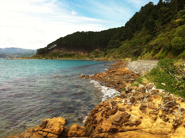
Breaker Bay
The first of three good surfing beaches on the southern Wellington coast. It has a coarse sand beach, and is protected from the harbour entrance by the Point Dorset reef. The depth steadily drops off into the bay to 11 metres, and visibility is most often affected by southerly swells. It is named for the southerly swells that break on its exposed coastline.
Eve Bay, Flax Bay, Reef Bay
Moving south around the peninsula from Breaker Bay, a set of three small rocky bays can be found – bearing the names of Eve, Flax and Reef. They’re all very small with many rocks at the ends of each. They all offer good views out to the harbour entrance.
Palmer Bay
The most ridiculous, tiny ‘bay’ we’ve ever heard of. We aren’t sure how this earned the title of ‘bay’ – it’s simply a stretch of coastline with a slight inward curve. Above on the hills is Atatürk Memorial, and across into the harbour entrance is Barrett Reef.
Tarakena Bay
The easternmost bay on the southern coastline of Wellington, it is relatively sheltered considering its location, protected by Palmer Head to the east and Moa Point to the west.
Lyall Bay
Formed by the alluvial deposits of the Hutt River filling the channel between Miramar Peninsula and the mainland, the unsurprisingly sandy Lyall Bay is one of the most well-known bays in Wellington, with its sparse, flat beaches and good surf, which makes it extremely popular. It is now only two-thirds of its original size however, as the development of Wellington Airport in the 1970’s took a chunk out of the eastern portion of the bay. The three waypoints we bring you to here highlight this.
Waitaha Cove
Waitaha Cove is a very small, rocky baylet to the far west end of Lyall Bay. Te Raekaihau Point lies to the south of the cove, and flanking either side of the cove are carparks. Covered in seaweed, the seafloor and beach are less desirable than others.
Princess Bay
Princess Bay is the smaller child bay of the much larger Houghton Bay, and is the sandy beach on the eastern side. The yellow triangle nearby marks the beginning of the 854-hectare Taputeranga Marine Reserve, so all marine life is protected and cannot be removed. The bay has good facilities, and is a popular spot to go diving as it is sheltered from direct swells, but is still subject to silting from waves entering Houghton Bay. The bottom area in Princess Bay is weedy close to rocks on the southeastern side, and a mix of gravel and sand is in the bay. A nice reef extends out across the entrance to Houghton Bay. Diving south from the car park entry points, there are beautiful rocky reefs and large open gravel plains.
Houghton Bay
Houghton Bay is a popular coarse-sandy beach with a regular population of surfers. It has a good swell, and beneath the surface a great clear sandy bottom. Due to low levels of light pollution, the Aurora Australis (Southern Lights) can sometimes be seen from this spot. Like Princess Bay, it is also within the Taputeranga Marine Reserve.
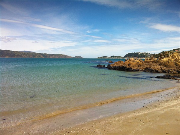
Island Bay
Island Bay is so named for Taputeranga Island, which dominates the area and lies just off the coast of the bay. The island somewhat shelters the bay from large swells, so it is popular with swimmers who appreciate its clear water and clean seabed. It is also the centre of Island Bay’s fishing community, with scores of boats moored in 10 metre deep water just offshore in the bay.
Owhiro Bay
The final named bay along the southern coast in Wellington, Owhiro translates to ‘moon on the first night of the lunar month’. It hosts its own community much like Island Bay, but the bay is smaller and further in. It has a number of good diving spots, as it gently slopes to 13 metres into the Cook Strait. There are four shipwrecks accessible from the site, the Yung Pen which has barely a metre of water of it at low tide, the Cyrus for which there are no obvious remains, the Wellington and the Progress.
Calculations and the final cache
Congratulations, you’ve travelled round the bays and now have the necessary 28 values ready to locate the final. The checksum of A-β is 506. Yes, that is correct. The cache can be found at:
S 41° ab.cde
E 174° fg.hij
Note the use of lowercase letters, they are distinguished from the waypoint answers which are uppercase and Greek letters.
a = (A + B + C + D) / H
b = (E + F + G + H) and then subtract second digit from first digit
c = (Q – R) + O
d = using the digits of S and T, subtract the three smallest digits from the largest
e = (U + V) and then divide the smaller digit into the larger digit
f = (I + J + K + L), then subtract the smaller digit from the larger digit
g = (M + N + O + P) / (0.5 * H)
h = using the digits of W and X, create a descending sequence and supply the missing digit
i = add together the digits of Y and Z
j = The square of the difference between α and β
The checksum of a-j is 45. Good luck!
Update 2024-03-17: Final moved by the following additional offset adjustments to the above calculated coordinates: S +0.022 E -0.041