Liberty Park - Twinsburg Ledges and "Living Skin"! EarthCache
Liberty Park - Twinsburg Ledges and "Living Skin"!
-
Difficulty:
-

-
Terrain:
-

Size:  (not chosen)
Please note Use of geocaching.com services is subject to the terms and conditions
in our disclaimer.
A Big Congrats to "Muddy Dawgs" for being Liberty Park's FTF!!
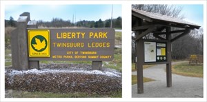
Welcome to "Liberty Park" - Twinsburg Ledges", a part of the Metro Parks, Serving Summit County, located in Twinsburg Ohio, just off of Liberty Road. This is a gem of Mother Nature's, with its luscious green ferns and moss placed breathtakingly over the rocks and ledges.
Please read and follow all instructions for the WNS (White-nose Syndrome) posted on the signs at Liberty Park as well as the WNS information and "Note" listed below on this EC page.
Many thanks go out to the Metro Parks of Summit County for giving permission to place this Earth Cache and for sharing the Akron University's '09 Northeast Ohio Metro Parks cave research information.
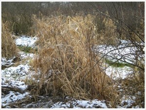
Please note, that the images shown on this EC page were taken in late December of 2011 and depict only a fraction of the green vegetation that this area offers during the spring and summer months. This parks is only open from dawn till dusk, and please follow all posted park regulations. Please stay ONLY on the trails and do not go beyond the "Conservation Area" signs. We would not what any of this beautiful vegetation damaged.
It is highly suggested to bring "MUD BOOTS", especially after a good rain or when the snow has melted. Don't forget that there is a Naturalist stationed at the old stone Metro Parks house just up the hill (traveling south), near the ball fields at 9207 Liberty Road. You can see Liberty Park and other area Metro Parks hiking and event schedules at: www.summitmetroparks.org
A word of caution, there is a very small chance that you will spot a black bear or a coyote during your visit at Liberty Park. If you do, there is a phone number for "Animal Sitings", posted on the Metro Parks sign in the parking lot.
Obviously, there aren't any caches permitted in this park, so to earn your smiley you'll need to answer the three geological questions listed below. Please do NOT post your answers as you log your visit. Simply email me your answers within seven days, so that your smiley remains valid.
First question: Find where the elevation reading is on your GPS, then walk to the coords named "Top Elevation" (REF1) at the beginning trail sign. Write down the "Top Elevation" reading and then proceed down the trail to the coords named "Glacier Cave Lower Elevation", at the cave sign (REF2). Take a second "Lower Elevation" reading there and then subtract the "Lower Elevation" from the "Top Elevation" starting point reading. Email me the difference between the two measurements. This measurement will tell you the "thickness/height" of how much sandstone was eroded away by the scraping glacier, which also created "Glacier Cave" at this location of Liberty Park. Please do NOT climb the ledges to obtain your measurement readings. We know all GPS's are not created equal, your answer can be within six feet and the readings must come from your GPS/Elevation device.
Second question: Please do NOT walk into "Glacier Cave", they are closed indefinitely. Observe the "streambed" that runs out of the cave by staying on the trail. No need to take a sample but just look through the water and past the quartz pebbles and dirt. What "one word" best describes the granular material and mineral particles at the bottom streambed?
Third question: Ignoring the rainfall since the time of the glaciers, yes or no, do you think this is the same "stream" that was left when the glacier melted? Hint: the answer to the second question is the reason to determine the third question. Again, please do NOT log your answers on this page, just simply email them to me within seven days of registering for this EC.

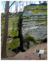
The History: "Glacier Cave" and the ledges at Liberty Park are developed in a layer of bedrock called the Sharon Conglomerate. This rock unit is made of sand and small quartz pebbles carried by fast-moving primeval streams in the Pennsylvanian period, about 300 million years ago. Although the rock is quite old, the caves themselves are likely much younger. They probably formed during and after glaciations of the Pleistocene Epoch, a few million years ago at most, and maybe only a few tens of thousands . The pebbly sandstone resisted weathering, but the less resistant rock layers beneath eroded away. The base of support for the massive Sharon Conglomerate layer is weak. This, along with the action of glaciers, promoted fractures in the rock, forming ledges on the hillsides and deposits of huge blocks of rock at the base of the cliffs. Subsequent weathering of the bedrock by groundwater developed caves such as Glacier.
Rock shelters and crevices are two slightly different types of caves. The term "Rock Shelter" is often used for caves that do not have a "dark zone" and were used by Native American's for temporary shelters. An example is "Mary Campbell Cave", found in Gorge Metro Park (Cuyahoga Falls). The other type, "Crevice Caves" are formed from splits in the rock or calving of a rock surfaces, also without a dark zone.
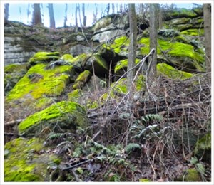
One of the most amazing points of interest here at Liberty Park is its' year-round "Living Skin" (REF3). The two most common types of vegetation that thrive on the rocks and ledges are ferns and moss. This task is "OPTIONAL", if you wish to upload an image or two of your favorite "Living Skin" photos including a brief caption that best describes your thoughts of the image you took.
A second point of interest is the Liberty Park's wetlands (REF4), which help to purify the rainwater and provide wildlife protection. Many frogs, turtles, birds and other types of animals make these wetlands their home.
Just a word of caution: please be very careful on the boardwalk when it is wet or icy. You know what a pirate says, it's slipperier than a mermaid's tail. Hope you have a great experience at the Metro Parks "Liberty Park - Ledges" and please use caution when hiking over the rocky areas. Happy Caching!
Additional Hints
(Decrypt)
Gunax lbh sbe cenpgvpvat PVGB!