Introduction
The Global Positioning System (GPS) is the heart of this hobby we call geocaching. As such, I thought it would be good to learn a little something about it, maybe even see if I could understand how it all worked. On a very basic level the GPS is a trilateration system. In trilateration, a point location can be found given known distances from other known points. The known radii can be drawn as circles around those points and the intersection of the circles is your location. Seems simple enough. The GPS is the same thing, except distances are computed based upon the time it takes a signal to travel from a satellite to your receiver. Things get vastly more complex the more you learn about the system, but one concept that I found particularly interesting was how you can get atomic clock accuracy on your GPSr without having an actual atomic clock.
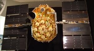 GPS Satellite |
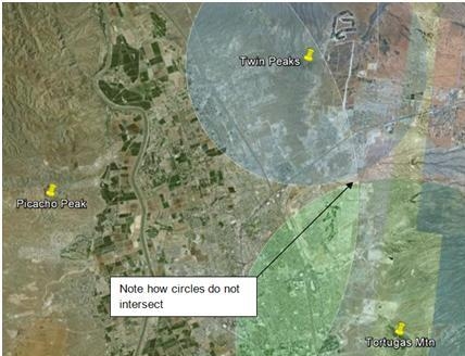
Computing the distance between a satellite and your GPSr requires 2 pieces of information, the speed of light and the time it took between the objects. GPS satellites are built with very expensive atomic clocks which are so accurate that they will not gain a second of time in 138 million years. Your GPSr on the other hand has a simple quartz clock. Obviously this makes your device affordable, but it is not nearly as accurate. That tiny bit of inaccuracy when multiplied by the ultra fast speed of light translates into a pretty significant error. If you were to draw circles around all the known points based upon these distances, you would see that they probably do not intersect at a single location. |
Fortunately, there is a way around this inaccuracy otherwise our GPSr units wouldn’t be very useful for geocaching. Note that if your GPSr had the accuracy of an atomic clock, then you would get a very accurate location. What your GPSr can do is make tiny changes to its own clock and determine how that effects the location accuracy. As the time in your device gets closer to the “true” time that would be held by an atomic clock, the location accuracy improves. Eventually, the result is your GPSr is synced up to the atomic clock time and you get a read out of the location that is accurate to a few meters. Nice work GPSr!
The Las Cruces Positioning System (LCPS)
I hid this cache using a hypothetical positioning system which I will dub the “Las Cruces Positioning System” or LCPS. The LCPS has 3 transmitters at the following locations (in UTM):
| Station |
Easting [m] |
Northing [m] |
| Picacho Peak |
13S 322866.09 |
3578891.07 |
| Tortugas Mtn |
13S 340125.44 |
3574170.44 |
| Twin Peaks |
13S 334367.33 |
3586659.56 |
Each transmitter sends out a signal containing data pertaining to when the signal is transmitted with atomic clock accuracy, and also its own identity so that my LCPSr can determine where the signal originated. My LCPSr device is tuned to recognize these signals and at any given moment can determine the transmission times of all three locations at my location. Since the transmission times are all very close to each other (less than a millisecond) I do not bother to record the day, hour, minutes, seconds. At the cache location the transmission times for each station are:
| Station |
Transmission Time |
| Picacho Peak |
0.35895054212305 |
| Tortugas Mtn |
0.35897427785526 |
| Twin Peaks |
0.35898065327807 |
My LCPSr clock is accurate to the microsecond and received each of the above transmissions at 0.359000 seconds. There is now enough information to accurately determine the coordinates of the cache.
Guidelines for solving
Finding the cache coordinates given the above information involves problem solving and math skills. I realize that different approaches can be used, and may yield slightly different results depending on rounding errors, number of calculations etc... To help you arrive at the same solution that I did here are some guidelines:
- Assume the speed of light is 299,792,458 meters per second.
- Minimize unit conversions, keep coordinates in UTM and use meters for distances.
- Only use 2-dimensions, assuming the area is a flat surface and the UTM coordinates define a grid. (3-dimensions makes the problem a lot more difficult and I didn’t want to go there).
- Avoid rounding, use lots of significant figures in all your computations.
The cache is a well camouflaged micro to discourage people finding it without getting a close solution. I hope this mental exercise will leave you with a new appreciation of your GPSr, and the GPS as a whole.
