The Pipeline is the approximately 15 km long
water supply system that was used by the pulp and paper mill
located in the city of Miramichi. Even though the mill was located
beside the Miramichi River the salt content of the main branch of
the river was too high for the paper making process so water had to
be pumped from one of the tributaries further up the river
system.
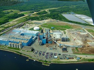
The announced closure of the mill by UPM-Kymmene on December 17,
2007, marked the end of an era which began in 1948 when the Fraser
Company built a kraft mill on the site of the former Sinclair
sawmill.
In 1965 the company added a bleachplant to the mill to whiten
the kraft. This process required a larger amount of water than the
Mill Stream dam (the water supply system at that time) could
provide so the mill created the pipeline off the Southwest
Miramichi River in Bryenton. Initially both waterlines were used
until the Mill Stream system was dismantled.
The pipes from this Bryenton pump house are made of wood soaked
in creosote and held together with metal bands. Their diameter
measures 42 inches compared to the previous 16 inch diameter pipes
from the Mill Stream pump house. The water is pumped uphill to a
reservoir and then gravity fed the rest of the way downhill to the
mill. The small numbered buildings along the way were used to
‘bleed the lines’ (remove air bubbles). Inside each of
these building is equipment that looks a lot like a fire
hydrant.
The pipe is actually above the ground for a short section at the
‘Bear Den’ which is a deep ravine area in Millerton.
This section of the pipe is made of metal, has the same 42 inch
diameter and is wrapped in insulation.
Before reaching the mill the pipeline crosses the Northwest
Miramichi River. When placed in the river the line was initially
the wooden creosote pipe but this was later replaced with more
environmentally friendly PVC pipes. The line was initially floated
on top of the water until it was in place and then small
simultaneous charges (explosives) destroyed the floatation devices
allowing the line to sink to the bottom. Barges of gravel were then
used to cover it.
When the mill was in operation an employee checked the pump
house and drove the 15 km line daily between the pump house and the
mill. Now that the mill is shut down the pipeline (which is what
the locals call the road that follows the pipeline) is no longer
plowed during the winter months. The snowmobile club used (and is
still using the road) as a connection to the trail system in
Quarryville and in the summer the road is hard packed and
accessible to most vehicles.
The cache contains a log and the usual swag but no pencil so you
will have to bring one. There is a micro geocoin for the first to
find.