What is an Oxbow? It is a sharp, U-shaped bend in a river, creek, or stream. The bend is so sharp that only a narrow neck of land is left between the two parts of the river.
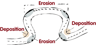
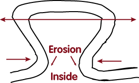
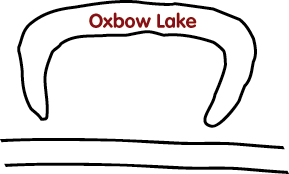
What is an Oxbow Lake? An oxbow lake is formed when a river creates a meander, due to the river's eroding the bank through hydraulic action and abrasion/corrosion. After a long period of time, the meander becomes very curved, and eventually the neck of the meander will touch the opposite side and the river will cut through the neck, cutting off the meander to form the oxbow lake. This process can occur over a time scale from a few years to several decades and may sometimes become essentially static. During heavy floods and the rainy seasons the Oxbow will form at a much faster rate. During the creation of the Oxbow lake erosion is occurring is several points along the river where you will notice larger rocks or stones that appear. There will also be point where deposits are taking place. In this spot you will notice more clay and fine sands. You may also notice the water flow is more vigorous at the points of erosion than at the deposit locations.
There is a similar Earthcache created by Muddy Buddies just south of Houston in Brazos Bend State Park OxBow at Hale Lake GC1MMZ6. That particular Earthcache is of a completed Oxbow Lake.
How is it created?
You can see how an oxbow lake takes shape below:
(1) On the inside of the loop, the river travels more
slowly leading to deposition of silt.

(2) Meanwhile water on the outside edges tends to flow faster, which erodes the banks making the meander even wider.

(3) Over time the loop of the meander widens until the neck vanishes altogether.
(4) Then the meander is removed from the river's current and the horseshoe shaped oxbow lake is formed.

Without a current to move the water along, sediment builds up along the banks and fills in the lake.
Aerial View of Buffalo Bayou Oxbow

Logging Requirements: Now, you have learned what makes an oxbow lake.
Here are the logging requirements. To log this cache, you must answer the following questions and complete a few small task. Email me the answers. Please do not post this is your log.
1. Where is the Buffalo Bayou Oxbow in the process? Make an educated guess as to how long it will take the Oxbow to become a lake.
2. A. From the coordinates of the cache how far down is it to the water?
B. Do you think with more water in the Bayou the Oxbow will form faster?
3. For the following question you need to know the Bayou flows West to East.
A. When viewing the Bayou from Waypoint 1 (which is the beginning of the oxbow)what side of the bayou does the river tend to meander to? North or South? Please describe which side (North or South) has the deposits and which side has the erosion. Describe what you see.
B. At Waypoint 2 (which is the end)what side of the bayou does the river tend to meander to? North or South? Please describe which side (North or South) has the deposits and which side has the erosion. Describe what you see.
4. Take a picture of yourself, with your GPSr, with your back to the bayou. Please post this picture with your log. (This is not required)
Please do not log your find until email or a message with the requested proof of visit has been sent. Found logs without a corresponding email or message will be deleted without further warning.

Web Counter
Congratulations to Criffree for FTF!