About 367 million years ago an object from space splashed down into the Devonian sea that bordered western North America, almost instantly blanketing much of southern Nevada and surrounding areas. Now known as the Alamo Impact. The event resulted in one of the best-exposed and well-dated impact deposits and a full-scale physical model for understanding wet (water) impacts: The Alamo Breccia.
Breccia is a rock composed of broken fragments of minerals or rock cemented/fused together by a fine-grained matrix that can be either similar to or different from the composition of the fragments.
Impact Breccia forms during the process of impact cratering when large meteorites or comets impact with the Earth or other rocky planets or asteroids. Breccia of this type may be present on or beneath the floor of the crater, in the rim, or in the ejecta expelled beyond the crater.
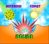 Bolide
What is a bolide? It's an extraterrestrial body in the 1-5 mile size range, which impacts the earth at velocities literally faster than a speeding bullet. explodes upon impact, and creates a large crater. Bolide is a generic term, used to imply that we do not know the precise nature of the impacting body, whether it is a rocky or metallic asteroid, or an icy comet, for example.
The Alamo bolide impact occurred 367 million years ago, when one or more hypervelocity objects from space slammed into shallow marine waters at a site that is now the Devonian Guilmette Formation of the Worthington Mountains. The event is named for breccias of metamorphosed crushed rock deposits, found at the town of Alamo, Nevada (the Alamo Breccia).
This catastrophic impact event resulted in one of the best-exposed and most accurately dated impact events. It occurred within the Frasnian Age of the Devonian at about 367 Ma, a moment in time that was about 3.5 Ma prior to the Frasnian/Famennian extinction events, which it is unlikely to have affected.
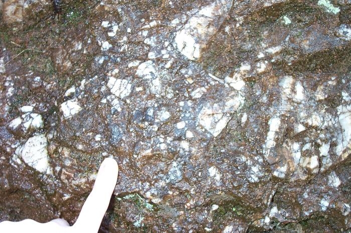
 Alamo Breccia (polished)
The Alamo Impact Breccia is near Hancock Summit, Pahranagat Range, Nevada. The actual impact site has not yet been precisely documented—even its exact diameter and its internal structural features are not yet clear enough to make speculations on the object's mass and trajectory genuinely useful. The tectonic overprint, the subsequent geologic modifications since the event, have distorted the picture; the distribution of the breccia has been compressed and skewed by west-to-east thrust faults across the area. Insufficient detail does not permit a precise reconstruction of the Devonian paleogeography, beyond the fact that it was a "wet-target" impact in a reef front where carbonates were being built up in marine shallows.
The impact site contains megabreccia of gigantic displaced blocks, together with several attributes familiar from other impact sites: shocked quartz, elevated iridium levels, and spherical lapilli. Geologists who first recognized the geologic anomalies as the results of a bolide estimates that the total volume of limestone reef deposits and bedrock that was smashed, deformed, partially melted or shifted during the Alamo event at 1,000 cubic kilometers. Ensuing tsunamis rearranged much of the debris.
______________________________________________________
Where is the Alamo Breccia? The coordinates will take you to a roadside marker at a mountain pass along Hwy 375 twelve miles NW of the tiny town of Alamo, NV. The location of the breccia is indicated by an arrow on the image below (right).
It is not necessary to climb the mountain, the waypoint is a roadside marker.

 Hwy 375 sign, Breccia at arrow-indicated area near, Hancock Summit
_______________________________________________
Photos are welcome, but none are required.
However, to demonstrate the educational value of the Earthcache, please email answers to the following questions to ARF! at the link below:
1. What geological feature is breccia?
2. Distribution of the breccia has been compressed and skewed by what?
3. What existed here 367 million years ago?
4. What effect did this event have on the dinosaurs?
5. MUST ANSWER What sign is posted here? (proves you were here, don't post a pic of it).
Please email answers to:
ARF!
The ET Earthcache series include the most FAVORITED Earthcaches in Nevada! Thanks to everyone who posts a
FAVORITE
_____________________________
Alamo to Tonopah Earthcaches:
Groom Mining District Rachel, NV (GC2GHE8)
Alamo Breccia Alamo, NV (GC37ZKW)
Playa Goblin Knobs, NV (GC2GP44)
Walker Lane Tonopah, NV (GC36DRD)
Golden Arrow Mine Golden Arrow, NV (GC4QX9J)
______________________________
Please do not wait on a reply from me. Simply email the answers and log the Earthcache.
Logs which do not meet requirements will be quietly removed.
______________________________________________________