Billabong?? or Oxbow?? EarthCache
-
Difficulty:
-

-
Terrain:
-

Size:  (other)
Please note Use of geocaching.com services is subject to the terms and conditions
in our disclaimer.
Is it a "Billabong" or is it an "Oxbow"?? Actually, it is both but it depends where you come from. Canadians will call this an Oxbow Lake" but the Australians will call it a "Billabong".

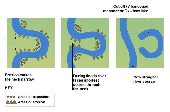
An Oxbow lake is a crescent-shaped land formation usually caused by flowing water of a stream or river. A steam will flow in the direction of least resistance and will start to meander. Deposition occurs on the convex bank (the smaller radius). Lateral erosion and undercutting occur on the concave bank (the greater radius.) The continuous deposition on the convex bank and erosion of the concave bank of a meandering river causes the formation of a very pronounced meander with two concave banks getting closer. The narrow neck of land between the two neighboring concave banks is finally cut through, either by lateral erosion of the two concave banks or by the strong currents of a flood. When this happens, a new straighter river channel is created thus cutting off the meandering loop. When deposition finally seals off the cutoff from the river channel, an Oxbow lake is formed. The process occurs over a time scale from a few years to several decades.
An animation of a meandering stream forming an Oxbow can be seen at HERE
Go to the posted coordinates and you will be able to see how the Boggy Creek formed an Oxbow. Depending upon the time of the year this Oxbow may or may not have water in it. If you venture further West along the stream, you may observe more Oxbows.
The Condie Nature Refuge Area is used as a recreational site for hiking and observing nature. Enjoy all the wild life you may see in this area. The deer, beaver, muskrats, ducks, geese, birds, and rabbits roam this area, and yes, if you are lucky, you may even see pheasants or a moose. This Refuge area is "closed from sunset to sunrise". Dogs are not allowed in the refuge area.
LOGGING REQUIREMENTS
Do NOT post your answers in your log. Please be sure to submit your answers to me or your log will be deleted.
To log this EarthCache one must submit to me through my profile the answers to the following questions:
1. On first line, give me the name of the earthcache, the GC code, and your caching name(s).
2. What is the distance of this Oxbow at its greatest length (Points "A" to "B" in the measurement illustration) and what is the distance between the 2 ends of the Oxbow that was cut off from the stream (Points "C" to "D" in the measurement illustration)?
3. Notice the size of this Oxbow. Would you consider this to be a large or a small Oxbow. Explain the rationale for your decision. Where else on your travels do you recall seeing Oxbows?
4. Take an elevation reading at the posted coordinates. Go to the top of the earth dam behind you and take another elevation reading. What is the height of this dam??
5. (Optional) Please post a photo of your GPS unit with the Oxbow in the background.
Use this illustration on how to take your measurements of the Oxbow.

Additional Hints
(No hints available.)