Earthcaches are cool, just think and cache them ;))
)")
Credits & permits: Dziękuję dyrekcji Wigierskiego Parku Narodowego, za możliwość założenia earthcachea na terenie WPN. Zakładanie keszy na terenie WPN wymaga każdorazowo zgody dyrekcji Parku.
Thanks to Wigry National Park’s staff for permitting me to place the earthcache in the area of WNP.
Placing caches in the area of National Park requires the Park’s staff permission.
I dedicate this earthcache to my special friend,
Yuriko. 非常感谢 for all your English earthcache-translations! One day you should see this one Suchar, Y ;)

Suchary to polodowcowe jeziora, stanowiące najliczniejszą grupę zbiorników wodnych na terenie Wigierskiego Parku Narodowego. Nazwa suchar jest określeniem regionalnym, typowym dla terenu Suwalszczyzny. Niektóre źródła twierdzą, że wywodzi się ona od częstego występowania na brzegach takich jezior obumarłych, suchych drzew.
Największym z osiemnastu sucharów na terenie WPN jest Suchar Wielki (8.9 ha), nad którym właśnie stoisz. Jeziora te powstały w wyniku działania lądolodu, który podczas regresji - ustępowania lodu - ukształtował charakterystyczny suwalski krajobraz. Większe zagłębienia, jakie lądolód odcisnął w podłożu, wypełniły się wypływającymi z czoła i szczelin gigantycznego lodowca wodami tworząc większość dużych jezior. Suchary, jako zbiorniki o wysokim stopniu izolacji - brak przepływu powierzchniowego i podziemnego czy połączenia z innymi jeziorami - są pozostałością po wytopieniu się tzw. martwego lodu. Terminem tym określa się zarówno oderwane bryły jak i odizolowane od głównego lądolodu potężne języki lodu. Często martwy lód pokrywała powtórnie warstwa osadów akumulacyjnych podczas krótkotrwałego nawrotu lądolodu i ruchu wytapianych z niego wód. Czasem lodowiec nasuwał się na ukryty w ten sposób martwy lód, wgniatając go ziemię, co powodowało jego bardzo powolne wytapianie i tworzenie się czasami dopiero kilkaset lat później, kiedy polodowcowa tundra porosła lasami, tych typowych leśnych oczek.
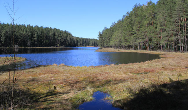 Suchar Wielki / Photo & Backgroundphoto by Hanbei
Suchary są zbiornikami o niskiej żyzności. Ich woda zawiera duże ilości kwasów humusowych - substancji organicznych powstających z rozkładu igieł, liści, ściółki, spłukiwanych z otaczających je lasów iglastych. Substancje te nadają wodzie specyficzne, brunatne zabarwienie, zmniejszają jej przejrzystość i powodują zakwaszenie.
W sucharach brak jest roślinności wodnej charakterystycznej dla większości jezior - przybrzeżnych szuwarów oraz łąk podwodnych. Wokół typowego suchara występuje tzw. pło, czyli nasuwający się od lądu w kierunku środka zbiornika kożuch roślinny. Budują go m.in.: mchy torfowce, żurawina, modrzewnica, przygiełka biała, turzyca bagienna, bagno zwyczajne. Pło jest również miejscem licznego występowania roślin owadożernych: rosiczki okrągłolistnej i długolistnej. Rośliny te pełnią specyficzną funkcję ekologiczną - wzbogacają strefę pła w substancje odżywcze (głównie fosfor) pochodzące z rozkładu schwytanych owadów i innych drobnych zwierząt.
Suchary otacza zazwyczaj wysokopienny bór, osłaniający te jeziora przed wiatrem i zacieniający ich powierzchnię. Wpływa to na bardzo słabe mieszanie wody, czego skutkiem jest wręcz wyróżniającą ten typ jezior bardzo silna stratyfikacja termiczna wód: różnica temperatury na niewielkich nawet głębokościach (jedno z zadań tego earthcahea!). Obydwa suchary przedstawione w earthcacheach Postglacial Adventures I & II cechują się nieprzeciętnymi walorami przyrodniczymi i objęte są ochroną ścisłą.
Odpowiedzi proszę wysyłać za pomocą mojego
profilu. Nie trzeba czekać na odpowiedź, można od razu logować. Jeśli odpowiedź będzie niepoprawna, zgłoszę się sam. Pamiętajcie proszę, że logi bez podesłanych odpowiedzi będą kasowane.
ZADANIA:
- Na jakiej wysokości npm - w miejscu koordynatów earthcachea - znajduje się Suchar Wielki?
- Jezioro ma głębokość 10 m. Występuje w nim przewarstwienie termiczne, tzw. termoklina (warstwa skokowa). Na jakiej głębokości utrzymuje się ona w tym sucharze?
- Zadanie opcjonalne: to, moim zdaniem, jedno z najpiękniejszych miejsc w WPN. Nie daj się prosić o zdjęcie z dnia Twoich odwiedzin ;)

Suchar ist ein typischer, in Suwalszczyzna benutzter Name, mit dem postglaziale, kleine Waldseen bezeichnet werden. Innerhalb des Wigierski Nationalparks gibt es 18 dieser Seen, der größte davon ist Suchar Wielki (8.9 ha). Bei diesem Earthcache stehst du an seinem Ufer.
Suchary verdanken ihre Entstehung der letzten Vergletscherung. Während der Regression des skandinavischen Eisschildes und seiner kurzzeitigen Vorschübe wurde die hiesige, hügelige Landschaft gestaltet. Die tieferen Mulden und "Täler" wurden von den Schmelzwassern des gigantischen Eisschildes geflutet, wodurch die meisten Seen der Umgebung entstanden, so auch der See Wigry. Die kleinen, teils ovalen, teils runden Waldseen gehen wiederum auf Toteis zurück. So bezeichnet man Gletschereis, das mit dem aktiven Gletscher nicht mehr verbunden ist. Toteis bewegt sich nicht mehr auf Grund der erwehnten Isolation und wird relativ schnell mit Sedimenten bedeckt, die vom Schmelzwasser transportiert werden. Beim Vorschub des Eisschildes wurden solche Toteisblöcke in den Boden gedrückt und mit weiteren abgelagerten Sedimenten zugedeckt. Auf diese Art kann das Eis sehr lange intakt bleiben. Ein solches Mix aus Eis und Permafrost fanden polnische Geologen 2010 nördlich des Wigierski Nationalparks.
Suchary haben keine Verbindung, weder auf der Oberfläche noch unterirdisch mit anderen Seen oder Flüssen. Durch die umliegenden Wälder und den hier abgelagerten Humus ist ihr Wasser eher dunkel, im Frühjahr gar bräunlich und weist einen sauren pH-Wert auf. Dies machte die meisten Suchary zu distrophischen Seen und damit zu recht seltenen Biotopen. Charakteristisch für sie ist der sich auf Wasseroberfläche bildende Schwingrasen, der vom Land aus zur Seemitte wächst, stellenweise frei schwimmende Moosinseln bildend. Diese Schicht bilden grundsätzlich Torfmoose, Moosbeeren, Scheiden-Wollgras und Rundblättriger Sonnentau, der durch die erbeuteten Insekte den Schwingrasen mit Phosphor versorgt.
Da der umliegende Wald Windbildung verhindert, wird das Seewasser kaum "gemischt". Damit entsteht ein weiteres Phänomen, typisch für Suchary: Metalimnion, eine thermische Sprungschicht im Wasser, die wärmere von kälteren Schichten trennt (eine der Aufgaben dieses Earthcaches!). Beide Waldseen - das Earthcache-Duo Postglacial Adventures I & II - sind so einmalig, dass sie zu Reservaten erklärt und unter Naturschutz gestellt wurden (bitte nur auf Wanderwegen bewegen).
Bitte, sendet eure Antworten mithilfe meines
Profils. Ihr dürft direkt loggen, ohne meine Antwort abzuwarten. Sollten eure Antworten falsch sein, melde ich mich. Bitte denkt dran: Log-Einträge ohne die abgesandte richtige Antwort-E-Mail werden gelöscht.
AUFGABEN:
- Nenne die Höhe über dem mittleren Meeresspiegel des Suchar Wielki (Koordinaten dieses Earthcaches)
- Die Tiefe des Sees beträgt 10 m. In einer bestimmten Tiefe teilt ein Metalimnon die darüber und darunter liegende Wasserschicht. Nenne die Metalimnon-Tiefe (Infotafel)?
- Optionale Aufgabe: dieser See ist, meiner Meinung nach, einer der schönsten Orte im Park. Hier ein Bild zu machen sei ein Muss ;)
 Yuriko
 translates my earthcaches into English. You can ask her for help too ;) Yuriko, big thanks for your perfect support ;)
The so-called suchar is the most common type of lake in the Wigry National Park. The forementioned Polish name originates from the region of Suwalszczyzna. According to some sources, it’s related to dead and dried out trees which are commonly found along the shores of these lakes.
The listed coordinates brought you to Suchar Wielki (8.9 ha), the largest of the 18 suchar-type lakes in the area of the Wigry National Park. These lakes were formed by the receding glacier, which had a huge impact on the landscape of the entire region of Suwalszczyzna. Larger hollows, created in the ground by glacial pressure, were filled with meltwater flowing from the glacial head and crevasses, and later became lakes. The suchar-type lakes, being isolated from uderground flows and other water bodies, were formed only due to the thawing of the so-called dead ice. This term comprises both detached chunks of ice and huge ice tongues cut off from the main glacier. Due to the temporary returns of the glacier, dead ice would be often covered by a new layer of sediments. Sometimes the glacier would slide over the covered dead ice, pressing it into the ground, what later resulted in a very slow process of thawing of the dead ice and formation of small lakes (which several centuries later became surrounded by forests).
Lakes of this type are often considered nutrient-poor. One of their most characteristic traits is a high concentration of humic acids suspended in the water. Humic acids are organic substances produced by biodegradation of plant matter like leaves, needles and forest litter, which are washed down from the coniferous forests into the lakes. The presence of those substances results in a specific brown colour of the water, its opacity and acidity.
We can also observe the lack of water plants which are common in most of other types of lakes – e.g. reeds and submerged meadows. One of the most common vegetation forms surrounding this type of lakes (known under the Polish name of pło) is a thick layer of plants expanding from the land towards the middle of the lake. It’s usually composed of Sphagnales (an order of moss), cranberry, bog rosemary, white beak-sedge, mud sedge and marsh Labrador tea. Pło is also home to numerous carnivorous plants, including the round-leaved sundew and the great sundew. The forementioned plants play an important ecological role as they provide nutricious substances (mostly phosphorus) produced by decomposition of captured insects and other small animals.
The suchar-type lakes are usually surrounded by high forests which provide a shield from the wind and also cast shadow on the lakes’ surface. This results in thermal stratification, which is very typical for this type of lakes – the water doesn’t mix and there are huge differences between the temperature of different layers of water (one of the tasks required for this eartcache concerns this phenomenon). Both suchar lakes presented in eartcaches Postglacial Adventures I & II are of high natural value and are therefore protected.
Please answer the following questions and send the answers via my Geocaching profile. There is no need to wait for my reply, feel free to log immediately after. If the answers are incorrect, I will let you know. Please bear in mind that logs posted by persons who hadn't sent in the answers will be deleted.
TASKS:
- At what altitude (in meters above sea level) is the Suchar Wielki Lake located? Give the altitude of the point located at the listed coordinates.
- The lake is 10 meters deep. We can observe the so-called thermocline in it – a layer of water in which temperature changes more rapidly with depth than it does in the layers above or below. How deep is this layer located in this particular lake?
- Optional: in my opinion this is one of the most beautiful places in the Wigry National Park. Please share a picture taken by you during your visit :)