This Earthcache listed coordinates is found just off the S39 Road. The access road to the original intended view point is closed so collecting information is now from a distance on the S39 at the closed turn-off (see waypoint S24 06.349 E031 39.051).
When travelling on the S39 note the Basalt Lava flows are on both sides of the Timbavati River.
NB!
An Earth cache is a special type of Virtual Cache that is meant to be educational. Therefore to log a find you must demonstrate that you have learnt something from the site and experience.
Send your answers to us in an email via our profile page.
Any logs not accompanied by an email will be deleted.
Logging Tasks:
Q1. Describe the colour of the rocks that form the cliff face on the NE side of the road from the view point as per the waypoint given, noting the colour variation and how it makes up this cliff.
Q2. How has this cliff come to be exposed?
Q3. If the height above sea level where you are parked to view this cliff face is 225m and the river bed is 5m lower estimate the exposed height of this cliff face of the dyke.
And then, feel free to post any pictures of your sightings for the day - we would love to see them!
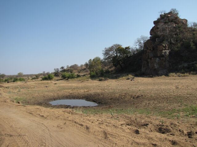
At the waypoint coordinates you will see the cliff face of a resistant Rhyolite Dyke which was uplifted to the surface by volcanic eruptions. It is fine-grained to glassy and has a high silica content. On either side of the resistant Rhyolite Dyke one can observe the Basalt flow, which has a lower silica content and contains abundant dark minerals, plus feldspar. Both types of rocks mentioned are igneous rocks.
The Basalt is softer and more easily weathered and is of the Letaba Formation, whereas the Rhyolite is of the more competent Rhyolitic rocks of the Jozini Formation.
Igneous rocks are formed when molten magma, generated deep within the Earth’s crust, rises to shallower levels, crystallising as it cools. Volcanic rocks erupt, from volcanoes or fissures, at the surface or underwater. They cool and crystallise fast, so are fine-grained. Those that don’t quite make it to the surface, called hypabyssal rocks, crystallise more slowly and are moderately fine-grained, while plutonic rocks, which intrude at deep levels in the crust, cool even more slowly and may be very coarse-grained. The most conspicuous examples of fine-grained intrusive rocks in South Africa are vertical – or nearly vertical – dykes. What you see in front of you is a good example of a vertical dyke.
Sources and recognition:
Geological Journeys – Nick Norman & Gavin Whitfield
The General Geology of the Kruger National Park by I.C. Schutte (1986)
Wikipedia
www.sanparks.org