PT
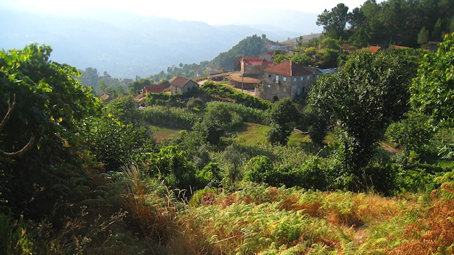
Esta é a mais difícil de um conjunto de três caches que mostram os
antigos caminhos rurais que durante centenas de anos serviram as
povoações destas regiões remotas do Douro.
EN
This is the hardest of three caches that shows the ancient rural
paths that for hundred of years served this rural comunities of the
Douro region.
 PT
PT
Dicas e Informações:
- Esta cache é a mais difícil das três. Inclui um desnivel
considerável e uma caminhada de cerca de 3Km.
- Poderá aproveitar e fazer um piquenique e refrescar as
energias.
- O ponto de partida para cada uma das três caches ficam a poucos
metros uns dos outros, por isso o automóvel poderá ficar
estacionado na berma da estrada e explorar a zona a pé.
- A primeira coordenada mostra o inicio do trilho. As coordenadas
devem ser introduzidas pela ordem dada de modo a seguir pelos
percursos correctos.
- Seguir sempre pelos caminhos rurais (não entre em propriedade
privada) e quando houver encruzilhadas seguir na direcção das
coordenadas dadas.
1º ponto (inicio do trilho):
N 41° 02.908 W
08° 02.674
Introduzir a coordenada seguinte e seguir nessa direcção.
2º ponto:
N 41° 02.933 W
08° 02.649
Subir pelo caminho junto à casa verde, observe o local onde os
cereais eram processados e guardados.
Na capela terá uma vista previligiada sobre a aldeia e o vale da
Bestança.
3º ponto:
N 41° 02.902 W
08° 02.584
Quando chegar a este ponto procure por umas escadas de pedra
contruidas no próprio muro. Verifique se consegue subir sem
problemas... Se tiver crianças pequenas ou problemas de equilibrio
não suba, siga pelo caminho alternativo e introduza as coordenadas
do 4º ponto. Se subir pelo muro, introduza as coordenadas do 5º
ponto.
4º ponto:
N 41° 02.736 W
08° 02.581
Siga para este ponto caso não consiga subir as escadas do ponto 3.
Quando chegar a estas coordenadas introduza então as coordenadas do
5º ponto.
5º ponto: Encruzilhada
N 41° 02.866 W
08° 02.462
Subir pelo antigo caminho rural de pedras e seguir sempre pelo
caminho. Irá observar campos de cultivo e gradualmente a paisagem
irá modificar-se lentamente para zonas de pinheiros e finalmente
uma paisagem de montanha.
6º ponto: Cache
N 41° 02.946 W
08° 02.151
Ponto final da cache... Aproveite as vistas e o sossego da
paisagem.
No regresso ao ponto inicial caso tenha subido pelo muro, faça
agora o percurso pelo caminho alternativo, quando chegar ao 5º
ponto introduza as coordenadas do 4º ponto.
EN
Informations and Tips:
- This is the hardest of the LostTracks series. Includes a hike of
3Km but the scnerery is unique.
- The start point for each one of this three caches are few meters
away from one another, so you can leave your automobile in the road
and visit all of them.
- This first coordinate shows the beginning of the trail. The
coordinates should be introduced by the given order so you follow
the correct path.
- Always walk in the rural paths (don't enter privat property) and
in the crosspaths follow the given coordinates.
1st stage (trail start):
N 41° 02.908 W
08° 02.674
Introduce the following coordinate and follow that direction.
2nd stage:
N 41° 02.933 W
08° 02.649
Go up the path next the green house. Watch were the cereals were
processed and stored.
In the chappel you'll have a great view over the village and the
Bestança valley.
3rd stage:
N 41° 02.902 W
08° 02.584
When you get to this point search for a stairs made of stone built
in the wall itself. Check if you can climb those stair without any
problem. If you are with children or have balance issues use the
alternative path, just introduce the coordinates of the 4th stage.
If you can climb the wall, introduce the coordinates of the 5th
stage.
4th stage:
N 41° 02.736 W
08° 02.581
Go to this stage if you can't climb the stairs of the 3rd
stage.
When you get to these coordinates introduce the coordinates of the
5th stage.
5th stage:
N 41° 02.866 W
08° 02.462
Go up through the ancient rural path made of stones e follow always
that trail. You'll see crop fields, pine e finally a mountain
scenery.
6th stage: Cache
N 41° 02.946 W
08° 02.151
Enjoy the viewes and the sounds of nature.
In the way back if you climbed the wall you can return using the
alternative path. When you get to 5th stage coordinates just
introduce the coordinates for the 4th stage.
Aãb rfgá ab zheb, rfgá qronvkb qr hzn crqen qrageb qb pnzcb, greá qr fnygne b zheb r cebphene ab puãb.
Vg'f ABG va gur jnyy ohg haqrearngu n fgbar vafvqr gur svryq. Lbh'yy unir gb whzc gur jnyy naq frnepu va gur tebhaq.