Tidal Forces-Hole in the Wall EarthCache
Tidal Forces-Hole in the Wall
-
Difficulty:
-

-
Terrain:
-
Size:  (not chosen)
Related Web Page
Please note Use of geocaching.com services is subject to the terms and conditions
in our disclaimer.
Definitions:
Tidal Force
Any of various gravitational forces acting on an extended body as a result of the varying distance between the source of the gravitational force and the different parts of the extended body closest to and farthest from the force.
Tide
The periodic variation in the surface level of the oceans and of bays, gulfs, inlets, and estuaries, caused by gravitational attraction of the moon and sun.
The tide rises, the tide falls, The twilight darkens, the curlew calls; Along the sea-sands damp and brown The traveler hastens toward the town, And the tide rises, the tide falls.
Darkness settles on roofs and walls, But the sea, the sea in darkness calls; The little waves, with their soft, white hands Efface the footprints in the sands, And the tide rises, the tide falls.
The morning breaks; the steeds in their stalls Stamp and neigh, as the hostler calls; The day returns, but nevermore Returns the traveler to the shore. And the tide rises, the tide falls.
-Henry Wadsworth Longfellow
As defined above, the most visible tidal force on earth is the affect of the moon, and to a lesser extent the sun, on the earth's oceans. These tidal forces manifest themselves in the observable occurance of tides, the rising and falling of the earth's oceans.
Tidal Forces also have an effect on the Earth’s constituents other than it’s oceans. Small tides can occur on large lakes such as the Great Lakes, on the Earths crust and even on its atmosphere. Forces exerted on Earths crust, known as earth tides, have been shown in some cases to trigger earthquakes.
As previously stated the most observable tidal phenomenon on Earth is on its oceans, the daily rising and falling of Sea Levels known as tides. Tides occur in stages. The following is an excerpt from Wikipedia on how these stages occur:
- Sea level rises over several hours, covering the intertidal zone; flood tide.
- The water rises to its highest level, reaching high tide.
- Sea level falls over several hours, revealing the intertidal zone; ebb tide.
- The water stops falling, reaching low tide.
...And the tide rises, the tide falls
The continual ebb and flood of the tides create currents that have a profound affect on the geology, geography, and ecology of our Earth’s beaches and sea shores. The constant pounding of the waves combined with the wind and rain causes erosion of both the sandy beaches and the hard rock underneath. This erosion can be seen in many forms including the formation of tide pools. Tide Pools are often separate entities from the ocean itself occurring in indentations in rocky outcroppings or in rocks found on beaches in the intertidal region, the area continually exposed and flooded by the ebb and flow of the Tides.
...And the tide rises, the tide falls
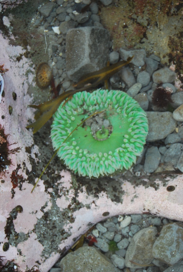
Tide pools provide a home for hardy organisms such as anenomes, sea stars, mussels and clams, barnacles and several forms of kelp and seaweed are also found in the intertidal region. Inhabitants must be able to cope with a constantly changing environment — fluctuations in water temperature, salinity, and oxygen content. Huge waves, strong currents, exposure to midday sun and predators are only a few of the hazards that tide pools' animals must endure to survive. The same can be said to varying degrees to organisms inhabiting the other areas of the intertidal region.
...And the tide rises, the tide falls |
 |
 |
The intertidal region is divided into distinct zones, (low, middle, and high), based on the overall average exposure of the zone. The low intertidal zone, is only exposed to air at the lowest of low tides and is primarily marine in character. The mid intertidal zone is regularly exposed and submerged by average tides. The high intertidal zone is only covered by the highest of the high tides, and spends much of its time as terrestrial habitat. The high intertidal zone borders on the splash zone (the region above the highest still-tide level, but which receives wave splash). On shores exposed to heavy wave action, the intertidal zone will be influenced by waves, as the spray from breaking waves will extend the intertidal zone. ...And the tide rises, the tide falls
|
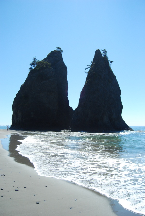
| In the Olympic National Park along the Washington Coast, tides have had a large affect on the areas geography. Vast sand beaches contrasted sharply by huge rock formations continually pounded by the wind and waves and amplified by the tides have created a wild geography that is stunningly beautiful. The large rock formations are known as sea stacks. |
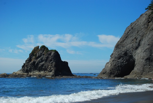 |
The coordinates I have supplied you with will bring you to a place that is in close proximity to two different sets of Sea Stacks as well within view of several others that are further out in the ocean. ...And the tide rises, the tide falls
The following picture is a link to a NASA video of how the sun and the moon work together to affect the earth's oceans. The sun, being farther from the earth exerts a smaller force than that of the moon, which although much smaller than the sun, it's closer proximity has a greater affect. ...And the tide rises, the tide falls
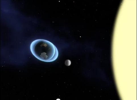 The video shows how as the moon orbits the earth it pulls on the earth's oceans while the sun exerts a similar although longer term and smaller force as the earth orbits the sun. The greatest effect is when the sun, earth and moon are all in alignment, either with the moon directly between the earth and the sun or the earth directly between the moon and the sun. The greatest differences in the high and low tides occur during the full and new moons that happen in the spring and the fall when the earths elliptical orbit brings it to it's closest proximity to the sun.
...And the tide rises, the tide falls
While attempting to complete the requirements of this cache, please observe all of the rules posted by the National Park Service. The easiest way to get to the cache is to drive to the posted parking coordinates at Rialto Beach. Please note that dogs are not allowed down the beach as far as hole in the wall but leashed dogs are allowed to a point a half mile from the Parking Lot at Rialto Beach.
The hike to Hole in the Wall is just over a mile north of the parking along hard packed sand beach. Plenty of beach is exposed to get to the cache site, even during high tide but please be aware of the tides if you plan to venture further North along the coast past Hole in the Wall. Be sure to check the local tides before a hike along any of the wild beaches in Olympic National Park. There is an overland trail that is available to get to the other side of the wall during high tide but could be a difficult climb to some individuals. A back country pass is required to camp along the beach. Passes are available at the Mora Ranger Station on Mora Rd. (WA-SR 110) prior to reaching Rialto Beach. No pass is required for those not staying overnight.
To claim a find, send your answers and write your log at the same time. EVERY CACHER LOGGING A FIND MUST SEND ANSWERS AT THE SAME TIME AS THE FOUND LOG. No group answers. No exceptions. If I delete your log, it will be due to a failure to follow this instruction. You can then send the answers and re-post your find at the same time.
To log this cache please provide the following information in your online log on the cache page:
1) Provide the date and time of your visit to the site and state whether it was during a high or low tide. State whether you were able to pass through Hole in the Wall or if the water level made it impassable.
2) Describe the exposure level of the intertidal region during your visit. Which zones of the intertidal region were exposed? Report on any sea life in each of the zones you were able to observe. Optionally, you may post photos of the sea life you observe in the different intertidal zones.
3) Finally and to prove that you actually visited the site you must e-mail me the following information:
At the posted coords, a few hundred feet away from the hole is a tree. There is something attached to the tree. Describe in your e-mail what it is and what it's purpose is. Explain how this item relates to the subject of this earth cache. Be specific about it's physical charcteristics, height off the ground, size, shape, color, etc. Do not include any photos or descriptions of the tree and what is attached to it in your online log or it will be deleted without notification. You will be able to re-post your log without including the photo at any time after that provided that I have received the required e-mail describing the tree.
(Optional, not a requirement to log the cache) Post a photo of yourself that shows you either inside of Hole in the Wall or with it in the background. This will be an acceptable option in lieu of the e-mail requirement for logging the cache.
I hope that you have enjoyed learning about tides, the Washington Coast at this location and your hike down Rialto Beach to Hole in the Wall. Thanks for taking the time and making the effort to log this Earth Cache.
Congratulations to The4LollyGaggers for being FTL!
Additional Hints
(No hints available.)