Vattenfallet finns
på privat mark, det är förbjudet att utan tillstånd ta sig enda
fram till fallet. Det går utmärkt att se från utsidan av
grinden/staketet.
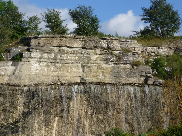
Här på en helt osannolik plats finns nog Gotlands vackraste
vattenfall! Vattnet rinner ut rakt genom den gotländska
kalkstenen.
Den del av Gotlands berggrund som befinner sig ovanför havsytan
består av sedimentära bergarter som stammar från silurperioden.
Borrningar visar att de siluriska bergarterna vilar på ett underlag
av bergarter från ordovicium och kambrium. Under silurisk tid
orsakade kontinentaldriften att Sverige närmade sig ekvatorn från
söder. De sediment som avsattes i havet var i regel kalkhaltiga och
bildar idag Gotlands kalkstenar och märgelstenar. Till kalkstenarna
räknas flera generationer av rev, som bildades nära en strand
belägen i norr eller nordväst.
Den hårdare kalkstenen återfinns i de översta lagren av Gotlands
berggrund och den vilar på den mjukare och leriga märgelstenen.
Här kan man tydligt se hur vatten som trängt ner genom sprickor
i det hårda kalklagret löst upp och eroderat det mjukare underlaget
av märgelsten. Vilket gör att nu rinner vattnet obehindrat fram
under kalkstenen.
För att få logga denna
earthcache som funnen måste du :
1. Maila svaret på de
följande fyra frågorna till cacheägaren.
A. Hur brett uppskattar du
att fallet är i meter
B. Hur högt uppskattar du
att fallet är i meter?
C. Hur har den Gotländska
siluriska kalkstenen bildats?
D. Vad är
märgelsten?
Och
2. Ladda gärna upp ett foto( i din logg) på dig vid grinden med
fallet i bakgrunden. Detta är inte ett krav men mycket
önskvärt.
[English]
When I saw this place I
immediately thought of a cache on Iceland: Hraunfossar - water from the
lava.
Here at a most unlikely place, there is probably Gotland's most
beautiful waterfall! Water drains right through the
limestone.
The part ofGotland bedrock that is above
sea level consists of sedimentary rocks, which stems from the
Silurian period. Drilling indicates that the Silurian rocks rest on
a foundation of rocks from the Ordovician and Cambrian. During the
Silurian period the continental drift was Sweden approaching the
equator from the south. The sediments deposited in the sea were
generally calcareous, forming todays Gotland limestone and
marlstone. For limestone counted several generations of the reef,
which formed near a beach located in the north or
northwest.
The harder limestone found
in the uppermost layers of the bedrock of Gotland and the rest on
the soft and muddy marlstone.
Here you can clearly see how the water that seeped down through
cracks in the hard limestone layer dissolved and eroded the softer
surface of the marl. Which means that now the water flows freely
out under the limestone?
In order to log this cache as found earth, you must:
1st Mail the answer of the following questions to the cache
owner.
A. How large do you estimate that the waterfall is in meters
B. How high do you estimate that the waterfall is in meters?
C. How has the Gotland Silurian limestone formed?
D. What is marlstone?
and
2nd Feel free to upload a photo (in your log) of you at the gate
with the waterfall in the background. This is not a requirement but
highly desirable.
 Free counters