A ilha do Corvo é a mais pequena dos Açores (com apenas 17 km2) e, com a ilha das Flores, integra o Grupo Ocidental do arquipélago. Está implantada na placa tectónica Norte Americana, a cerca de 110 km para Oeste do Rift Médio Atlântico.
.
Toda a ilha corresponde a um edifício vulcânico poligenético, com uma caldeira no seu topo (o Caldeirão) e cerca de uma vintena de cones secundários nos seus flancos e intra-caldeira. Trata-se, assim, de uma “ilha vulcão”, a única do arquipélago com estas características.
Edificada sobre fundo oceânico com cerca de 10 milhões de anos. As ilhas das Flores e do Corvo emergem do mesmo banco submarino, de orientação NNE-SSO. A sua tectónica é controlada por falhas orientadas aproximadamente Norte-Sul, paralelas à Crista Média Atlântica e por falhas transformantes com direcção Oeste-Este, que segmentam o vale do rift.
A ilha corresponde a um vulcão do tipo central, que começou a emergir há cerca de 730 mil anos. O colapso da cratera terá ocorrido há 430 mil anos. Antes da formação da cratera, estima-se que o cone central teria cerca de 1 000 metros de altitude.
Apesar da sua reduzida dimensão, a ilha do Corvo apresenta uma assinalável diversidade de rochas e estruturas geológicas e vulcânicas, incluindo basaltos, traquitos, pedra pomes, escórias (ou bagacina) e lahars, falhas geológicas, depósitos sedimentares actuais, cordões litorais e inúmeros filões.
Estes últimos, de tamanho, forma e orientação variadas, são especialmente visíveis nas falésias costeiras Norte e Oeste da ilha do Corvo.
O Caldeirão é o principal elemento vulcânico e paisagístico da ilha.
Esta caldeira, com um diâmetro máximo de 2,3 km e profundidade de 320 metros, possui uma lagoa e no seu interior estão implantados 12 cones secundários, na sua maioria cones de escórias.
Dada a erosão marinha a que está sujeito, a natureza dos seus produtos vulcânicos e ao facto desta ilha não possuir vulcanismo histórico nem qualquer actividade vulcânica recente (isto é, nos últimos milhares de anos), o litoral da ilha do Corvo apresenta-se muito escarpado e alto, com excepção da fajã lávica de Vila Nova do Corvo, onde ocorreu a última erupção vulcânica na ilha.
Aliado à erosão marinha, a ilha enfrenta erosão provocada pelos ventos dominantes de nordeste e oeste. As vertentes do vulcão encontram-se parcialmente preservadas nos flancos Sul e Leste (com altitudes entre 150 a 250 metros), muito reduzidas pelo recuo das arribas litorais a norte e completamente ausentes a oeste (com altitudes entre 500 a 700 metros). O recuo das arribas já alcançou o bordo oeste da caldeira. Na vertente sul, sobressaem cones secundários – Coroínha, Morro da Fonte, Grotão da Castelhana e Coroa do Pico – que se encontram bem preservados da acção erosiva, responsáveis pelo derrames basálticos que formaram a fajã lávica (com altitudes entre 10 a 60 metros).
A extremidade noroeste da ilha constitui a Ponta Torrais, saliente e notável, em espinhaço aguçado e com cristas pontiagudas, tendo na sua face norte um pequeno ilhéu cónico, o ilhéu dos Torrais. Na costa norte e noroeste existe outro pequeno ilhéu, o Ilhéu do Torrão, e alguns recifes submersos perigosos para a navegação.
Sobre a EarthCache
Responda às questões:
a) Qual a profundidade máxima do Caldeirão?
b) Qual era a altura estimada do vulcão antes do seu colapso?
c) Indique dois tipos de rochas presentes nesta caldeira de vulcão.
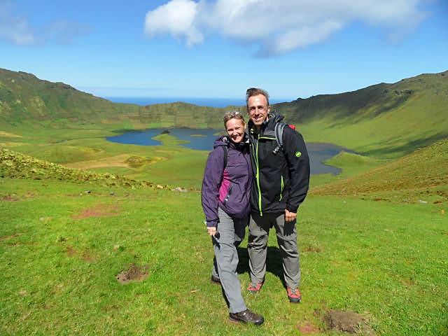
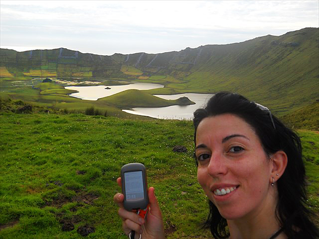
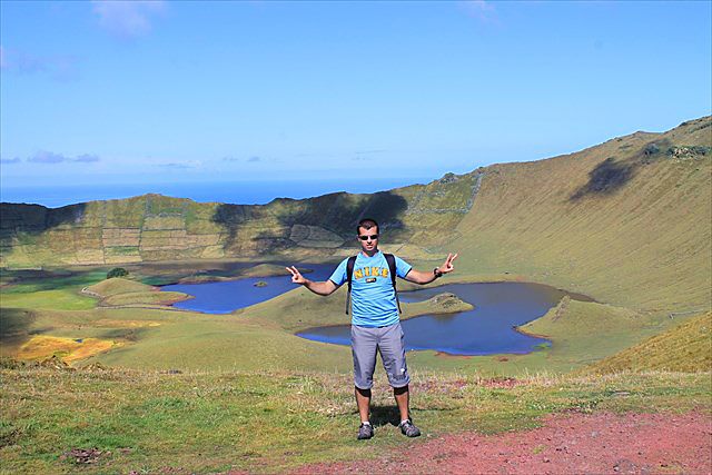
Também e apesar de ser opcional, por favor, tire uma foto de si mesmo com o seu GPS em frente ao Caldeirão e mostre-a juntamente com o seu log.
Envie as respostas através do meu perfil geocaching e desfrute da sua visita.
Envie por correio electrónico as respostas e a imagem para netuseraz (at) hotmail (dot) com antes de efectuar o log do cache. Eu darei feedback a autorizar.
The island of Corvo is the smallest of the Azores (with only 17 km2) and with the island of Flores, completes the Western Group of the archipelago. Is implemented in the North American tectonic plate, about 110 km west of the Mid-Atlantic Rift.
The entire island corresponds to a polygenetic volcanic edifice, with a boiler at the top (the Cauldron - Caldeirão) and about a score of cones on their side flanks and intra-boiler. It is thus a "volcano island", the unique one in the archipelago with these characteristics.
Built on the ocean floor about 10 million years. The islands of Flores and Corvo emerge from the same submarine bank orientation NNE-SSW. Its is controlled by tectonic faults oriented roughly north-south, parallel to the Mid-Atlantic Ridge, and by transform faults with west-east direction, that segmented the rift valley.
The island corresponds to a central type volcano, which began to emerge for about 730,000 years. The collapse of the crater have occurred 430,000 years ago. Before the formation of the crater, it is estimated that the central cone would be about 1000 meters of altitude.
Despite its small size, the island of Corvo has a remarkable diversity of rocks and volcanic and geological structures, including basalts, trachytes, pumice, slag and lahars, faults, sedimentary deposits present, coastal ridges and numerous veins . The last ones are especially visible in the coastal cliffs north and west of the island of Corvo.
The Cauldron (Caldeirão) is the main element and volcanic landscape of the island. This boiler, with a maximum diameter of 2.3 km and a depth of 320 meters, has a pond and within 12 cones are deployed side, mostly cones of slag.
Due to the sea erosion that is subject, the nature of its volcanic products and the fact that this island does not have any historical volcanism or recent volcanic activity (ie, in the last thousand years), the coast of Corvo appears very steep and high, with the exception of lava landform of Vila Nova do Corvo, where the last volcanic eruption occurred on the island.
Allied to marine erosion, the island faces erosion by prevailing winds from the northeast and west. The slopes of the volcano are partly preserved in the south and east flanks (with altitudes between 150 and 250 meters), greatly reduced by the retreat of coastal cliffs to the north and west completely absent (with altitudes between 500 and 700 meters). The retreat of the cliffs has already reached the western edge of the boiler. On the southern slope, stand side which are well preserved from the erosive action, responsible for basaltic lava that formed the landforms (with altitudes between 10 and 60 meters).
The northwest end of the island is the Ponta Torrais, prominent and remarkable, ridged with sharp and jagged ridges, and in its north face of a small conical islet, the islet of Torras. On the north and northwest coast there is another small island, the islet of the Torrão, and some submerged reefs dangerous to navigation.
About the EarthCache
Answer these tasks:
a) Estimate what is the maximum depth of the boiler (Caldeirão)? (hint: use your gps to measure)
b) What was the estimated height of the volcano before is collapse?
c) Name two kinds of rocks that are present in this volcano boiler.
Being OPTIONAL, please also log an image with yourself on the spot making the cache with the GPS.
Send me the answers via my geocaching profile and enjoy your visit
E-mail me the answer and the image to netuseraz (at) hotmail (dot) com before logging the cache.
I will get back to you with the permission to do so.