Loon Lake Formation
EC
There is a $5 day use
fee associated with this EC.
Loon Lake is a
294-acre lake located in Douglas County in the Oregon Coast
Range of the United States, approximately 15 miles (24 km)
east-southeast of Reedsport, Oregon. The lake is about two
miles (3 km) long with a maximum width of about 0.4 mile (0.6 km),
and is about 150 feet deep in some places. The lake is "a classic
example of a landslide lake.” The lake was discovered in 1852
and named for the loons found on its waters. Few loons are
seen here now.

About 1,400 years ago a major landslide
in the coast range of western Oregon sent a mountainside of debris
and house-size sandstone boulders down into and across a deep and
narrow river canyon. The resulting dam combined with the annual
rainfall formed Loon Lake. At its outlet, Mill Creek drops over 120
feet in less than 1/4 mile of spectacular waterfalls and pools.
The first inhabitants were Indians who
traveled on foot from the coast and from inland valleys. They came
mostly to Ash Valley to camp, gather huckleberries and hunt elk. In
the year 1850, when Scottsburg was becoming an important commercial
trade center, two men were following Indian trails when they
discovered the lake and named it after the common Loon duck which
they had seen nesting. Early settlers lived in Ash Valley where
they farmed, trapped, hunted and traded for a living. Not until the
1930's did Loon Lake receive significant attention when it was used
for storing logs for transporting them by truck to the mill in
Gardiner on the coast of Oregon. The logging road into the north
end of the lake provided the first access by automobile. By the
early 1960's the site where logs had been loaded onto trucks became
a popular recreation area for the whole family.
Oregon contains over 6,000 lakes and
reservoirs with a combined surface area of over 500,000 acres that
are a vital water resource for the state. Reservoirs provide
hydropower, irrigation, recreation, drinking water, and flood
control uses. Natural lakes provide similar benefits and are also
important habitat for many species of fish, birds, amphibians,
invertebrates and native plant communities.
Landslides and river activity are also common
methods of natural lake formation. Triangle Lake, west of Eugene,
and Loon Lake, east of Reedsport are examples of landslide-formed
lakes.
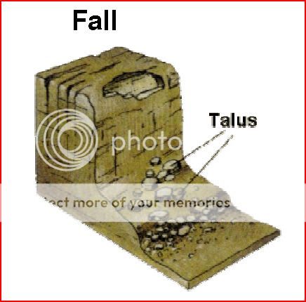
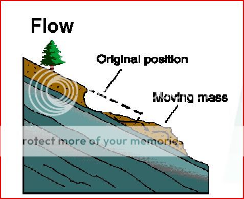
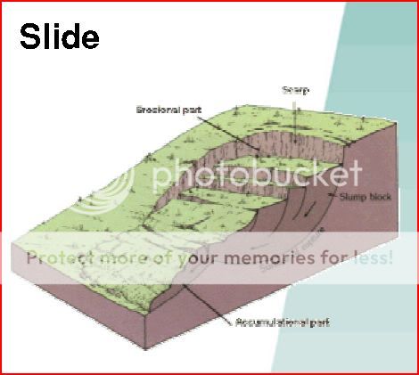
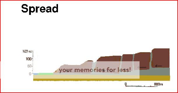
Landslide dams form in a wide range of
physiographic settings.The most common types of mass movements that
form landslidedams are rock and debris avalanches; rock and soil
slumps andslides; and mud, debris, and earth flows. The most common
initiationmechanisms for dam-forming landslides are excessive
rainfalland snowmelt and earthquakes.
Landslide dams can be classified into six
categories based ontheir relation with the valley floor.
Type I dams (11% of 184landslide dams from around
the world that we were able to classify)do not reach from one
valley side to the other. Type II dams(44%) span
the entire valley floor, in some cases depositingmaterial high on
opposite valley sides. Type III dams (41%)move
considerable distances both upstream and downstream fromthe
landslide failure. Type IV dams (<1%) are rare
and involvethe contemporaneous failure of material from both sides
of avalley. Type V dams (<1%) also are rare and
are created whena single landslide sends multiple tongues of debris
into a valleyand forms two or more landslide dams in the same reach
of river.Type VI dams (3%) involve one or more
failure surfaces thatextend under the stream or valley and emerge
on the oppositevalley side.
Many landslide dams fail shortly after
formation. In our sampleof 73 documented landslide-dam failures,
27% of the landslidedams failed less than 1 day after formation,
and about 50% failedwithin 10 days. Over-topping is by far the most
common causeof failure.
The way lakes are formed has important
consequences for the subsequent physical, chemical, and biological
characteristics of lakes. The process responsible for lake
formation is largely responsible for the shape and depth of a lake.
Oxbow lakes, for example are relatively shallow, long, and narrow.
Reservoirs and landslide lakes have long shorelines relative to the
lake volume because of their dendritic shape. Basin shape in turn,
determines the temperature of the water, degree of stratification,
and the dissolved gas content of the lake. All these features have
consequences for the organisms that live in the lake or
reservoir.
The chemical composition of lake water is
determined by the climate and geology of the watershed of a lake.
Rainfall in the watershed carries sediment and dissolved rock
minerals into a lake. The amount of rainfall, summer evaporation,
and flow through a lake can alter the lake chemistry.
The diverse climate and geology of Oregon,
combined with the multiple methods of basin formation in the State,
results in an incredible range of lake types. The range of lake
depth in Oregon exceeds that of any other place in North America.
The geologic and climate differences between the coast, the high
Cascades, and the basin and range region in eastern Oregon also
contribute to the diversity of lake types. Chemistry of Oregon
lakes ranges from the nearly distilled water (no dissolved salts)
in Waldo Lake to the hypersalinity (greater than ocean salinity) of
Abert Lake.
Although there are many lakes along the Oregon
Coast, there are very few in the Coast Range. High precipitation
over the last two million years, combined with tectonic uplift of
the mountains, produced steep-walled, narrow valleys throughout the
range. The glacial and volcanic processes that were responsible for
most of the Cascade Mountain lakes were virtually non-existent in
the Coast Range. However, landslides in the rugged topography are
quite common, and the few natural lakes that do exist were formed
where massive slides blocked a river valley, impounding water
behind it. The only two large natural lakes in the Coast Range,
Triangle Lake and Loon Lake, were formed in this manner.
Loon Lake was formed when the stream flowing
through this valley was blocked by a mass of sandstone that
evidently came from high on the west slope of the valley. The creek
found its outlet against the north wall where it cut through the
slide material. The life of the lake is limited by two factors;
alluvial deposits and sedimentation in the upper end of the lake
and erosion of the outlet.
- What is the elevation at the GZ?
- At WP 1 there is a boulder that fell as part of the landslide
creating the lake. Estimate its length.
- Based on the text and your observations, what category
landslide dam created Loon Lake?
- Why has this landslide dam on Mill Creek lasted so long? (1400
yrs)