 For 100 years, the National Park Service has preserved America’s special places “for the enjoyment, education, and inspiration of this and future generations.” Celebrate its second century with the Find Your Park GeoTour that launched April 2016 and explore these geocaches placed for you by National Park Service Rangers and their partners.
geocaching.com/play/geotours/findyourpark
To claim credit for this EarthCache it is required that you send me an email with your answers to the questions below. The Posted Coordinates take you to the Park Building Entrance (great photo opportunity by the sign). The Compass Rose is about 80 feet east of the Posted Coordinates (waypoint provided below). A Trailhead waypoint is included below for the start of the Boardwalk. At this location you can view mangrove trees in their natural setting as well as erosion control (rip-rap) boulders. Taking the boardwalk and trail out to the very end will also allow you to view, to the East, the island of Elliott Key. Inside the Visitor Centre is a large walk-through display that provides a great visual depiction of the geology and ecology of the Biscayne Bay.
Biscayne National Park Area Map
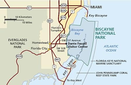
Biscayne National Park was designated a National Park in 1968 and later enlarged to about 172,925 total acres, of which 168,552 acres are marine. As the largest marine park in the National Park System, Biscayne National Park consists of four primary ecosystems:
1. A narrow fringe of mangrove forest along the mainland shoreline.
2. The southern expanse of Biscayne Bay.
3. The northernmost islands of the Florida Keys.
4. The beginning of the third-largest coral reef in the world.
Each of these ecosystems is comprised of a variety of smaller communities like seagrass meadows, hardbottom areas, and hardwood hammocks. The geology of the area has been influenced by changing sea levels, currents, hurricanes, and reef-building organisms like corals.
Biscayne's Mangrove Forest
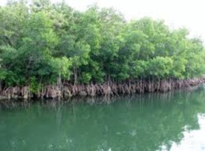
Mangrove trees can grow in the unstable and salty soil that is flooded by the sea when the tide comes in twice in a day. Their trunk and even the canopy may be covered by tidal water during high tide periods. The mangroves also face the risk of being washed away by tides due to the unstable substrate. To anchor themselves firmly in the soil some mangrove trees develop prop roots which are long roots that grow down from the trunks and branches of the trees and get anchored in the mud. These stilt-like roots trap leaves, detritus, and other floating debris making the trees’ footing firmer.
Mangroves play an indispensable role in the protection of the coasts and in maintaining the bio-diversity of the Bay. Mangrove trees and their complex root systems slow down the tidal waters and help dissipate the tidal energy. They also slow down stormwater runoff from the land and act as storm breakers during bad weather. Therefore, mangroves play a very important role in minimizing the process of erosion of soils or sediments. The rainwater that flows from land to sea contains fine mud called silt, as well as leaves and other organic materials. Mangroves trap these materials and they are used as nutrients by plants and animals. Mangroves also help to create more land area by slowly inching their way towards the sea, colonizing a tiny bit of sea each year.
Biscayne Bay (southern expanse)
Biscayne Bay is a shallow estuary where freshwater runoff from the land mixes with saltwater from the sea. Beneath the Bay's clear, shallow waters are two primary ecosystems: hardbottom and seagrass.
Hardbottom
In areas where the sand and sediments are thin (less than a few inches), plants like seagrasses cannot take root. These areas are appropriately called hardbottom, and could be described as an underwater desert. Although the hardbottom areas may appear barren and lifeless, they are home to soft corals, sponges, and numerous other invertebrates that find shelter inside the sponges or beneath the sediments. The central Biscayne Bay area between the mainland and Elliott Key is an area dominated by hardbottom communities.
Seagrass Meadows

Where bottom sediments are more than just a few inches thick, as they are in the East area of Biscayne Bay, lush meadows of seagrasses form. Like the grasses of your lawn at home, seagrasses are flowering plants. They have roots, stems, and flowers. They produce oxygen. And without exceptionally clear water that allows the sunlight to reach them, seagrasses will die just as your lawn at home would if it were deprived of sunlight.
Northernmost Florida Keys
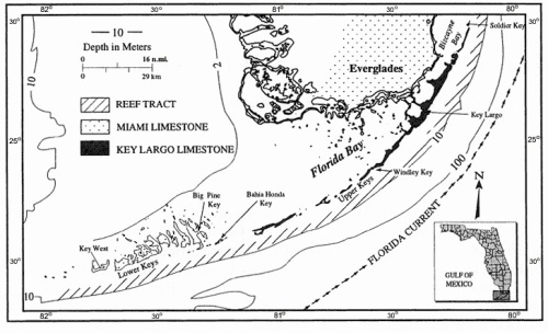
Elliott Key, just south of Soldier Key, is the park's largest island, and is considered the first of the true Florida Keys. It, and the keys to its south, are the remains of fossilized coral reefs (Key Largo Limestone) which formed when ocean waters were much higher than they are now. Walking the island today, you can see the remains of the coral, even identifying the types of coral that you are treading on. The islands to the north of Elliott Key, from Soldier Key north to Sands Key, are considered "transitional" islands – sharing some of the features of the hard rock coral keys to the south and some with the sand barrier islands to the north. Together, these islands provide a protective barrier between the ocean to the east, and the shallow waters of Biscayne Bay to the west. They provide a place for relaxation, contemplation, and exploration as well as a stepping stone to the living coral reefs to the east.
Together they anchor the northern end of the coral rock Florida Keys and transition to the sand barrier islands of the north. To the south of Elliott Key through Key Largo to Big Pine Key, are the Keys that are made up of the ancient Key Largo Limestone, followed by the Lower Keys which are comprised of the Miami Oolitic Limestone.
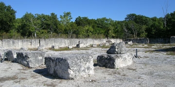
At Windley Key (see photo above), near Islamorada, the fossilized Key Largo Limestone is easily explored and viewed at the Windley Key Fossil Reef Geological State Park, at U.S. 1 Mile Marker 84.9 Islamorada.
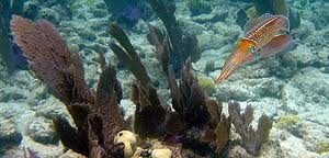
Coral Reefs of the Florida Keys
Florida's living coral reefs came into existence 5,000 to 7,000 years ago when sea levels rose following the Wisconsin Ice Age. Reef growth is slow; estimates range from one to sixteen feet every 1,000 years.
Hard Coral
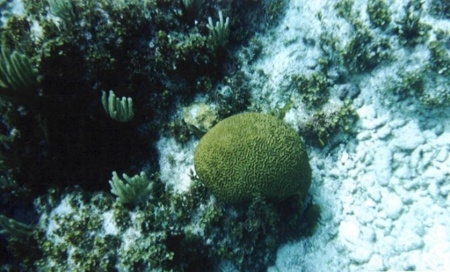
Hard corals, also known as scleractinian and stony coral, produce a rigid skeleton made of calcium carbonate (CaCO3) in crystal form called aragonite. Hard corals are the primary reef-building corals. Colonial hard corals consist of hundreds to hundreds of thousands of individual polyps. Hard corals that form reefs are called hermatypic coral. Hermatypic coral polyps secrete calcium carbonate from their base, forming the calyx. Periodically, the polyp will lift off its basal plate and secrete a new one, creating a tiny chamber in the coral skeleton. All the polyps in a colony deposit calcium carbonate and add chambers to the skeleton, growing upwards. When the polyp dies, if the colony is still living, a new polyp will grow on top of the skeleton of the dead polyp. The living polyps form a thin layer of tissue over the skeletons of dead polyps. Over time, this growth forms the primary structure of a coral reef.
Other stony coral species are incapable of producing sufficient quantities of calcium carbonate to form reefs. Many of these corals do not rely on the algal metabolites produced by zooxanthellae, and live in deeper and/or colder waters beyond the geographic range of most reef systems. Some of these deep-sea stony corals may form community structures that resemble forests, but do not build reefs. Other stony deep-sea corals, Oculina and Lophelia species, for example, do build reefs.
The rate at which a stony coral colony lays down calcium carbonate depends on the species, but some of the branching species can increase in height or length by as much as 10 cm a year (about the same rate at which human hair grows). Other corals, like the dome and plate species are more bulky and may only grow 0.3 to 2 cm per year.
Coral reefs are the largest biological structure on earth; some of them can even be seen from space.
Making Limestone (a typical process)
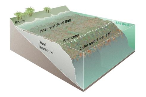
Over time, coral reefs accumulate on the seabed and become buried by other sediments. As more and more sediment is deposited on top, the weight of that sediment compacts the reef material. In addition, the original calcium carbonate from marine organisms (coral polyps) acts as a cement between sedimentary particles. The result of compaction and cementation converts reef sediments into the rock called limestone.
When sea level is stationary, reefs will grow laterally in a seaward direction as reef sediments accumulate. Over long periods of time reef sediments will accumulate and the growing pile will build up in a seaward direction. Over time, this reef material will build broad shoals and platforms just below and near the ocean's surface. However, if sea level rises and reefs are submerged by deep water, they will die. The deep water isolates them from the necessary solar light and warm water conditions they require. Similarly, a drop in sea level could leave them exposed on land.
Completing this Earthcache:
Photos (optional): You may include with your log, a photo of you and your party, or just your GPSr, in front of the wall with the large green metal fish mounted on it. The wall is 15-20 feet south of the provided compass rose coordinates. Or, you may simply include in your EMail to us the coordinates inscribed on the Compass Rose?
To get credit for completing this Earthcache, please submit to us through our Profile an EMail with your answers to the following questions:
1. At the provided Trailhead waypoint you will be able to view the bay. Which type of bottom do you think is present here. Hardbottom with thin sediments, or Seagrass Meadows with thick bottom sediments?
2. Mangrove trees play a very important role in minimizing a damaging process that can change the geology (soils or sediments) in the area. What process is this?
3. Do seagrasses grow in hardbottom areas with soft corals and sponges?
4. Which type of Limestone are Elliott Key and the northern Florida Keys made up of?
5. Hermatypic Coral polyps secrete a substance which acts as a cement between sedimentary particles. Then over time, the compaction and cementation converts reef sediments into the rock called limestone. What is the name of that substance?
| MulderNScully has earned GSA's highest level: |
 |
FTF - Auyanteupy
Congrats to soflfamily on #2,200