BODACH AN STÒR (ISLE OF SKYE) EarthCache
BODACH AN STÒR (ISLE OF SKYE)
-
Difficulty:
-

-
Terrain:
-

Size:  (other)
Please note Use of geocaching.com services is subject to the terms and conditions
in our disclaimer.
BODACH AN STOR = THE OLD MAN OF STORR
To let this earthcache family- and kids-friendly we plan this cache as an almost drive-in cache. It is not necessary to do the 7 kms walk to get credit for this cache.
But you have to stop at two different places to fulfil the tasks!
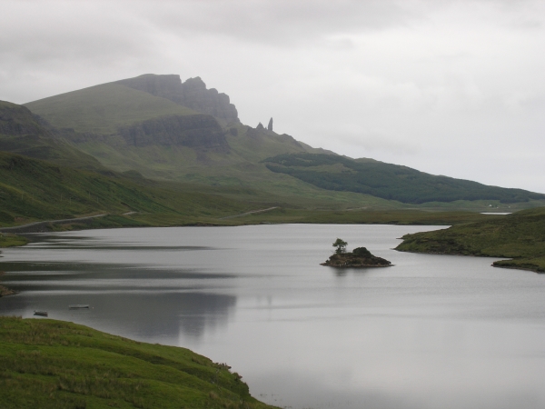
The Storr (a norseman word for high steep pinnacle) including the Old Man of Storr are part of the peninsula Trotternish on Skye.
The Storr is the highest point on the Trotternish Ridge (highest point 719 meters) and the Trotternish Ridge is Britain's longest and most spectacular landslip. The Storr mountain is a 300 meters thick sandwich of around 24 layers of volcanic rocks formed between 61 and 55 million years ago. It consists of huge volcanic buttresses and basalt cliffs that drop towards the sea, creating a landscape of beautiful und unique rock pinnacles. The 'Old Man of Storr' is the real symbol of Trotternish, and it is visible for 15 miles south and from the north. But there are more pinnacles around, such as the Sanctuary and not far away the pinnacles of the Quiraing.
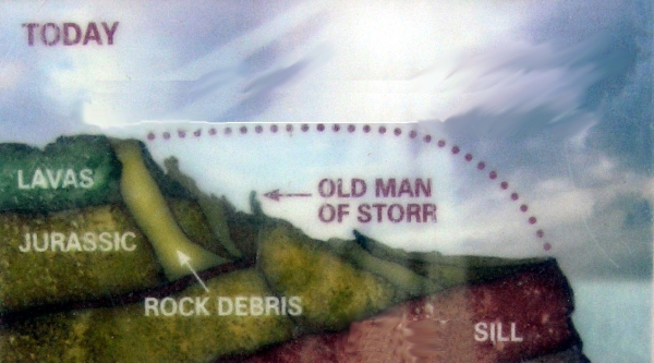
63-53 million years ago (paleoscene to early eocene epochs (both early Tertiary)) there was volcanic activity on Skye (clearly seen at the Cuillins today)
Those Tertiary lava flows on the Isle of Skye were generally only a few meters thick, and attain a maximum of around 35 meters. However, the overall thickness of the flows is great. They are the weathered remnants of what once covered a much wider area.
The geomorphology of Trotternish is the result of erosion (past and present), on these Tertiary volcanic lavas and also, in some cases, on the underlying Jurassic sediments. These lava flows caused a landslip, falling away from the weaker Jurassic sediments beneath.
The Old Man of Storr is about 48m high and is believed to be the remains of an ancient volcanic plug of the Tertiary period. The old man of Storr consists of magma derived gabbro.
Gabbro is the name for a large group of dark, coarse-grained, intrusive mafic igneous rocks chemically equivalent to basalt. The rocks are plutonic, that means it was formed when molten magma was trapped beneath the Earth's surface and cooled into a crystalline mass.
The countless rocks in this locality (like the ild man) were subjected to a combination of landslipage and subsequent erosion which occurred in the post Ice Age. The Old Man has been left standing because of the more durable composition of its geology - in relation to its surroundings which were more susceptible to erosion. So its age is about 20,000 years (post-glacial).
The ridge is still slowly slipping towards the sea and down on the beaches.
At the Storr you can find the following minerals: gyrolite, calcium silicate , analcime, calcite, chabazite, chlorite, garronite, heulandite, laumontite, levynite, offretite, quartz, solecite, stilbite and thomsonite.
At the listing coordiantes you will find an information desk that might be useful to answer the questions (you can park there) but from there you will not see the old man! Therefore you have to visit also this place (see Reference point "task 3") to fulfil one of the tasks.
To log this cache as a found you have to send me your answers to the following three tasks:
1.) a) With the given explanations above: What do you think the dotted line in the sketch might be?
b) And tell me of which kind of material the reddish sill consists.
c) Edit 2.8.21: Foto-upload of you, part of you, your GPSr... in your online-log is required (re-allowed by GC since June 2019)
2.)The infoboard is built into a "model" of the Old Man of Storr. Look at the stones which where used to build the model. Tell me your opinion if the model is - like the old man - built up by gabbro or not and give at least one reason for your decision.
3.) Stop at N57°29.156 W006°10.459(coming from Portree this is before the listing co-ordinates, parking available, you will have a good view of the old man from here) and tell me how many (small) pinnacles can you see from this point between the Old Man of Storr and the cliffs against the sky (that means not in front of the Storr cliffs)und how tall you estimate the largest one.
Please send us the answers to the questions via GC before logging this cache as a found. You can log your visit immedeately afterwards, do not wait for log-permission, we will contact you if there is something wrong.
Pictures of the old man (especially if you do the hike) are highly appreciated.
Sources
*http://www.staffin.net/data/localhistory/geology/storr.htm
*http://www.curriehj.freeserve.co.uk/storr.htm
If you like to hike here is a good description of the path.

Free counters
Additional Hints
(No hints available.)