Lake Bonneville "Ferguson Canyon"
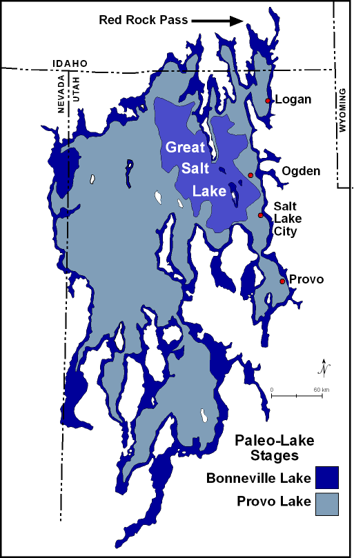
For thousands of years, Lake Bonneville was trapped inside the great basin, like water in a giant bathtub. It is believed that about 15,000 years ago lava flows in the vicinity of Pocatello, Idaho began to divert the bear river into Lake Bonneville. This Huge influx of water caused Lake Bonneville to overflow at Red Rock Pass. As material began to give away, a huge flood of water , about three times the flow of the Amazon River, Rushed into the Columbia River Basin and to the Pacific Ocean. This flood dropped the water level of Lake Bonneville by over 300 feet. However, it was at the end of the last ice age and the resulting change to a warmer and drier Great Basin climate 12,000 years ago that ultimately caused Lake Bonneville to evaporate and become the great Salt Lake.
Lake Bonneville was a large, ancient lake that existed from about 32 to 14 thousand years ago. It occupied the lowest, closed depression in the eastern Great Basin and at its largest extent covered about 20,000 square miles of western Utah and smaller portions of eastern Nevada and southern Idaho.
At its largest, Lake Bonneville was about 325 miles long, 135 miles wide, and had a maximum depth of over 1,000 feet. It contained many islands that are the present-day mountain ranges of western Utah. Its relatively fresh water was derived from dir ect precipitation, rivers, streams, and water from melting glaciers. During the time of Lake Bonneville, the climate was somewhat wetter and colder than now.
The Wasatch Mountain Range lies within the Wasatch-Cache National Forest along the Eastern border of the Salt Lake Valley Where the Rocky Mountains meet the Great Basin. The canyons are a glecial trough ("U" shaped canyon), carved by alpine glaiers during the last Ice Age (approximately 18,000 to 24,000 years ago). Glaciers and streams created Ferguson Canyon, leaving small waterfalls, streams and granite walls for climbing and hiking. http://geology.utah.gov/online_html/pi/pi-39/pi39pg01.htm
In order to log this cache you must fulfill a a couple of requirements.
1. Lake Bonneville was ____ miles long, ___ miles wide and had a maximum depth of more that _____ feet.
2 Many of Lake Bonneville's islands are present day _______ ______ of Western Utah.
3. Send a description of at least 2 examples of Lake Bonneville that you can see. An alternate to this question would be to post pics of 2 examples.