Landmannalaugar - Fjallabak Reserve EarthCache
Landmannalaugar - Fjallabak Reserve
-
Difficulty:
-

-
Terrain:
-

Size:  (not chosen)
Please note Use of geocaching.com services is subject to the terms and conditions
in our disclaimer.
Fjallabak Nature Reserve was established in 1979. The Nature
reserve is 47.000 hectares and is over 500 meters above see level.
The land is mountainous, sculptured by volcanoes and geothermal
activity, covered by lavas, sands, rivers and lakes...

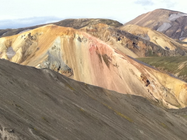
Landmannalaugar
Landmannalaugar is the largest rhyolite area
of Iceland.
Here can be found composite lavas and tephra. This rhyolite area is
a part of volcanic system named after Torfajökkul. The magma
belongs to the transitional rock series and the volcanic system is
active, having erupted during the Pleistocene and Holocene right up
to historical tmes. The system is part of the South Iceland
Volcanic Belt, where there is no plate rifting.
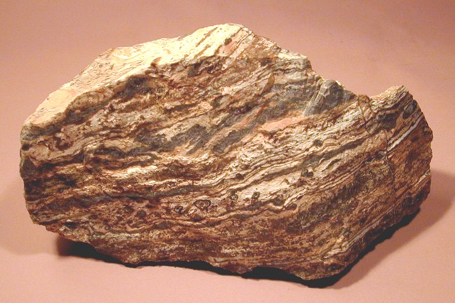
Rhyolite
Rhyolite is the most acidic eruptive rock and
very similar to dacite.
It is very light in colour, oftern cream coloured, microcrystalline
and seldom contains phenocrysts. Flow-banding is common and the
rock cleaves into this slabs. It is very like dacite and the two
rocks are difficult to distinguish in a hand specimen. However,
dacite does have a better ring, when struck with hammer. Iron oxide
precipitation is common and gives the rock a rusty – brown
colour. Rusty streaks and tongues are common, lending rhyolite
slabs and bright colour, and they are often used as a decorative
material in buildings.
More information
Bedrock of the Fjallabak Nature Reserve dates back 8-10 million
years. At that time the area was on the Reykjanes - Langjokull
ridge rift zone. The volcano has been most productive during the
last 2 million years, that is during the last Ice Age. Interglacial
lava (Brandsgil) and sub-glacial (erupted under ice/water, examples
being Blahnukur and Brennisteinsalda are characteristic formations
in the area. To the north of the Torfajokull region sub-glacial
volcanic activity produced the hyaloclastites (moberg) mountains,
such as Lodmundur and Mogilshofdar. Volcanic activity in recent
times (last 10.000 years) has been restricted to a few northeast ?
southwest fissures, the most recent one, the Veidivotn fissure from
1480, formed Laugahraun (by the hut at Landmannalaugar), Namshraun,
Nordurnamshraun, Ljotipollur and other craters which extend 30 km,
further to the north Eruptions in the area tend to be explosive,
previous known eruptions being around A. D 150 and 900. The area
sorrounding Torfajökull glacier and Landmannalaugar contains the
country's largest expanse of "most acidic eruptiv rock". It is very
light in colour, often cream coloured, microcrystalline and seldom
contains phenocrysts. It normally comes in grey, yellow, pink or
green colour. The name of this kind of lava is rhyolitic lava
Three major types of lavas
Types of lava: Erupted lavas, the end of volcanic geosystems,
usually solidify into one of the three major types of igneous
rock:
1. Basaltic lavas– Basalt is an extrusive igneous rock
of mafic composition (high in magnesium, iron and calcium) and has
athe lowest silica content of three ignous rock types, its
intrusive equivalent is gabbro. Basaltic magma is the most common
magma type. It is produced along midocean ridges and at hot spots
within plates, as well as in continental rift valleys. Basaltic
lavas erupt when hot, fluid magmas fill up a volcano’s
plumbing system abd overflow. Basaltic eruptions are rarely
explosive. On a land a basaltic eruption send lava downthe flanks
of volcano in great streams that can engulf everything in their
path. When cool, these lavas are black or dark grey, but at their
high eruption temperatures – 1000C – 1200C, they glow
in red and yellows.
2. Andesitic lavas– Andesit is an extrusive igneouse
rock with an intermediate silica content, its intrusive equivalent
is diorite. Andesitic magmas are produced mainly in the volcanic
mountain belts above subduction zones. The name comes from a prime
example the Andes. The temperatures of andesitic lavas are lower
then basalts, and because their silica content is higher, they flow
more slowly and lumo up in sticky masses plugs the central vent of
a volcano, gases can be build up beneth the plug and eventually
blow off the top of the volcano.
3. Rhyolitic lavas– this is very typical lava of the
sorrounding of Landmannalaugar. Rhyolite is an extrusive igneous
rock of felsci composition (high in sodium and potassium) with a
silica content greater then XX%. its
intrusive equivalent is granite. It is light in color, often a
pink, yellow or green color. Rhyolitic magmas are produced in
zones, where heat from the mantle has melted large volumes of
continental crust. Rhyolite has a lower melting point then
andesite, becoming liquid at temperatures only from yyy C - zzz C.
When the rhyolitic lava is cooled abruptly, the magma turns into
shiny black volcanic glass. You can find in the sorrounding of the
coords and on the way down to the camp many stones like that. How
is the name of this compact glassy rock which forms fragments with
a conchodial fracture pattern, often black?? This answer has nr. 3.
Questions for you:
1. WHAT IS XX ?
2. WHAT IS yyy C - zzz C ?
3. ANSWER nr. 3.?
4. WHAT IS THE NAME OF THE PEAK ON THE COORDS?
5. ON THE PIC nr.3 YOU CAN SEE THE SCENERY VISIBLE FROM THE COORDS.
WHAT IS THE DIRECTION OF THIS SCENERY?
6. WHAT YOU CAN FIND ON THE SUMMIT - close to coords?
7. NOT OBLIGATORY - BUT I APPRECIATE THE PICTURE OF YOU ON
COORDS

Additional Hints
(Decrypt)
Uvag gb gur dhrfgvba ae. 3 - lbh pna svaq va gur cubgbf