Mal's Photo Point EarthCache
-
Difficulty:
-

-
Terrain:
-
Size:  (not chosen)
Related Web Page
Please note Use of geocaching.com services is subject to the terms and conditions
in our disclaimer.
NOTE: Please consider bringing a hard-copy version of the
1958 image with you to Mal's Photo Point as this will provide the
opportunity to see what the view looked like in 1958 from the exact
location where you will be standing!
MAL'S PHOTO POINT:
About Mal's Photo Point:
Mal's Photo Point is an easily and quickly accessible EarthCache
with a small bump in difficulty due to a short section of off-trail
walking on rocks that can be slick in wet weather.
Stand in the same location where historic glacier photographs have
been taken and compare what you see with the images below!
“Mal’s Photo Point” A bit of
history:
Mal is the nickname of Dr. Maynard Miller, the long-time director
of the Juneau Icefield Research Program (JIRP). In early July of
each year, for many decades, Mal and the JIRP students and staff
would visit this spot and discuss the landscape surrounding you.
Before leaving, Mal would stand at the benchmark (near the
EarthCache) and take a photo of Mendenhall Glacier, thus
documenting the changes from year to year. We are excited that you
are in this special place and encourage you to enjoy and explore
the landscape around you, and invite you to contribute to the
record of repeat glacier photography from this location.
Mendenhall Glacier recession:
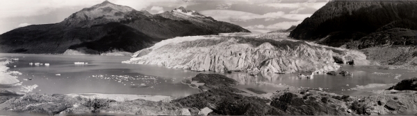
Photo: 1958, by Marrion T. Millett, National Snow and Ice Data
Center Glacier Photograph Collection
This 1958 panorama was taken from the location of this EarthCache.
Compare this image to what you see when you visit. What has changed
since 1958? What other than the glacier has changed?
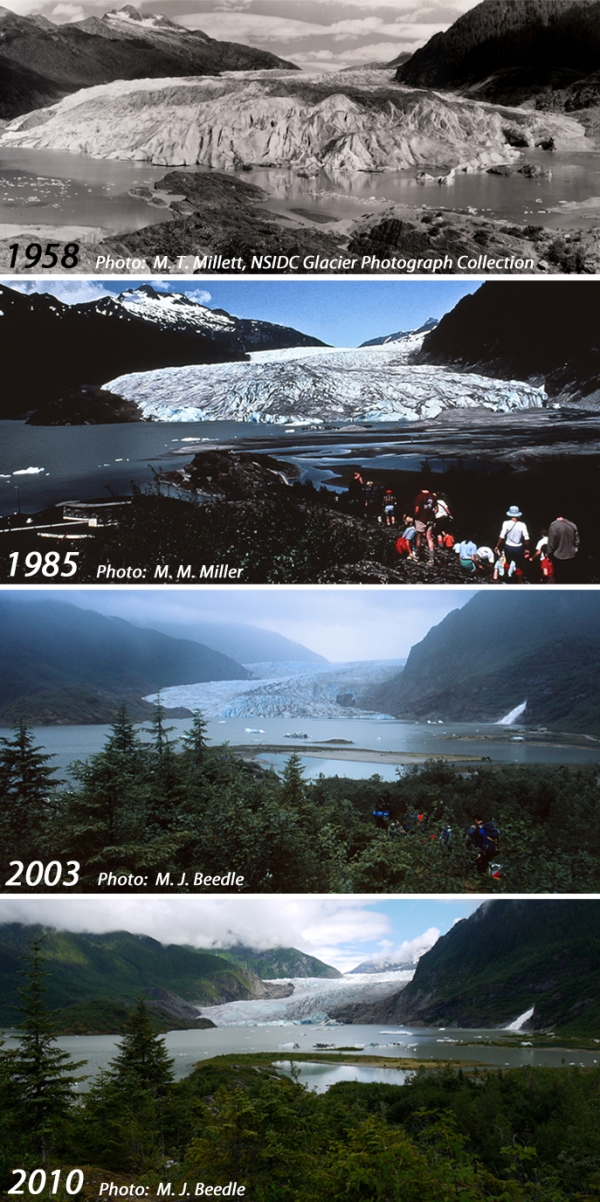
Repeat photography:
Repeat photography is used in many scientific fields to document
and quantify landscape change. Glacier repeat photography provides
a powerful visual of dramatic landscape change. The photos here
show how Mendenhall Glacier has receded since 1958.
Take a repeat photo from this location and help GlacierChange.org
document our changing glaciers.
When taking a repeat photograph take care to include all of the
common features that you see in the previous images: mountain peaks
and ridge lines (if it’s a clear day), common trees, Nugget
Falls, etc. Depending on vegetation growth you may need to change
location a bit to see the glacier.
If you do take a repeat image please upload it when
‘logging’ this EarthCache, and also consider submitting
the image to GlacierChange.org (connect@glacierchange.org) along
with the date and time you took the image.
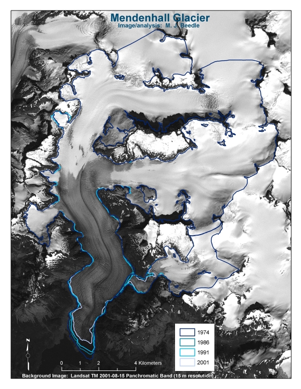
About Mendenhall Glacier and the Juneau Icefield:
Mendenhall Glacier is a 105 km2 (as of 2001) outlet glacier of the
Juneau Icefield. Outlet glaciers flow from a common, upper
elevation area where snow accumulates. The Juneau Icefield is
comprised of 53 outlet glaciers, totaling 3,176 km2. From 1991 to
2001 50 of these receded, two remained stationary, and one (Taku
Glacier) advanced. In total the Juneau Icefield lost 31 km2 from
1991 to 2001.
NOTE: Data regarding Mendenhall Glacier and Juneau Icefield
change comes from work in progress that was presented at the
International Workshop on World Glacier Inventory, 2008, Lanzhou,
China by M. J. Beedle and B. Raup. For more information:
beedlem@unbc.ca
Requirements for logging this EarthCache:
Please include answers to the following questions and complete
requested tasks:
1. How many people are in your group?
2. Take a repeat photograph of the glacier from the benchmark and
submit it when you log this cache. Be sure to note the date you
took the photo! An optional, additional photograph for submission
would be one of you and your group with Mendenhall Glacier in the
background.
3. Roughly how many icebergs do you see in Mendenhall Lake today?
What does the quantity and size of icebergs indicate about recent
Mendenhall Glacier change?
4. After a glacier recedes from a location it takes a number of
years or even decades for different types of vegetation to appear,
this is known as the ecesis interval. Assume an ecesis interval of
40 years for Sitka Spruce (Picea sitchensis) at this location. Find
the largest Sitka Spruce in the nearby vicinity of the cache and
estimate its age. The ecesis interval (40 yrs) plus the age of the
largest Sitka Spruce should give you the number of years this
terrain has been exposed. Subtract this number from the current
year to determine the year when the Mendenhall Glacier terminus was
at this location.
Current year – (40 + Estimated age of largest Sitka Spruce) =
????
What is the year you come up with?
Thank you for visiting Mal’s Photo Point!
For more information on Mendenhall Glacier, glacier change, and
glaciers in general please visit GlacierChange.org or contact us at
connect@glacierchange.org
Best wishes and happy adventures!
Additional Hints
(No hints available.)