*** CACHE IS NOT AT
THE LISTED COORDINATES ***
BACKGROUND:
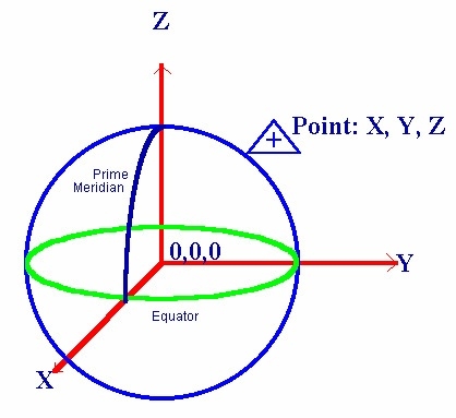
The Cartesian coordinate frame of reference used in the Global
Positioning System is called Earth-Centered, Earth-Fixed (ECEF).
ECEF uses three-dimensional XYZ coordinates (in meters) to describe
the location of a GPS user or a satellite. The term
"Earth-Centered" comes from the fact that the origin of the axis
(0,0,0) is located at the mass center of gravity (determined
through years of tracking satellite trajectories). The term
"Earth-Fixed" implies that the axes are fixed with respect to the
earth (that is, they rotate with the earth). The Z-axis pierces the
North Pole, and the XY-axis defines the equatorial plane.
ECEF coordinates are expressed in a reference system that is
related to mapping representations. Because the earth has a complex
shape, a simple yet accurate method to approximate the earth's
shape is required. The use of a reference ellipsoid allows for the
conversion of the ECEF coordinates to the more commonly used
geodetic-mapping coordinates of Latitude, Longitude, and Altitude
(LLA). Geodetic coordinates can then be converted to a second map
reference known as Mercator Projections, where smaller regions are
projected onto a flat mapping surface -- that is, Universal
Transverse Mercator (UTM) or the USGS Grid system.
THE CACHE:
To locate the cache container, simply convert the following ECEF
coordinates to LLA coordinates and you'll have the latitude and
longitude:
X = -744265.716362 meters
Y = -5463123.586763 meters
Z = 3195646.416260 meters
Once you've determined the actual location, you'll be looking
for a black magnetic nanocache that blends in well with its hiding
spot. Bring your own pen to sign the log. Have fun!
