Parco Naturale Tre Cime - Dolomiti di Sesto
Il Parco Naturale Dolomiti di Sesto non è solo noto per la sua grande varietà di piante ed animali, ma anche per le famose "Tre Cime" di Lavaredo.
Istituito nel 1981 il parco naturale si estende nella parte orientale dell’Alto Adige su una superficie di 11.635 ettari, comprendendo i comuni di Sesto, San Candido e Dobbiaco, fino alla parte nord-orientale delle Dolomiti, la Valle di Landro ed al confine con la provincia di Belluno.
Il due versanti della Valle di Sesto presentano una struttura geologica completamente differente: il versante orografico destro è infatti formato dai contrafforti occidentali del crinale carnico (Monte Elmo 2.434 m), costituiti da sciisti porfiroidi e tufi dolcemente ondulati e coperti di vegetazione e si spinge fino alle porte di San Candido; il versante orografico sinistro è costituito dalle propaggini nordorientali delle Dolomiti.
Dall'imbocco della valle al Passo di Monte Croce Comelico si susseguono tutte le formazioni geologiche tipiche delle Dolomiti. Su strati di dolomia della Mendola, ad esempio, si ergono crode molto accidentate ed erose, costituite da dolomia dello Sciliar, che si presenta in forme bizzarre (Gruppo di Croda e Rocca dei Baranci, Gruppo dei Tre Scarperi). Nel settore meridionale delle Dolomiti di Sesto la dolomia dello Sciliar costituisce la base litologica su cui poggiano i gruppi piú rappresentativi della catena, come Cima Undici (3.092 m), il Monte Popera (3.046 m), Cima Dodici (3.094 m), il Monte Paterno e le Tre Cime di Lavaredo, tutte vette facilmente riconoscibili per la loro struttura a banconate di dolomia principale.
Gli strati di Raibl, di dolomia grigia e strati di marne argillose vivacemente colorati, proteggono la sottostante dolomia dello Sciliar dall'erosione. Nelle depressioni laformazione di Raibl, costituita da strati impermeabili, ha consentito la creazione di splendidi laghi (Laghi dei Piani) o talora di verdi prati alpini. Il parco naturale comprende solo un lago di una certa estensione, il Lago di Landro nella omonima valle. Degni di nota sono alcuni laghetti poco profondi, come i laghi di Cime, dei Piani (Bödenseen) e di Malga di Mezzo (Mitteralplsee).
I poderosi torrioni di roccia che caratterizzano il paesaggio sono una breve parentesi nel dinamico processo che ha portato alla formazione delle Alpi e delle Dolomiti. In quest'area infatti, enormi ammassi detritici si staccano incessantemente dalle cime e depositandosi ai loro piedi formano estesi ghiaioni. In alcuni punti la Valle Campo di Dentro, la Val Fiscalina e la Val Rienza sono state invase in passato da enormi frane, con il conseguente interramento di alcuni torrenti, che tuttora scorrono in condizioni ipogee.
Le missione:
Col tempo la superfice della roccia dolomitica si sta consumando e leggermente, finendo nel aqua, sta cambinando il colore del aqua. Fai una descrizione breve del aqua del lago di Landro.
Quanti deflussi naturali ci sono?
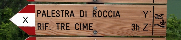
Ai piedi del Monte Paterno si trova il rifugio Antonio Locatelli. Trova sul panello info i dati relative all'altezza del rifugio e a quanto sono alte le tre cime del Lavaredo

Attenzione: I dati riportati sul cartello informativo potrebbero essere diversi da altre descrizioni (es. Wikipedia). Usare esclusivamente i dati riportati sul cartello informativo!
A fianco del cartello informativo (a sinistra) troverai la seguente insegna:
Invia le tue risposte alle domande via Email a X.Y.Z@googlemail.com e riceverai automaticamente il permesso per loggarti. I log che non hanno ricevuto il permesso o che contengono le risposte sbagliate verranno cancellati. Ci farebbe inoltre molto piacere vedere le vostre foto al lago di Landro allegate al vostro log (non è tuttavia obbligatorio per loggare la cache).
Naturpark Drei Zinnen - Sextner Dolomiten
Der Naturpark Sextner Dolomiten ist nicht nur für seine Tier- und Pflanzenwelt bekannt, sondern auch für die bekannten Bergspitzen "Drei Zinnen".
Auf 11.635 Hektar erstreckt sich seit 1981 der Naturpark von den Gemeindegebieten von Sexten, Innichen und Toblach bis zu den nordöstlichen Dolomiten, zum Höhlensteintal und an die Grenze der Nachbarregion Belluno.
Die beiden Flanken des Sextnertales sind geologisch unterschiedlich aufgebaut: während sich im Nordosten der westliche Ausläufer des aus sanft geformten, begrünten Porphyroidschiefern und Tuffen aufgebauten Karnischen Kammes mit dem Helm (2.434 m) bis vor Innichen schiebt, erheben sich auf der anderen Talseite die nordöstlichen Dolomiten.
Vom Talbeginn bis zum Kreuzbergpass begleitet uns die vollständige Schichtabfolge der Dolomiten. Über dem Mendeldolomit türmen sich die mächtigen, wild zerklüfteten Wände des Schlerndolomits empor, die vor allem der Haunold-, Dreischuster- und Birkenkofelgruppe ihr bizarres Aussehen verleihen. Mit der Haunoldgruppe reicht der Naturpark zudem direkt an die tektonische Bruchzone, die sogenannte "Pustertallinie", heran. Im südlichen Teil der Sextner Dolomiten bildet der Schlerndolomit hingegen nur den Sockel für die eigentlichen "Monumente" dieser Berggruppe: Der Elfer (3.092 m), die Hochbrunner Schneid (3.046 m), der Zwölfer (3.094 m), der Paternkofel (2.744 m) und die einzigartigen Drei Zinnen bestehen nämlich aus Dachsteindolomit.
Die Raibler Schichten mit ihren grauen Dolomiten und bunten Tonmergeln bedecken vielfach den Schlerndolomit und schützen ihn vor Erosion. In Mulden bilden sie die wasserstauende Unterlage für grüne Almmatten und schimmernde Seen (Bödenalm, Bödenseen). Der Naturpark weist nur einen größeren See, den Dürrensee (Lago di Landro) im Höhlensteintal auf. Landschaftlich bemerkenswert sind aber auch kleine und seichte Wasseransammlungen, wie die Zinnenseen, die Bödenseen und der Mitteralplsee.
Die Bergriesen, für uns der Inbegriff der Ewigkeit, sind nur eine kurze Momentaufnahme im dynamischen Entwicklungsprozess der Alpen und der Dolomiten. Dies beweist der Gesteinsschutt, der unablässig von Gipfeln, Graten und Wänden rieselt und sich an deren Füßen in mächtigen Halden aufstaut. Stellenweise wurde das Innerfeld-, das Fischlein- und das Rienztal verschüttet und manchmal verlaufen die Bäche unter dem Geröll.
Die Aufgabe:
Aufgrund des abgeriebenen Dolomitgesteins weist der Dürrensee eine besondere Färbung auf. Beschreibe das Wasser des Sees in kurzen Worten!
Wie viele natürliche Abflüsse hat der See?
Am Fuß des Paternkofels befindet sich die Drei-Zinnen-Hütte. Finde auf der Infotafel heraus, auf welcher Höhe sich die Hütte befindet und wie hoch die "Drei Zinnen" sind.
Achtung: Die angebenen Zahlen auf der Infotafel können von anderen Angaben (z.B. Wikipedia) abweichen. Maßgebend sind die Angaben auf der Infotafel!
Nahe der Infotafel findest du auf der linken Seite folgenden Wegweiser:
Schicke deine Antworten auf die Fragen an die eMail-Adresse X.Y.Z@googlemail.com und du bekommst automatisch die Logfreigabe. Einträge ohne Freigabe oder mit falschen Antworten werden gelöscht. Es wäre schön, wenn du ein Bild von dir am Dürrensee einstellen würdest (dies ist allerdings keine Voraussetzung für das Loggen deines Besuches).
Tre Cime - Dolomiti di Sesto Nature Park
This area in the east of South Tyrol is characterised by a rich flora and fauna and in especially by the formation called the "Drei Zinnen".
Since 1981, the Dolomiti di Sesto Nature Park - known as the "Sextner Dolomiten Nature Park" stretches from the municipalities of Sesto, San Candido and Dobbiaco to the north-eastern Dolomites, Valle di Landro and neighboring Belluno, covering an area of approximately 11.635 ha.
The two sides of the Sexten Valley are different from a geological point of view. On the north-eastern side there are the foothills of Karnischer Kamm including the Helm mountain (2.434 m). These gently shaped, green hills are made up of porphyroid slate and tuff. On the other side of the Sexten Valley , there are the north-eastern Dolomites.
Between the beginning of the valley and Kreuzbergpass the entire sedimentations of the Dolomites can be found. The Mendel Dolomite is followed by the imposing rock faces of Schlern Dolomite with its many crevices. The Haunold group, the Dreischuster- group and the Birkenkofel group owe their bizarre shape to this rock. The Haunold Group is situated at a tectonic fault line, the so called "Pustertal line". In the southern part of Sextner Dolomiten, the Schlern dolomite builds the base of some of the most impressive monuments of this mountain group: Elfer (3.092 m), Hochbrunner Schneid (3.046 m), Zwölfer (3,094 m), Paternkofel (2.744 m) and the unique Drei Zinnen are all made up of Dachstein dolomite.
The argillaceous Raibl Strata cover the Schlern dolomite in many places and protect it from erosion. In hollows, lush green mats and shimmering lakes can be found on the Raibl Strata (Bödenalm, the Bödenseen). This is due to their capacity to store great amounts of water. The Dürrensee (Lago di Landro) in the Höhlenstein Valley is the only bigger lake in the nature park. But there are several small and shallow ponds, such as Zinnenseen, Bödenseen and Mitteralplsee, which are of great scenic interest.
The huge mountain faces of Sextner Dolomiten convey a feeling of eternity to park visitors. Yet, they represent only one of the many phases in the dynamic process of development of the Alps and the Dolomites. This is proved by the rock debris which continuously drops of the peaks, ridges and rock faces. At the bottom of the mountains, this debris material can form large slopes. Some valleys, such as Innerfeldtal, Fischleintal and Rienztal have been partially submerged and many rivulets run under this debris.
The mission:
Based on the abrasion of dolomite the lake "Dürrensee" offers a specific colouration. Describe the water of the lake in few words.
How many natural outflows has the lake?
The "Drei-Zinnen-Hütte" is located at the bottom of the "Paternkofel". Use the information board to find out their altitude and the height of the "Drei Zinnen".
Attention: The given data on the information board may be different to other specifications (e.g. Wikipedia). Only use the data from the information board!
Next to the information board (on the left side) you'll find this marker:
Send your answers for the questions via eMail to X.Y.Z@googlemail.com and you'll get your log-permission automatically. Logs without permission or containing wrong answers will be deleted. It would be nice if you take a picture of you at the "Dürrensee" along with your log-entry (however this is not recommended for logging your visit).