
[CZ]
Na jiznich svazich Jestedskeho hrebene nad Padouchovem je jiz
nekolik let realizovan unikatni projekt: obnova dosavadni umele
smrkove monokultury do podoby, kterou zdejsi lesy mely nekdy pred
1000 lety, tj. do podoby bezzasahoveho porostu s druhovou
pestrosti stromu, bylin i zivocichu ve vsech prirozenych patrech
lesa, od prizemnich mechu a bylin po stalete stromy - velikany,
ktere se k zemi porouci az ve chvili, kdy prirozene nastane jejich
cas a ktere nasledne zustanou lezet v podrostu, aby poslouzily jako
vyziva i ukryt novym generacim hmyzu, ptaku, bylin i pristich
velikanu. Toho se obcanske sdruzeni Cmelak o.p.s. snazi dosahnout
tim, ze z dotaci sponzoru skupuje lesni pozemky, na nichz
postupne prorezava stavajici ekologicky nevyhovujici 'smrkovou
poust' a nahrazuje ji vysadbou sazenic tech druhu stromku, ktere tu
v minulosti sice rostly a maji v prirozenem stredoevropskem
lese sve misto, intenzivnim lesnim hospodarstvim zamerenym jen na
maximalni produkci dreva vsak byly vytlaceny. Zatim takto byla
zapocata premena na 35 hektarech lesa, spravovany prostor
pritom momentalne sestava ze 3 izolovanych casti, vzajemne
oddelenych dosavadnim, hospodarstvim silne poznamenanym a
ekologicky nevyhovujicim lesem. Nasledujicim cilem Cmelaka tak je
ziskani i techto pozemku a spojeni vseho do souvisleho prostoru,
kteremu je sice na zacatku s premenou v prales pomozeno, nasledne
by do nej vsak jiz nemelo byt zasahovano.
Stavajici les totiz pochopitelne neni optimalni ani zcela vykacet a
plosne nahradit novymi sazenicemi, ani jej nechat zcela bez pomoci
- oba postupy by sice take vedly k vysledku, nebot prales s
prevahou listnatych stromu je ve stredni Evrope stabilni formou
rostlinneho spolecenstvi, na niz by se jakykoliv prostor po
ukonceni "udrzby" clovekem postupne premenil, vhodnymi zasahy vsak
tento proces lze urychlit z radove stovek let na desitky: zatimco
paseka (i ta osazena) by nejprve zarostla plevelnymi bylinami
(ktere by sazenice buku stejne zastinily a zlikvidovaly), nasledne
plevelnymi rychle rostoucimi mekkymi drevinami (briza,...) a az o
hodne pozdeji a pomalu by se prosadily statne buky a jedle; naopak
neupravovana smrkova monokultura by nejprve musela pockat, az
odumrenim starych smrku vzniknou svetliny, ktere by mohly byt
obsazeny bylinami a semenacky novych stromu - pokud by se drive les
nasledkem kurovcove kalamity ci vichrice nezmenil prirozene na
paseku. Prumerne naklady na odkup pozemku a castecnou nahradu
puvodniho porostu novymi sazenicemi cini 8 Kc za 1m^2.
Protoze takovemuto "lesu v rekonstrukci" vstup slusneho
navstevnika neskodi - rostlinam a drobnym zivocichum na/v nich
zijicich jeho pritomnost nevadi, dokud je primo fyzicky
neposkozuje, a o pritomnosti plachych velkych dravcu si na takto
malem prostoru muzeme nechat jen zdat - a Cmelak pritom ziskane
dotace a granty nemuze z jejich titulu pouzit na nakup pozemku,
nybrz krome sveho provozu jen na vzdelavaci cinnost apod. -
vznikla zde naucna stezka, po niz vas tato multicache
provede.
Vsechny indicie jsou bez problemu zjistitelne z tabuli NS, vlastni
cache je pak umistena nedaleko jejiho konce v obvyklem ukrytu mimo
prales i uzemi podlehajici zvlastni ochrane - prosim zkuste pri
jejim hledani nepreryvat zbesile okoli.
PO CELOU DOBU SE CHOVEJTE K (PRA)LESU MAXIMALNE OHLEDUPLNE!!!
SNAZTE SE CHODIT STALE PO PESINE, NA NIC ZBYTECNE NESLAPAT, NIC
NETRHAT, NELAMAT!!!
***
Typ cache: puvodne melo jit o multi, ale protoze nema
zamerene stage (tabule NS), revirnik nepripustil nic jineho nez
mystery. Zacatek je na souradnicich v zahlavi, zadne
hlavolamy, potiz je hlavne najit cestu...
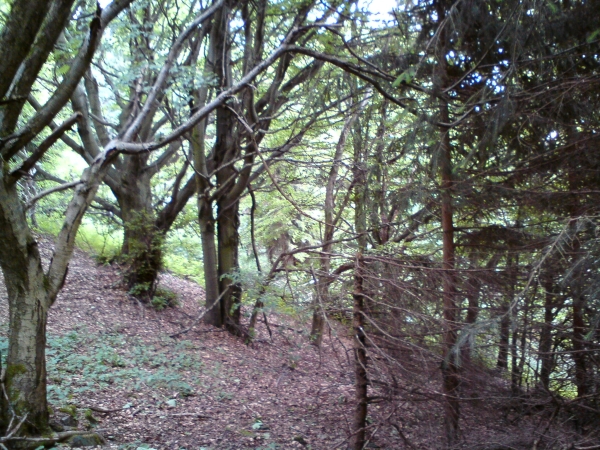
Teren: ona 'stezka' je v soucasnosti (cerven 2011) spise
ztracejici se neznacenou pesinou vedouci lesem v misty
prudkem svahu! Navic na zacatku i na konci musite prelezt dosti
vysoky plot, byt po zebriku! Takze na kola ci kocarky a snad
radeji i psy ci detske krosny protentokrat zapomente! Narocny
je i pristup k vlastni stezce - at uz odkudkoliv, vzdy to bude
nekolik kilometru a poradne dokopce.
Rozhodne sem nechodte pokud zde na hrebeni lezi souvisla snehova
pokryvka. Nenasli byste nejspis ani pesinu, ani cache.
Obtiznost: zadne rebusy ani zapeklite schovanou krabku
necekejte. Ale jak jiz bylo uvedeno, naucna stezka je
neznacenou ztracejici se pesinou 'pralesem'! Takze muze byt problem
vubec najit cestu a informacni tabule podel ni. Velmi doporucuji
vytisknout si mapku z galerie tohoto listingu nebo si ji
aspon obkreslit z tabule na zacatku stezky = na startovnich
souradnicich.
***
Start = 1. tabule NS: N 50°42.944 E 15°00.553
Sem se dostanete 'pohodlne' po modre turisticke znacce z
Plani na Rasovku.
Pokud nemate vytistenou mapku, durazne doporucuji
obkreslit si ji z tabule - pesina bude misty opravdu
nezretelna!
Pripraveni? Vypnete GPSku, dalsi souradnice dostanete az na konci.
Opustte sirokou cestu a vydejte se podel oplocenky dolu
skopce (do oplocenky zatim neprelezejte)
3. tabule: A = pocet savcu na vsech fotografiich (jen
fotografiich!; medved je zolik = pocitejte ho tolikrat (0 az
2) aby dohromady vyslo prvocislo)
U tabule prelezte do oplocenky a pokracujte vlevo zhruba po
vrstevnici; nikoliv tesne podel plotu, ale ani se od nej prilis
nevzdalujte! Jde o orientacne asi nejnarocnejsi usek... dalsi
tabule se pak nachazi par metru pod plotem.
4. tabule: B = pocet ptaku na vsech fotografiich (jen
fotografiich!)
Odtud pokracujte sikmo dolu svahem.
5. tabule: C = pred kolika lety priblizne to tu lide
opustili?
Pokracujte sikmo dolu svahem, pokud narazite na plot svahem dolu,
jdete zhruba podel nej, az plot uhne doleva - vy vzapeti uhnete po
zretelne pesine doprava, sikmo dolu...
6. tabule: D = kolik druhu netopyru a vrapencu zde bylo
objeveno?
Pod sebou jiz vydite vychod z oplocenky (jdete k nemu OKLIKOU PO
PESINE!!!) a pobliz posledni dve tabule.
Cache:
N 50 ° 42, [( A - B + C + D ) * 10 - 5]
E 15 ° 00, ( C * D / 2 + A - 9 * B )
[DE]
Auf den südlichen Abhängen des Jestedkamms wird schon seit
mehreren Jahren ein einzigartiges Projekt realisiert: Sanierung der
bestehenden künstlichen Fichtenmonokulturen zum Zustand, wie die
lokalen Wälder vor 1.000 Jahren aussahen, d.h. zum Zustand
eingriffloses Gewächses mit Artenvielfalt von Bäumen, Pflanzen und
Tieren in allen natürlichen Waldstockwerken, von niedrigem Moos bis
zu hundertjährigen Bäumen - die erst am Ende ihres Lebens auf den
Boden ohne Säge fallen und dann im Unterwächs liegen bleiben, um
als Nahrung sowie Versteck für neue Generationen von Insekten,
Vogeln, Pflanzen sowie zukünftigen hundertjährigen Bäumen zu
dienen. Um dieses zu erreichen, kauft die Vereinigung Cmelak
('Hummel') gradualmäßig die Waldgrundstücke in der Umgebung fürs
Sponsergeld ein, um dort die bestehende "Fichtenwüste" selektiv
abzuholzen und durch Anpflanzen von Setzlingen der Baumarten zu
ersetzen, die hier in der Vergangenheit wuchsen und in den
mitteleuropäischen Wald natürlich gehören, jedoch die durch
intensive Waldbewirtschaftung eliminiert wurden. Bisher hat diese
Umstellung auf 35 Hektaren vom Wald angefangen, dieses
Gebiet fasst nun jedoch 3 isolierte Teile um, also das nächste Ziel
ist auch das Land zwischen diesen voneinander getrennten Teilen zu
gewinnen um einen kontinuierlichen Raum zu schaffen, wo der
natürlichen Umstellung des Waldes zwar am Anfang geholfen wird,
dann soll der "Urwald" aber nicht mehr gestört werden.
Es ist nämlich optimal weder den bestehenden Wald völlig abzuholzen
und so entstandenen Aushau mit neuen Setzlingen anzupflanzen, noch
den Wald wie er nun ist ohne jegliche Hilfe zu lassen - obwohl
beide diesen Prozesse würden auch zu dem gewünschten Ziel führen,
da der Wald mit der Dominanz von Laubbäumen in Mitteleuropa die
stabilste Pflanzengesellschaft ist, zu der jeder Raum nach
eventuellem Schluss der "Wartung" von Menschen allmählich würde,
mit Hilfe geeigneter Maßnahmen kann dieser Vorgang von -Hunderten
auf Jahreszehnten gekürzt werden: während der Aushau (auch
angepflanzt) würde zunächst von Unkraut bewachsen (welches die
kleinen Buchen sowieso überschatten und eliminieren würde),
folglich setzten sich weichholzige Unkrautbaumarten (Birke usw.)
durch und erst langsam und viel später dominierten die Buchen und
Tannen; umgekehrt, unbehandelte Fichtenmonokultur müsste zuerst
warten, bis die überalteten Fichten fallen und somit kleine
Waldlichtungen entstehen, die von Pflanzen und Sämlingen neuer
Bäumen besetzt werden könnten - wenn der Wald nicht eher natürlich
durch den Borkenkäfer oder Sturm zum Aushau würde. Die
durchschnittlichen Kosten des Grunderwerbs und des teilweisen
Ersatzes des bestehenden Waldes mit neuen Bäumchen sind 8 Kronen
(0,35 Cent) pro Quadratmeter.
Weil so einem "Wald in Rekonstruktion" ein Eintritt von artigen
Besuchern nicht schädet - Gewächse und auf/in ihnen lebende
winzige Tiere werden erst dann gestört, wenn sie direkt physisch
gegriffen werden, und über Anwesenheit großer Raubtieren in diesem
kleinen Raum kann man nur träumen - und die Verwaltungsgesellschaft
darf die erhaltenen Subventionen und Zuschüsse nicht fürs
Bodenanschaffen ausgeben, sie können außer Betriebskosten nur für
Bildungsaktivitäten und ähnliche Zwecke benutzt werden - es ist
denn hier ein Naturlehrpfad entstanden, entlang welchem euch
dieser Multicache durchführt.
Alle Indizzen sind problemlos an den Lehrpfadschildern zu finden -
die Schilder sind sogar auch AUF DEUTSCH! Der Cache befindet
sich in der Nähe vom Ende des Lehrpfads außerhalb des Urwaldes
sowie der besonders geschützten Gebiete, in üblichem Versteck -
sowieso störe bitte seine Umgebung so wenig wie es nur möglich
ist.
VERSUCHE BITTE DEN (UR)WALD NICHT ZU BESCHÄDIGEN! Versuche immer
den Pfad nicht zu verlassen, auf die Pflanzen nicht zu treten,
nichts abzuzupfen, nichts zu brechen!
***
Cache-Art: Es sollte ein Multi-Cache sein, jedoch
weil es da keine Stage-Koordinaten gibt, musste er auf Mystery
geändert werden. Start ist auf den Header-Koordinaten, erwarte
keine Rätsel - das schwierigste ist den Pfad zu finden.
Terrain: dieser Naturlehrpfad ist derzeit (Juni 2011) eher
ein undeutlicher unmarkierter Pfad durch den Wald und
manchmal führt er in ziemlich steilem Hang! Außerdem muss man am
Anfang sowie am Ende einen ziemlich hohen Zaun überqueren
(mit Hilfe der Leiter)! Nehmt also diesmal lieber keine
Fahrräder, Kinderwagen, sowie auch Hunde oder Baby-Rucksäcke
mit! Auch der Zugang zu dem Lehrpfad ist ziemlich anstrengend -
woher auch immer, man muss mit mehereren Kilometern und vielen
Höhenmetern rechnen.
Komm hierher nicht solange der Kamm mit Schnee gedeckt ist!
Schwierigkeitsgrad: erwarte weder komplizierte Rätsel noch
besonderes Cache-Versteck. Jedoch wie bereits erwähnt, der Pfad
ist unmarkiert und undeutlich - es kann denn ziemlich anstrengend
sein, den Weg und die Tafel zu finden. Ich empfehle die Karte
von der Galerie da zu drucken und mitzunehmen oder mindestens
die an erster Tafel abzuzeichnen.
***
Start = 1. Tafel: N 50°42.944 E 15°00.553
Diese findet man direkt neben dem "comfortablen" blau markierten
Wanderweg zwischen Plane und Rasovka. Falls du keine
Lehrpfads-Karte mitgebracht hast, solltest du die an dieser Tafel
sicher abzeichnen!
Bereit? Schalt deinen GPS aus, verlasse den Forstweg und gehe an
dem Zaun bergab entlang (bleibe nun noch zaunauswärts)
3. Tafel: A = Anzahl der Säugetiere auf allen Fotos (nur auf
den Fotos!; zähle den Bär so viel mal (0 bis 2) damit du A =
eine Primzahl kriegst :-))
Quer nun das Zaun über und gehe links, bleibe dem Zaun nah,
jedoch gehe nicht direkt enlang ihm.
4. Tafel: B = Anzahl der Vögel auf allen Fotos (nur auf den
Fotos!)
Von hier aus gehe weiter schräg bergab.
5. Tafel: C = vor etwa wie vielen Jahren haben die Menschen
aufgehört diese Grundstücke zu kultivieren?
Gehe weiter schräg bergab, falls du bis zum Zaun kommst, gehe
entlang ihm bergab und nachdem es nach links abspringt, solltest du
einen schon gut sehbaren Pfad nach rechts schräg bergab finden.
Gehe entlang ihn...
6. Tafel: D = Wie viele Fledermausarten leben hier?
Hier siehst du schon unter dir den Ausgang aus dem Zaun (gehe
entlang dem Fußweg dorthin!) und die letzten zwei Tafeln in
seiner Nähe.
Cache:
N 50 ° 42, [( A - B + C + D ) * 10 - 5]
E 15 ° 00, ( C * D / 2 + A - 9 * B )
[EN]
On the southern slopes of the Jested ridge an unique project has
been realised since the last several years: rehabilitation of the
current artificial spruce monocultures to the state, how the local
forests looked like some 1,000 years ago, i.e. to the state of
intervention-free jungle with variety of trees, plants, as well as
animal species living in all the natural 'floors' of the jungle,
from several centimeter high moss up to ancient giant trees which
fall down without being helped by a saw only when their time really
comes and which then stay laying in the undergrowth to serve as
food as well as hiding place for new generations of insects, birds
and plants including future tree giants. To achieve this, the
organisation Cmelak ('Bumbelbee') uses donated money to
gradually buy forest land in this area to help the forest there to
rehabilitate: existing "spruce desert" is selectively cut down and
replaced by seedlings of tree species which used to live here
and which definitely belong to the natural Central-European forest,
but which were eliminated by intensive forest exploitation in the
past centuries. So far the rehabilitation on the area of 35
ha has been initialised, however, it now 'consists' of 3
smaller parts separated by the 'ill' woods, so the next goal is to
acquire this land as well to be able to form continuous space where
the transformation is artificially initialised / speeded up but
then the 'jungle' shall not be disturbed any more.
Because actually it is optimal neither to cut the existing forest
completely down and plant the cut-over with new seedlings, nor to
leave the recent forest as it is without any help - yet both these
processes would lead to the desired state, as in the Central Europe
the forest with a dominance of deciduous trees is the most stable
plant community, to which each undisturbed stand would gradually
converge if the 'maintenance' by man were abolished, by taking
reasonable measures this process can be shortened from hundreds of
years to decades: whie a cut-over (even if planted but not
maintained) is first overgrown by herb weeds (which would
overshadow and eliminate the small beech trees and another slowly
growing trees anyway), followed by quickly growing soft-wood weed
tree species (birch etc.) and only slowly and much later the
beeches and firs dominate; vice versa, untreated spruce monoculture
would first have to 'wait' until some overseasoned trees fall down
and thus create small clearings that can be settled by new plants
and tree seedlings - if whole the forest would not turn into a
cut-over naturally thanks to bark beetle or storm. The average
costs of acquisition of 1 m^2 of recent woods and of partial
replacement of the overgrowth are 8 CZK (0,35 EUR).
Since respectable visitors are no thread for such a 'forest
under reconstruction' - the vegetation as well as the tiny animals
living on / in them would be disturbed only by direct physical
attack and the presence of large predators in such a small area is
unreal - because the management association must not use the
subsidies and grants received as an operation funds to acquire the
land, but it may use it to finance e.g. educational activities,
this nature trail has been built and now you can gain a
multi-cache point for passing it.
All clues can be found easily on the info-boards, the cache is
located near the end of the nature trail, outside the 'jungle' as
well as outside any specially protected areas, however, please
disturb its surroundings as few as possible anyway.
THE TABLES ARE ONLY IN CZECH AND GERMAN. BUT YOU SHALL BE ABLE TO
FIND THE ANSWERS ON THEM EVEN IF YOU DO NOT UNDERSTAND ANY OF THESE
LANGUAGES...
***
Cache Type: it should have been a Multi, but as there
are no coordinates of the stages here, I was not allowed to let it
be a Multi. You shall start on the Header Coordinates and there
are no field puzzles, the most demanding thing is not to get
off the path.
Terrain and accessibility: the 'trail' has recently had
(June 2011) rather the shape of hardly recognizable path leading
through the woods, sometimes in a pretty steep slope! On both
its ends you need to cross quite a high fence - there are
ladders, but... So do not come with bikes, baby carriages and
rather also without dogs or baby-backpacks. Quite demanding is
the access to the trail as well - regardless of where you arrive
from, you need to count with several kilometres of walk and much
climbing. Do not go here if the ridge is snow-covered!
Difficulty: expect neither demanding puzzles nor treacherous
cache hide. But count with the fact, that the trail is an
hardly recognizable path! So you can get into trouble while
tracking the path and searching for the info-tables along it. I
strongly recommend you to print the map in this listing or at
least copy that one which you can find on the first table.
***
THE TABLES ARE ONLY IN CZECH AND GERMAN. BUT YOU SHALL BE ABLE TO
FIND THE ANSWERS ON THEM EVEN IF YOU DO NOT UNDERSTAND ANY OF THESE
LANGUAGES...:
Start = Table #1: N 50°42.944 E 15°00.553
This one stands just next to a blue marked hiking trail from
Plane to Rasovka.
Copy the map (unless you have printed it at home), turn your
GPS off, leave the road and go down the hill along the
fence. Do not cross it now.
Table #3: A = number of mammals on all the photos here (only
on the photos! count the bear so many times (0 to 2) you need to
get A = a prime number :-))
Now cross the fence and continue to the left approx. flatly;
not directly along the fence - a bit to the right - but do not go
too far from it. This is perhaps the most demanding part of the
trail... The next table is situated close to the fence.
Table #4: B = number of birds on all the photos here (only
on the photos!)
Go on sidelong down the hill.
Table #5: C = first number (two-ciphered) in the German (orange)
text - it says how many years ago have the farmers abandoned
this land.
Go on sidelong down the hill, if you come to the fence, go down the
hill along it until the fence turns left. Here you shall find a
good path to the right, sidelong down the hill - go along it.
Table #6: D = the number (two-ciphered) in the German (orange)
text - it says how many species of bats live in this
area.
Continue along the path to the ladder, where you exit the
fence.
Cache:
N 50 ° 42, [( A - B + C + D ) * 10 - 5]
E 15 ° 00, ( C * D / 2 + A - 9 * B)