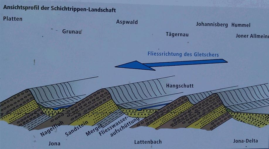
Schichtrippenlandschaft
Die gigantischen Eisgletscher schliffen Rippen aus der ursprünglichen Landschaft heraus. Nur die widerstandsfähige Nagelfluh blieb erhalten. Weichere Schichten wurden als u-förmige Täler ausgeschürft. Danach konnten Bäche und Flüsse enge V-Täler ins Gestein fressen. Bei geringem Gefälle schütteten sie Ebenen auf (Linthebenen) oder bildeten im See Deltas.
Findlinge sind Relikte aus der Eiszeit
Die großen Steinblöcke sind von den eiszeitlichen Gletschern aus den Alpen herausgetragen worden und geben uns heute Auskunft über die Fliesswege des Eises.
Stein (geschichten)
Was können uns Steine alles erzählen? Zum Beispiel etwas über Ihr Alter, wie sie entstanden sind, was sie unverwechselbar macht und noch vieles mehr…

Vor dir siehst du für diese Region typische Gesteinsschichtung aus sich abwechselnden Nagelfluh- bzw. Sandsteinschichten.
Was ist passiert?
Vor 15 bis 10 Millionen Jahren lagerte der Ur-Rhein an dieser Stelle riesige Mengen von Geröll, Sand und Schlamm ab. Diese Ablagerungen hatten teilweise eine Dicke von mehreren hundert Meter. In den folgenden Jahrmillionen wurde daraus Feldgestein. Aus dem Geröll wurde Nagelfluh, aus dem Sand Sandstein und aus dem Schlamm Mergel.

Im Zuge der Alpenbildung wurden die Erdmassen durch enorme tektonische Kräfte aufgestapelt und aufgerichtet oder wie in Randzonen – beispielsweise im Raum Jona- auch nur schräg gestellt.
Schaue dir die vor Ort die Findlinge aus dem Aspwald an und beantworte folgende Fragen:
Schickt bitte vor dem Loggen Eure Antworten an meinen GC-Account und loggt direkt online; ich melde mich, falls es Probleme mit den Antworten geben sollte. Logs ohne Antwortmail werden gelöscht.
- Wie alt ist der Alpenkalk?
- Wie weit wurde der Quintner Kalk durch den Gletscher transportiert?
- Schätz den Umfang des Findlings „Kalk-Nagelfluh“
Über ein Bild mit Euch und Eurem GPS, würde ich mich freuen. Die Bilder an den Internet-Log anfügen. (Laut Earthcache Guidelines ist die Forderung eines Fotobeweises seit Juni 2019 wieder erlaubt.)
Ihr dürft mit dem absenden der Antworten gleich loggen. Bei Problemen melde ich mich!
Layer ribs landscape
The huge ice glaciers ground out ribs from the original landscape. Only the tough Nagelfluh remained. Softer layers were ausgeschürft as u-shaped valleys. Could then narrow creeks and rivers feeding into the V-valley rock. At low levels to fall they poured (Linth levels) or formed in the lake deltas.
Boulders are remnants from the Ice Age
The huge stone blocks have been carried out by the ice-age glaciers of the Alps today and give us information about the flow path of the ice.
Stone (stories)
What we can tell everything stones? For example, something about your age, how they originated, what makes them unique and much more ...
Front of you are typical for this region of alternating layers of rock or conglomerate-sandstone layers.
What happened?
Was 15 to 10 million years ago deposited the Ur-Rhine at this point vast quantities of gravel, sand and mud. These deposits were in part a thickness of several hundred meters. In the following year it was millions of field stone. From the rubble was Nagelfluh, out of the sand from the sandstone and marl mud.
During the Alpine orogeny the masses of earth were piled up by huge tectonic forces and erect or, as in peripheral areas - for example in the space-Jonah also made only obliquely.
Look at the site of the boulders from the Aspwald and answer the following questions:
The questions:
1) How old is the alpine limestone?
2) How much of Quintner lime was transported by the glaciers?
3) Estimate the size of the boulder "lime Nagelfluh"
The questions are all solved on the spot, based on the boulders that lie on the ground
About a picture with you and your GPS, I would be happy. The pictures on the web log to attach. (According to the Earthcache Guidelines, the requirement for photo evidence has been allowed again since June 2019.)
You can log your visit directly, if there are any problems, i'll contact you ...