Ristinge Klint EarthCache
-
Difficulty:
-

-
Terrain:
-

Size:  (other)
Please note Use of geocaching.com services is subject to the terms and conditions
in our disclaimer.
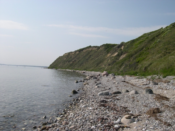
Ristinge Klint er en 2 km lang og op til 30 m høj klint, der viser en 130.000 år lang historie, fordi der her er blotlagt lag fra både Saale-istiden og fra Eem-mellemistid. Klinten er enestående i Europa fordi lagene står på højkant. Lagene er blevet skubbet op på højkant af isen under den sidste istid. De består af skiftevis Moræneler (hårdt) og sand (blødt). Denne sammensætning giver klinten et helt specielt udseende både set fra stranden og set oppefra.
På Ristinge Klint består leret hovedsageligt af Cyprinaler. Cyprinaler er speciel fordi den består af skaller fra muslinger og snegle, der har levet i tempereret klima. I mellemistiden mener man, at temperaturen ved Ristinge har været som den er i dag er ved de Sydfranske kyster.
På grund af den specielle jordsammensætning, og da klinten er sydvendt, kan man her finde planter, der normalt ikke gror side om side. Forholdene er også gode for mange krybdyr, f.eks. støder man ofte på Markfirben (Lacerta Agilis).
For at logge cachen, skal du gøre følgende:
1. Der står et skilt på 0-punktet. På skiltet er der et billede af et dyr. Hvilket?
2. Lav en tegning af klinten set fra luften. Behøver ikke at være detaljeret.
3. Forklar med dine egne ord, hvorfor du tror, at klinten ser ud som den gør.
4. På skiltet sammenlignes gletcheren med et stykke "værktøj" - hvilket?
5. Mål hvor højt over havet du står, når du står ved 0-punktet.
6. Tag et billede at dig selv eller din gps ved bænken på 0-punktet med havet baggrunden. Valgfrit - men vi bliver glade, hvis du gør det.
Send svarene til os på mail via vores profil. Tegning og evt. foto uploades på logningen.
Du er velkommen til at logge dit fund. Vi kontakter dig, hvis dit svar ikke er korrekt. Logninger uden svarmail vil blive slettet.
English:
Ristinge Klint is 2 km's long and 30 m high at the highest point. The cliff shows a 130.000 year long history, as it contains layers from both the Saale ice age and the Eem interglacial period. The cliff is unique in Europe because the layers are horisontal. The layers have been pushed by the ice during the last ice age. It consists of Till (hard) and sand (soft). This compination leaves the cliff with at very special apperance that you can see from both the beach and when you stand on top of it.
The clay at Ristinge is mainly Cyprina. This type of clay contains shells from mussels and snails living in temperate climate. During the interglacial period the temperature at Ristinge was as it is by the coast of Southern France today.
Because of the unique combination in the soil, and because the cliff is to the south, plants that usually grow in different places grow side by side. The conditions are also ideal for many reptiles, eg. you often see the Sand Lizard (Lacerta Agilis) here.
To log this cache your have to:
1. The sign at coordinates has a Picture of an animal. Which animal?
2. Draw a scetch of the cliff seen from above. You don't need a lot of details.
3. Explain in your own words, why you think the cliff looks the way it does.
4. The glacier is compaired to a "tool" in the sign. Which one?
5. Measure how much above sea level you are standing at the coordinates.
6. Take a picture of you or your gps by the bench looking over the ocean. Optional - but we will be very happy if you do.
Plase mail your answers using our profile. Upload the drawing and photo with your log.
Feel free to log your find. We will contact you, if the answers are not correct. Logs without answer mails will be deleted.
Additional Hints
(No hints available.)