NIMRODSKY RINGVAL
Tato jednoducha kes Vas privede do casti
chranene krajinne oblasti Slavkovsky les v kopcich nad Marianskymi
Laznemi, do mist kde vede historicka kupecka stezka, zvana
Kralovska. Na uvedenych souradnicich mimo kese naleznete také
terenni ukaz nazyvany ringval(na miste samotnem je oznaceno jako
Straziste. A protoze blizko tohoto mista se jeste v nedavne
minulosti nachazela vyhlasena vyletni kavarna NIMROD, je tento ukaz
pojmenovan Nimrodsky ringval.
K jeho objeveni a zdokumentovani prispel pred
nekolika desitky let (1976) pan Bohumil Broukal z Melnika, ktery
inicioval vlastivedna patrani vseho druhu, v terenu, v knihovnach,
v archivech, nebot byl presvedceny o tom, ze prastara stezka Via
Regia pres Slavkovsky les je keltskeho puvodu a ringvaly na této
ceste mohly slouzit kupcum a obchodnim karavanam k prenocovani,
resp. jako straziste. Stredoveky puvod tohoto místa potvrdil pri
svém archeologickem pruzkumu téz dr. Pavel Sebesta z Chebu. Dalsim
pruzkumem, ktery provedl Zdenek Buchtele, byly archeologickou
sondou v miste ringvalu nalezeny ploche kameny, snad jakési
dlazdeni a dale nekolik strepu stredovekeho puvodu.
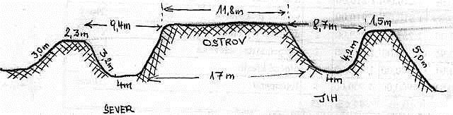
Ucel a puvod ringvalu zustal dosud zahadou a
proto existuje vice hypotez. Ringval nad Nimrodem ma prumer
ostruvku 12 metru, sirku prikopu na hrebenech 9 metru, hloubku
prikopu 2,3 metru a dno prikopu cca 4 metry. Vnejsi kruhovy val ma
v prumeru 30 metru. Tyto male rozmery ringvalu vedou k domnence,
zda nejde jen o straziste pri stezce, proto oznacení "kruhové
straziste". Rozryte okoli v bazinatem terenu potvrzovalo, ze kdysi
tu byl na stezce cily davny ruch. Odborná literatura ovsem udava,
ze takovych ringvalu se naleza mnoho v prilehlych oblastech Saska
(Vogtlandu), Bavorska, ale i na Assku. Rozmery jsou ruzne, vzhled
tyz;. Kruhovy val s prikopem a uprostred ostruvek. Nekde je jste
prikop naplnen vodou.
Zdroj: http://www.hamelika.cz/
A ted jak se dostat na misto ulozeni:
Na uvodiních souradnicich je turisticky rozcestnik pro cervene
znacenou turistickou stezku. Z tohoto rozcestniku zjistite
následujici udaje A = vyska mista Straziste v metrech nad morem, B
= vzdalenost ke Strazisti v metrech. Nyni uz staci jen dosadit
zjistene udaje do následujiciho vzorce N50° 01.A-460, E012°
42.770+B
AN / NIMRODSKY RINGVAL
This simple cache will bring you to the
protected area of the Slavkov Forest in the hills of Marianske
Lazne, in places where the trail leads historic merchant, called
"Royal". In those coordinates can also be found among the cache off
phenomenon called "ringval" (on the site itself is marked as
Stráziste). And because near this point is still found in the
recent past, famous cruise cafe Nimrod, this phenomenon is termed
"Nimrodsky ringval.
His discovery and documentation of donated
several decades ago (1976) Mr. Bohumil Broukal from Melnik, who
initiated the quest for natural history of all kinds - in the
field, in libraries, archives, because he was convinced that the
ancient Via Regia trail through the Slavkov Forest to ringvaly
Celtic origin, and on this journey to serve buyers and trade
caravans to stay overnight, respectively. as Stráziste. The
medieval origins of the place confirme in his archaeological survey
also dr. Paul Sebesta from Cheb. Another survey conducted by Zdenek
Buchtel, the archaeological site ringvalu probe found flat stones
and perhaps some cobbles and a few shards of medieval origin.
Ringvalu purpose and origin remain a mystery and
so far there are several hypotheses. Ringval the Nimrod has a
diameter of island 12-meter wide trench on the ridge of 9 meters,
2.3 meters deep trench and the bottom of the ditch about 4 feet.
External circular mound has a diameter of 30 meters. These small
dimensions ringvalu lead to believe that not only Stráziste the
trail, thus marking the circular Stráziste. Rozryté around in a
marshy field confirm that there once was an old trail gay tourism.
The professional literature indicates, however, that such ringvalu,
there are many in the surrounding areas of Saxony (Vogtland),
Bavaria, but also Aš. The dimensions are different, look the
same. A circular mound with a moat and island in the
middle.Sometimes it is even a moat filled with water.
>
Source: http://www.hamelika.cz/
And now how to get to save the cache:
The initial coordinates for the tourist signpost red tourist trail.
From the crossroads you'll find the following information and
Straziste = elevation in meters above sea level, B = distance in
meters to Strázisti. Now I just need to install the data found in
the following formula N50° 01.A-460, E012° 42.770+B