The Cuyahoga River, which in the Iroquois language means "crooked river" and is most famous for being "the river which caught fire", begins it's winding journey in Geauga County and 85 miles later empties into Lake Erie at Cleveland, about 35 miles west of it's headwaters.
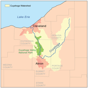
This winding journey takes the river south towards Kent, Munroe Falls, and then to Akron, where it turns sharply North and flows through the Cuyahoga Valley National Park. It then flows through the southern suburbs of Cleveland and finally at Cleveland it empties into Lake Erie.
----
The recent history of the Cuyahoga River at Munroe Falls began in 1809, when an estimated 40 people traveled from Connecticut and settled next to a river. The settlers called their new village Kelsey's Mills. The name reflected the primary businesses that set up shop on opposite banks of the river, a gristmill and a sawmill, using the water power of the river.
The first report of a dam in Munroe Falls was 1817, the same year that the name of the village was changed to Florence. In 1836 William and Edmund Munroe arrived from Boston, purchased 200 acres of land, and changed the name of the village to Munroe Falls.
Several dams were constructed at the site over time, providing power and process water to paper mills for over 100 years. The most recent dam was constructed of sandstone blocks, stood about 12 1/2 feet high, and had "1903" carved into some of the blocks.
By the end of the 20th century the dam was in disrepair and no longer being used for industrial purposes. There were problems with the river caused by the flow of the river being too slow. It was determined by the Summit County's Department of Environmental Services (DOES), in cooperation with the Ohio Environmental Protection Agency (OEPA), that it was necessary to improve the flow of the river. Increasing the flow of the river would increase oxygen levels, and create a healthier river and aquatic environment. After considering all of the alternatives, it was decided to remove the dam.
By the end of 2005 the dam had been removed and for the first time in almost two-hundred years the river was free flowing. The large sand stone blocks that are part of the amphitheater and the river overlook are from the dam.
A number of changes to the area have occurred since the dam was removed. And, some of these can be found on the two informational signs in the area. And, this information will help answer the questions that must be answered to claim a find.
One of these changes that isn't mentioned on the informational signs, is that the rapids have returned. But, depending on the water level, sometimes they are there and sometimes they are not. One of the improvements that the rapids have brought to the river is increased oxygen level.
There are 6 classifications of rapids:
- Class 1: Very small rough areas, requires no maneuvering.
- Class 2: Some rough water, maybe some rocks, small drops, might require maneuvering.
- Class 3: Whitewater, medium waves, maybe a 3–5 ft drop, but not much considerable danger. May require significant maneuvering.
- Class 4: Whitewater, large waves, long rapids, rocks, maybe a considerable drop, sharp maneuvers may be needed.
- Class 5: Whitewater, large waves, continuous rapids, large rocks and hazards, maybe a large drop.
- Class 6: Whitewater, typically with huge waves, huge rocks and hazards, huge drops, but sometimes labeled this way due to largely invisible dangers.
----
To log this Earthcache:
Visit Brust Park, and email me the answers to the following questions within 5 days of your visit or your log, per EarthCache policy, must be deleted. DO NOT post your answers in your log.
- 1. Describe, in a sentence or two, what the mood of the river is on the day of your visit. (i.e. is it slow, or fast, or at flood, or frozen, or what?) Also, feel free to post a picture showing the rivers mood, and include yourself, or your crew, in the picture if you like.
- 2. Estimate the width of the river, at the time of your visit, at the observation deck.
- 3.
What two (2) fishes help to show that the river is clean? Not a required answer at this time
- 4.
What was one of the things that showed that the river was in trouble and has been eliminated by the removal of the dam? Not a required answer at this time
- 5. If the rapids are present, what class are they? If they are not present, why?
- 6. What are "riffles" and what do they do? ( Google may be your friend here)
----
Congratulations to Dame Deco for the First To Find!
