
 This
EarthCache is located at the base of an alluvial fan near Badwater.
There is no official parking area, so be sure to pull completely
off the pavement when parking.
This
EarthCache is located at the base of an alluvial fan near Badwater.
There is no official parking area, so be sure to pull completely
off the pavement when parking.
As with all locations in National Parks, everything is
protected, so leave it as you found it.
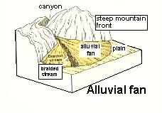 The steep mountain slopes and narrow valleys of
the mountain ranges on either side of Death Valley produce a lot of
sediment during the short intense precipitation events common to
the area. Sediment is eroded from the barren mountain ranges and
transported out of the mountains through relatively narrow canyons.
Image from wrgis.wr.usgs.gov/docs/usgsnps/ deva/9ADV-2.jpg (no
longer active)
The steep mountain slopes and narrow valleys of
the mountain ranges on either side of Death Valley produce a lot of
sediment during the short intense precipitation events common to
the area. Sediment is eroded from the barren mountain ranges and
transported out of the mountains through relatively narrow canyons.
Image from wrgis.wr.usgs.gov/docs/usgsnps/ deva/9ADV-2.jpg (no
longer active)
Water traveling in the narrow canyons moves quickly and carries
a lot of sediment, especially during flash floods. When the water
reaches leaves the narrow canyon, it is no longer confined so it
spreads out, slows, and drops its sediment. Over time this
generates a buildup of sediment at the mouth of the narrow canyons
that spreads out relatively evenly in all directions. When viewed
from the air, it looks like a fan, with the central point at the
mouth of the canyon.
There is also a pattern to the size of the sediment in an
alluvial fan. Near the mouth of the canyon where the water is still
moving quickly, there are large boulders. As you move out into the
valley, the size of the sediment gradually gets smaller and
smaller. By the time you get to the valley floor, there is only
small sand and silt. This is because the size of the particles
water can transport decreases as its velocity decreases. Once the
water reaches the lower slope of the alluvial fan, the water slows
and the larger particles fall out of the water.
On the east side of Death Valley are a series of alluvial fans.
You are parked near the bottom of one. To the north past Badwater,
two others can be seen.
Over time, these alluvial fans grow out away from the mouth of
the source canyon. Given enough time, the alluvial fans merge and
appear as one large apron at the base of the mountains. At this
point, the land form is called a bajada. The base of mountains on
the western side of Death Valley (across the valley from the
coordinates) is covered by a bajada.
Logging requirements:
Send me a note with:
- The text "GC2V50H Alluvial Fans and Bajadas in Death Valley "
on the first line
- The number (including non-cachers) and names of the geocachers
in your group.
- Describe the change in particle size between the area upslope
of the coordinates and downslope?
- What characteristic of the eastern side of the valley (the one
you are on) shows that it is not a bajada.
The following sources were used to generate this
cache:
- Spear, Steven G. Ph.D., 2009, Death Velley
Geology, A Field Guide and Virtual Tour of the Geology of Death
Velly National Park and Environs, California and Nevada, Last
Updated: August 25, 2009
http://www.palomar.edu/geology/DVWeb.htm
- wrgis.wr.usgs.gov/docs/usgsnps/ deva/9ADV-2.jpg
(no longer active)