[CZ]  Hracholusky je prehradni nadrz v okresech Tachov a Plzen sever. Ma rozlohu 470 ha a maximalni hloubka je 31 m. Pres prehradu vede Pnovansky most. Jeji soucasti je sypana hraz o delce 270 m a sirce v korune 5 m a vysce priblizne 26,5 m. Kvalitu vody je mozne zjistit na Krajske hygienicke stanice: Vodni nadrz Hracholusky - Hraz, Vodni nadrz Hracholusky - Radost.
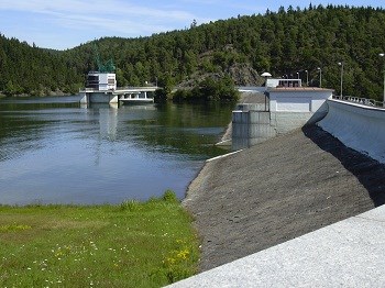
Vodni dilo Hracholusky bylo vybudovano v letech 1959 - 1964 na rece Mzi, ktera prameni v Ceskem lese a vteka do Berounky. Prehrada je zasobnikem vody pro prumyslove, energeticke a zemedelske vyuziti v Plzenskem kraji. Slouzi take k castecne ochrane pred povodnemi.
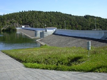
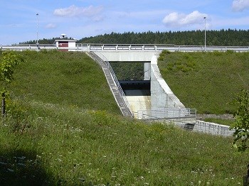
Hraz je vybudovana jako zemni sypana se sikmym jilohlinitym tesnenim v navodni casti. Navodni lic je chranen dlazbou z betonovych prefabrikatu a vzdusni strana je zatravnena. V leve casti hraze je vybudovan sdruzeny vezovy objekt, ktery obsahuje malou vodni elektrarnu s Kaplanovou turbinou, ovladani dvou uzaveru vypustneho zarizeni a sachtovy preliv. Ale vice o vodni elektrarne si povime v dalsi casti listingu. Hlavnim ucelem tohoto vodniho dila je akumulovat vody pro prumyslove, energeticke a zemedelske vyuziti v zapadoceskem regionu. Dale slouzi k castecne ochrane uzemi pred ucinky velkych vod. Blizkost mesta Plzne i hranice se SRN zvysuji vyuzivani vodniho dila take k rekreaci. Na nadrzi je vyhlasen rekreacni rad, zvlaste pro soustredenou rekreaci v oblastech Butov, Hracholusky a Radost.
Priroda kolem a geologie
Hracholusky jsou obklopeny Krivoklatskymi lesy a radou chranenych prirodnich oblasti. Vedle zakonem chranenych rostlin koniklec, netresk, taricka skalni, rozchodniky a lomikameny muzete v okolnich lesich nalezt i vzacne dreviny jako jerab muk, jalovec obecny, skalnik celokrajny, cerny tis nebo tresen krovitou. V letnich mesicich je na jezere provozovana lodni doprava s motorovou lodi pro 150 osob. Pri projizdce lodi muzete obdivovat nadherne skalni masivy, ktere lemuji brehy prehrady.
Zvlaste na jiznim brehu lze pozorovat vyraznou foliaci, misty jemne vrasneni, cetne kremenne sekrece. Metamorfni foliace je blizka vrstevnatosti a ma smer severovychodni az jihozapadni s uklonem kolem 70-80° k jihovychodu. Oblast radime jako barrandienske proterozoikum a cistecko-jesenicky masiv. Vyskytuji se zde horniny typu bridlice, fylit a droba.
Cela prehrada je ve fylitickych bridlicich a drobach. Tyto horniny jsou neoproterozoickeho stari a patri do kralupsko-zbraslavske skupiny Barrandienu, jako celek to patri pod bohemikum. Plochy teren nad prehradou je vetsinou prekryty tretihornimi sterky a pisky, je to videt treba v zarezu silnice pod kapli v Hracholuskach a na spouste dalsich mist.
Manipulacni rad a povodne
Podle soucasneho manipulacniho radu prehrady Hracholusky je mozne vypoustet vodu tak, ze snizeni hladiny muze dosahnout rychlosti maximalne 50 centimetru za den, za tyden to pak muze byt v souctu maximalne 2,5 metru. Planovane zmeny by mely v nadrzi vytvorit vetsi rezervu pro vodu a zabranit dalsi hrozbe povodni. K manipulaci s vodni hladinou by pritom melo dochazet zejmena behem zimnich mesicu. Navrh noveho manipulacniho radu take pocita s tim, ze bude mozne snizovat hladinu i podle toho, kolik snehu lezi v povodi. Od hydrometeorologu totiz dostavaji vodohospodari jednou tydne odhad mnozstvi vody, ktere je akumulovano ve snehove pokryvce v povodi nadrze. Podle toho by se mela preventivne postupne snizovat hladina tak, aby na jare i pri pozvolnem tani bylo garantovano opetovne doplneni nadrze na pozadovanou rekreacni uroven. Pri velkych jarnich povodnich v lednu 2003 Hracholusky Plzni citelne pomohly. Zadrzely vodu na Mzi tak dlouho, dokud pres mesto neodtekly dalsi tri kulminujici reky. Napor vody nebyl pro mesto na soutoku ctyr rek nakonec tak silny. Zvolil se takovy postup, kdy se postupne zvedali klapku na bezpecnostnim prelivu tak, aby co nejdele drzeli neskodny odtok z prehrady.
Vodni elektrarna
Nedilnou soucasti prehrady je i vodni elektrarna. Je zvlastni tim, ze nestoji v proudu pod prehradou jako jine elektrarny, ale nad hrazi v klidne vode. Elektrinu vyrabi trimegawattova Kaplanova turbina. Vytahem se da dojet az dvacet pet metru pod hladinu. Tato elektrarna funguje pouze vahou vody, ktera je nad ni. Kaplanova turbina je pretlakova axialni turbina s velmi dobrou moznosti regulace. Toho se vyuziva predevsim v mistech, kde neni mozne zajistit staly prutok, nebo spad. Turbinu vynalezl profesor brnenske techniky Viktor Kaplan. Od sveho predchudce, Francisovy turbiny, se lisi predevsim mensim poctem lopatek, tvarem obezneho kola a predevsim moznosti regulace naklonu lopatek u obezneho i rozvadeciho kola.
Mze
Prehrada Hracholusky je vybudovana na rece Mze. Je to vyznamna reka v zapadnich Cechach, zdrojovy tok Berounky. Delka toku je 106,5 km. Plocha povodi meri 1828,6 km2. Prameni v nadmorske vysce 726 m na uzemi Nemecka v Griesbasskem lese (Griesbacher Wald) asi 1 km jizne od osady Asch. Na kratkem useku tvori statni hranici a po 3 kilometrech toku, v nadmorske vysce 639,7 m, vstupuje zcela na uzemi Ceske republiky. Dale pokracuje jihovychodnim az vychodnim smerem a proteka mesty Tachov a Stribro (nemecke jmeno Stribra je shodne se jmenem reky). Na Mzi se nachazeji vodni nadrze Lucina (vodarenska) a Hracholusky (viceucelova). K nejvyznamnejsim pritokum patri z leve strany Hamersky potok a Kosovy potok (Kosi potok), z prave strany je to Uhlavka. V Plzni se Mze v nadmorske vysce 301 m spojuje s Radbuzou a od tohoto mista nese nazev Berounka. Vetsi pritoky: leve – Hamersky potok, Kosovy potok (Kosi potok), Cernosinsky potok, Utersky potok, Zebracky potok prave – Sklarsky potok, Luzni potok, Sedlistsky potok, Uhlavka, Vejprnicky potok
NEJDRIVE POSLETE ODPOVEDI A AZ PO ODESLANI LOGUJTE - LOGY BEZ ODPOVEDI BUDOU NEKOMPROMISNE MAZANY!
POZOR! NA CASTI PREHRADY PROBIHAJI STAVEBNI UPRAVY, NENI MOZNE SE DOSTAT NA VYCHOZI SOURADNICE. V TOMTO PRECHODNEM OBDOBI UZNAM MISTO ODPOVEDI FOTKU Z DOSTUPNEHO MISTA.
Otazky pro zalogovani:
Odhadnete vysku skaly na druhem brehu hraze.
Hlavnim cinitelem kvality vody, ktery ji ovlivnuje jsou sinice - jejich nadmerny rust je zpusoben pritomnosti zivin, predevsim jednoho chemickeho prvku, ktereho?
Prilozte foto Vas nebo GPS u hraze - dobrovolna podminka.