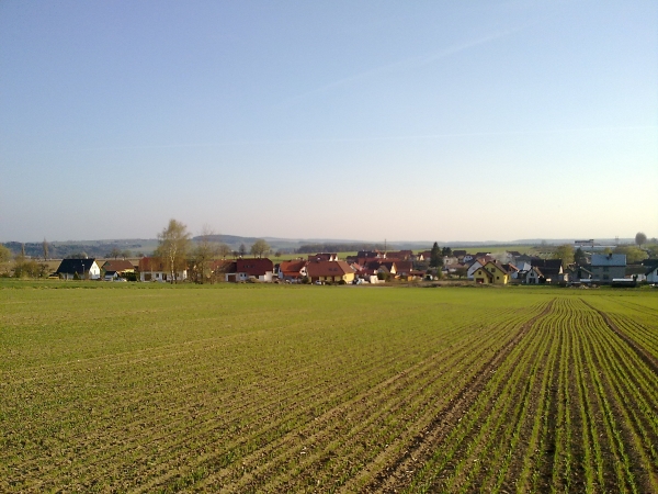
[CZ] Výhled na Velkou Losenici
[EN] View of Velká Losenice

HISTORIE
Obec Velká Losenice byla založena ve 12. stol. Puvodní
obyvatelstvo bylo ceské národnosti, ale práve v této dobe sem byli
privezeni odborníci na težení nerostných surovin. Zvlášte
za dob Premyslovcu a to z nemeckých oblastí jako Horní Sasko a
Durynsko. Težilo se zde hlavne stríbro, také žel. ruda a
to na kopci Peperku. Z pocátku vzniku osady je zrejme i kostel sv.
Jakuba Staršího z doby kolem 12. století. Poté co se vše
„vytežilo“, byli zdejší obyvatelé odkázáni na
zemedelství. Až do konce 16. století byla Velká Losenice pod
správou Polenské farnosti, poté se po schválení knížete
Ditrichsteina osamostatnila.
HISTORY
Village of Great Losenice was founded in the 12th century. The
original inhabitants were Czech, but this is when the experts were
brought here to work, mineral raw materials. Particularly in times
of Premysl and the German regions as Upper Saxony and Thuringia.
Mined are mainly silver, also unfortunately. ore on the hill
Peperku. From the beginning of the settlement is probably the
church. James Elder, of around 12 times century. After everything
is "mined" were local residents depend on agriculture. Until the
late 16th century, the United Losenice Polná under the
administration of the parish, then the approval of the prince
Ditrichsteina independent.
-------------------------------------------------------
GEOLOGIE
Velká Losenice se delí na dve katastrální území (Velká Losenice a
Porežín). Obec leží na okraji CHKO Ždárské vrchy a
nedaleko jsou hranice historických zemí Cech a Moravy zvané Konec
sveta. Obcí protéká Losenický potok, který se po 15 km vlévá do
reky Sázavy. Za zmínku stojí prírodní památka Certuv kámen ci starý
statek s prekrásným výhledem na obec a rozlehlým sadem Bambouch.
Losenicí prochází státní silnice II. trídy, která se po
približne 1,5 km napojuje na silnici I/19. V katastru
leží železnicní stanice Sázava u Ždáru. Vetšinu
z katastrálního území 1490ha zabírají lesy a zemedelská puda.
GEOLOGY
Velká Losenice is divided into two cadastral areas (Velká
Losenice and Porežín). The village lies on the edge of the PLA
Hills and close to the borders of the historical lands of Bohemia
and Moravia called doomsday. Losenicky stream flows through the
commune, which is after 15 km left to the river Sázava. Worth
mentioning is the Devil's natural heritage and old stone farmhouse
with magnificent views over the village and a large orchard
Bambouch. Losenice through the National Road II. class, which,
after approximately 1.5 km road connects to I/19. The land lies at
the railway station Sazava success. Most of the cadastral territory
of 1490 hectares is covered with forests and farmland.
------------------------------------------------------- 
Webové stránky obce zde
O cache:
Keška se nachází v nedalekém lesíku, odkud je pekný výhled
na Velkou Losenici.
Vytvoreno 27.4.2011 by HandyPair