What Is Karst Topography?
Definition: Karst topography is a landscape shaped by the dissolution of a layer or layers of soluble bedrock, usually carbonate rock such as limestone or dolomite.
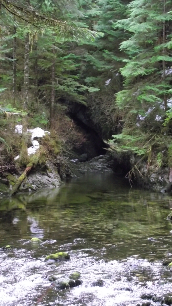
Limestone caves are created through the dissolving of limestone bedrock in the phreatic zone. This happens when slightly acidic river water permeates the voids in the limestone and dissolves passageways through the rock. This weak acidity stems from ambient carbon dioxide (CO2) in the atmosphere that gets captured in rain drops. Sometimes these passages are cavernous enough to walk through and sometimes they are even too small for a mouse. As environmental conditions change, the river may dry up or be redirected, thus leaving passages. However, this river is still flowing strong and no hiker can get in at all.
This river reappears after having been underground for 2 kilometres! Highly trained divers were sent into these narrow passages to inspect every nook and cranny they could. However the passages became too narrow and they only were able to enter about 1 kilometre in.
Jargon
ACTIVE CAVE. n. A cave with a streams flowing in it.
CARBONIC ACID. n. (H2CO3) A weak acid produced when carbon
dioxide, (CO2) is dissolved in water. Usually present in ground water and is responsible for forming caves by dissolution of calcium carbonate rocks.
SPELEOLOGY. n. The exploration, mapping, photography, description and scientific study of caves, subterranean environments and phenomena relating to karst terrains.
STALACTITE. n. A secondary mineral deposit (speleothem), hanging from the roof of a cave and often shaped like an icicle.
STALAGMITE. n. A secondary mineral deposit (speleothem), which grows upward from the floor of a cave.
SUMP. (1) n. A pool of water completely filling a submerged passage as in a water trap. (2) n. The lowest point in part of a cave system, where water collects in a pool before draining or seeping away slowly. cf. cave-pool and lake.
WALK-THROUGH. n. A passage with plenty of headroom where a caver can walk through without stooping or crawling.
Directions
The best way to access this site is from Keogh Main (turn off Highway 19 by the one of the world's largest burls GC1E2JZ . From there it's pretty straight forward using the backroad mapbook until you get to:
Keogh 359 Spur - N 50° 21.321 W 127° 12.892
There are 29 crossditches where the culverts have been pulled out and there is a major washout exactly 1000 metres from the cache so you will have to hoof it and follow the road to the end where you will then see a trail. It's very unlikely you will get a vehicle across not is it likely worth trying and getting stranded. If your vehicle doesn't have clearance, you're looking at a 5km hike/bike ride one way.
Safety and Conservation
As I said, the cave is full of river water so you're not going to get far. Recent funding for signs, boardwalks and guardrails have been provided by a conglomerate of theBritish Columbia Speleological Federation
, the Province of BC, Western Forest Products, and North Island Tourism. The slope down to the mouth has had some ropes put in but the slope is slippery and over the guard rail so there isn't much point in going down.
This is an example of one of the few "visitor friendly" caves on the North Island. There are other systems that are kilometres long and countless more that have been uncharted. The caving groups are understandably secretive about where they are... These caves have the potential to be hazardous without the proper equipment and training.
White Nose Syndrome [PDF]
- White-nose Syndrome (WNS) is a fungal disease that has been associated with mass die-off of hibernating bats in North America. The name refers to a white fungus that grows on the muzzles and bodies of bats found in mass die-offs since 2006. All North American bat species that hibernate are thought to be at risk. It has been discovered in New York, Ontario, and Quebec but not yet in BC. When exploring other caves, keep this in mind that you may be spreading this fungus on your clothes, person, or equipment.
Bear in mind that any limestone formations that you may find in a cave and extremely fragile. Taking any stalactites, stalagmites, etc. is a travesty since these features can take millennia to form. A level of stewardship is expected when spelunking (cave exploring).
To Log This Earthcache
You must E-mail the answers to the following question to me through my geocaching profile. Feel free to log without a reply from me, but if answers are not received within a reasonable amount of time, your log will be deleted.
1.) How many sumps are there between Vanishing River and Reappearing River?
2.) What is "Never Never Land" and where is it located?
3.) How long is sump #5?
4.) Water gets cold after being underground for such a long distance. What is the temperature of the river water? (You can get down to the riverbank safely just downstream from the cave)
5.) Approximately how long is the "canyon" from cave mouth to the "start" of the river? You'll see what I mean when you get there.
