Sandstone views 2 - Eridge Rocks EarthCache
Sandstone views 2 - Eridge Rocks
-
Difficulty:
-

-
Terrain:
-
Size:  (not chosen)
Please note Use of geocaching.com services is subject to the terms and conditions
in our disclaimer.
Sandstone Views
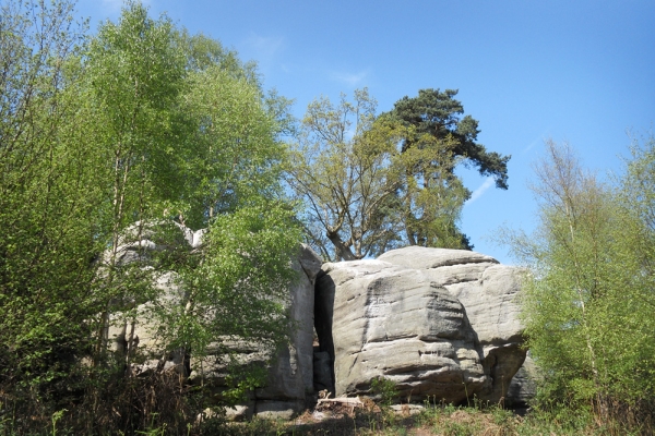
The above coordinates will bring you to this Earth Cache, an impressive and unique Sandstone outcrop stretching for more than 600 metres in the High Weald of East Sussex.
The High Weald is a designated area of Outstanding Natural Beauty and the home to the only Sandstone outcrops in South East England.
This Earth Cache educates and tests your knowledge together with taking you to a very interesting place. Learn about this Sandstone formation and enjoy what you learn and what you see.
There is parking at the location on level ground.
You will find an information board and a spectacular backdrop for you to take photos - No notice board spoilers please !
The foundation for this stunning outcrop of sandstone dates back 140 million years in what is known as the Cretaceous period, it was originally laid down as sandy sediments in the times when Dinosaurs still roamed the planet. These sediments were formed at the bottom of shallow lakes or were carried by rivers and deposited on floodplains.
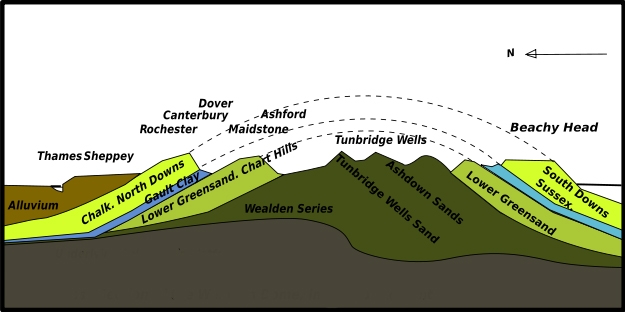
Around 100 million years ago, sea levels rose, and the remains of millions of tiny sea creatures then formed another layer of sediment on top of the sands, this became chalk.
Around 30 million years ago, seismic upheavel began pushing these layers of sediment upwards. Over time, water has eroded most of the softer layers of chalk away revealing these impressive older sandstones, whilst the chalk at the edges has remained and is now what we call the North and South Downs.
Sandstones within the Weald have names such as Ardingly Sand, Ashdown Sand, and Tunbridge Wells Sand, collectively they are known as the Hastings Beds.
This hardest sandstone with steep sided ravines carved out from fast flowing rivers now forms the distinctive Sandstone outcrops of the High weald.
The International importance of the rocks and the plant communities they support means this is a site of Special Scientific Interest and an important Geological Site.
Archaeologists have established Stone Age Man occupied this area for somewhere in the region of 3 thousand years from the Mesolithic to Neolithic times.
In recent times, the rocks were popular with Victorians hosting tea parties complete with servants.
Whilst nobody should ever deface the rocks, the earliest dated inscription is from 1702, where it appears that a lady's dog fell to it's death.
"This scratch I Make that you may know
on this rock lies the beauteous Bow
reader this rock is the Bow's bell
strik't with thy stick and ring his knell"
In order to log this cache mail me via my profile, the answers to the following questions.
All waypoints are on or near the footpath, there is no need for any climbing to complete these tasks.
1. Touch the stone, describe what you feel, describe the colouration, describe the markings.
2. Describe the qualities of the sandstone rock that ensure a perfect climate for the rare plantlife.
3. Go to way point 2, look at the rock face above the opening, describe what you see, would you say this was man made or natural?
4. Go to waypoint 3 look at the rock formation here and describe what you see, how does the appearance differ?.
5. Go to way point 4, standing proud here is Eridge Tower, using your GPS, what is the altitude at this waypoint and what would you estimate to be the height of the tower itself.
As an interesting optional extra, please feel free to post a photo of what you feel is the most interesting part of this rock formation and a brief explanation as to why, if you or your team are in the photo, that would be great! .
No photos of the information sign.
Please e-mail me with the answers as you log the find, no answers within the logs!
I recommend the nearby Sandstone Circular series for a longer walk through this area of outstanding natural beauty, some of the Earth cache waypoints are towards the end of the Sandstone Circular, so plot your route so that you do not have to double back!.
Many thanks to The Sussex Wildlife Trust for allowing the placement of this Earth Cache
Additional Hints
(No hints available.)