
Panorama auf dem Jungfaujoch (oberer Aussichtspunkt, (c) nordie69)
Deutsch
Das Jungfraujoch ist mit 3.471 m über NN der tiefste Punkt im Verbindungsgrat zwischen dem Mönch und der Jungfrau in den Berner Alpen und liegt direkt auf der Grenze zwischen den Schweizer Kantonen Bern und Wallis. Etwa 600 m östlich des Jochs erhebt sich die Sphinx, eine markante kleine Spitze mit einer Höhe von 3571 m. Sie trägt eine Aussichtsplattform und ein wissenschaftliches Observatorium (Sphinx-Observatorium). In ihrem Innern befindet sich auf 3454 m Höhe die Endstation der Jungfraubahn, des höchstgelegenen Bahnhofs Europas. Durch einen Stollen gelangt man von hier aus die Walliser Seite und zum Aletschgletscher. Ein Lift führt auf den Gipfel der Sphinx (www.wikipedia.de).
Das Joch ist weit und stark vergletschert. Aufgrund der starken Erwärmung der Atmosphäre sinkt das Joch jedes Jahr im Schnitt einige ca. 20-40cm ab (www.wikipedia.de).
Das Jungfraujoch ist wegen der hier zu beobachtenden Überschiebung des (kristallinen) Aarmassivs über die nördlich angrenzenden und hochgestauchten Kalkdecken des Mesozoikum geologisch interessant. Der Fuss der Jungfrau ist aus Kristallin, der ganze Vorbau, Schwarzmönch, Rotbrett und Schneehorn, sind aus überlagertem Kalkstein, während in der Gipfelregion Silberhorn, Wengen-Jungfrau und Hauptgipfel aus von Süden überschobenem Magmatit bestehen(www.wikipedia.de).
Im Gebiet der Alpen lag vor 180 Mio Jahren ein flacher Krustensockel (Phase I in Abbildung „Faltung der Alpen“), der zum Teil vom Meer überflutet war. Bis vor 110 Mio Jahren wurde dieser Kontinent auseinander gerissen (Rifting), und tiefe Meereströge entstanden (Phase II in Abbildung „Faltung der Alpen“). Erst seit etwa 100 Mio Jahren wurde im Alpenraum die Kruste zusammengeschoben, und zwischen dem geologischen Afrika und Eurasien entstand das auf einem Drittel der ursprünglichen Breite zusammengestauchte heutige Gebilde der Alpen. das Gebirge ist dabei die sichtbare Erhebung wie auch die tief reichende Wurzel, welches auch in der Abbildung „Geologisches Profil Jungfrau“ gut zu sehen ist (Broschüre „Zwischen Himmel und Erde“, Jungfraubahn, 2010).
Zum Loggen dieses Earthcaches beantwortet bitte folgende Fragen:
- Schaut auch auf die Abbildung weiter unten zum Thema Permafrost an. Könnt ihr erklären, was Permafrost bedeutet?
- Beschreibt die speziellen Konstruktionsmethoden die notwendig sind, um Gebäude und Bahnhof in einer Umgebung mit permafrost sicher im Gestein zu verankern - dies könnt ih rbei genauem Hinschauen aus der Zeichnung erkennen.
- Begebt euch auf der mittleren Ebene aus der Station heraus, dort findet ihr leicht Zugang zu zu einem zugänglichen Felsen. Beschreibt das Gestein (Körnung, Korngröße, Farbe, Kristalle, ...). Erkennt ihr einzelne Kristalle und könnt ihr sagen, um welches Gestein es sich handelt?
- Macht - wenn ihr möchtet (dies ist OPTIONAL) - ein Foto von Euch oder eurem GPS auf dem Gletscher des Jungfraujoch mit der Forschungsstation oder einem anderen Gebäude dort im Hintergrund und fügt dieses dem Logeintrag von euch bei (seid kreativ und flexibel bei dieser Aufgabe)!
Sendet die Antworten per Mail an mein Mail-Account hier bei geocaching.com! Den Logeintrag dürft ihr sofort vornehmen, ich melde mich, wenn etwas nicht stimmen sollte.
Für mich war der Aufenthalt auf dem Jungfraujoch verbunden mit Wanderungen an der Eiger Nordwand sehr beeindruckend - und ich war inzwischen zweimal dort - und ich wünsche euch allen viel Spaß und eine gute und sichere Reise!
Englisch
The Jungfraujoch is a peak with 3.471 m above sea level and the deepest point between the “Mönch” and the “Jungfrau“. There is also a peak called “Sphinx” with a height of 3.571 m above sea level. At this peak there is a scientific station located and. You can go there by elevator and have a really great view outside. Inside the Jungfraujoch there is the highest railway station in Europe with nearly 3.545 m above sea Level, and this place is therefore called “Top of Europe” (www.wikipedia.de).
Around the Jungfraujoch there are a lot of glaciers. Because of the warming of the atmosphere, these glaciers are melting and the Jungfraujoch is going down for about 20-40cm each year (www.wikipedia.de).
At the Jungfraujoch you will find limestone mountains from the Mesozoic and the so called crystalline “Aarmassiv”. The basic rocks from the Jungfrau are also crystalline and the surrounding mountains like the Silberhorn are made out of igneous rock or like the Schwarzmönch, Rotbrett and Schnehorn are made out of limestone (www.wikipedia.de).
At the area of the Alpes, 180 mio years ago, there was some water (phase I, picture “Faltung der Alpen”). This continent was riftet away until 110 mio years ago and some deep areas occurred (phase II, picture “Faltung der Alpen”). Starting 100 mio years ago, this area was pushed together and the mountains in this area were built.
To log this Earthcache, please answer the following questions:
- Take a look at the picture below about permafrost. Please explain this geological phenomenon to me.
- Describe the special construction techniques used to build the station and buildings to keep the permafrost from melting - you could deduce them from this picture, too!
- Go outside the station a the mid-level, where you find some rock outside. Please describe these rock (crystals, grains, grain-size, colour, ...) and are you able to state the name of the rock?
- Please take - if you like, this is OPTIONAL - a photo of you OR your GPS at the glacier with the SPHINX or one of the other buildings in the background and attach it to your logentry. If there is bad wheather, you can take this photo inside the buildings and show something characteristic (just be creative and flexible with this point).
You can make your log entry directly and after doing it, please send the answers here at geocaching.com to my account - I will tell you, if there is something wrong.
There were some real great days at Grindelwald, the Eiger Nordwand and at the "Top of Europe" Jungfraujoch for me and I was there two times. I would like to wish all of you a good day and a safe trip!

Faltung der Alpen (Broschüre "Zwischen Himmel und Erde", Jungfraubahn, 2010)
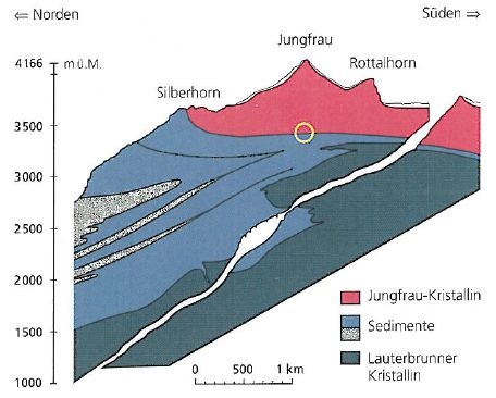
Geologisches Profil Jungfrau (Broschüre "Zwischen Himmel und Erde", Jungfraubahn, 2010)
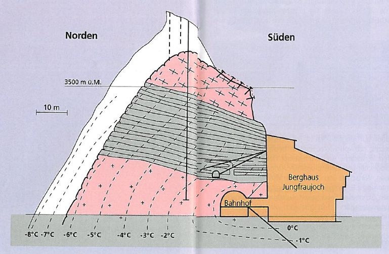
Permafrost am Jungfraujoch (Broschüre "Zwischen Himmel und Erde", Jungfraubahn, 2010)

Stationsplan Jungfraujoch "Top of Europe" (Broschüre "Zwischen Himmel und Erde", Jungfraubahn, 2010)

Free counters