Striated Extrusion of Sacsayhuamán
ENGLISH:
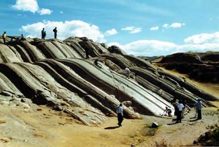
An outcrop of andesite with extraordinary ridged and grooved surfaces face the Inca ruins of Saqsaywamán, near Cusco, Peru. The andesite (volcanic rock named after the Andes mountain range) itself has a fine grain texture. The striations, which range from microgrooves to channels a meter deep, are fairly equal regardless of the direction which they occur. The striated surface is deformed. It is cut by hairline fractures (microjoints), it is broken at angles, and has folded over itself. The andesite with its striated surface has been deformed, both in a stretched and in a brittle fashion, due to a collapse to the side.
The andesite reached this location through an eruptive crack in the Earth's surface. The first materials ejected were hot but solid blocks which built an elongated, steep-sided mound. Later, viscous lava was extruded through the top of the mound and flowed down its sides. The stretching of the lava caused its surface to become striated, similar to the striations on the surface of pulled taffy. The hairline fractures, directional cracks, and folds were produced by the changing conditions of stress during the different stages of the flow. Compaction of the volcanic mound during and after the viscous lava flow caused first a stretched collapse and then brittle collapse of the andesite.
Reference: Geological Society of America
________________________________________
In order to log this Earthcache, complete the following tasks:
1.) What is the elevation at the posted coords?
2.) Find the deepest groove and tell me the estimated depth.
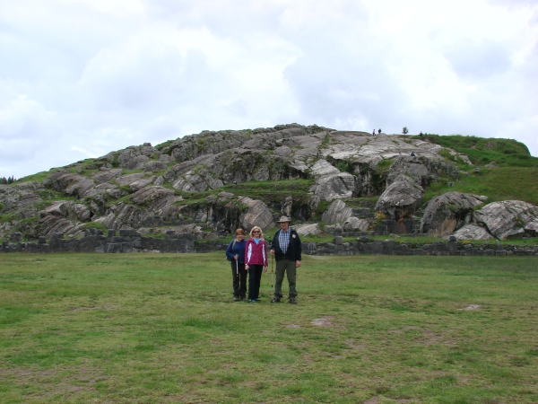
3.) Not required, but it would be nice to post a picture of yourself with your GPS, or just your GPS with any of striated features.
4.) You can log this cache straight away after you have emailed your answers to the cache owner, no need to wait for confirmation.
___________________________________________________________________________
SPANISH:
Los coords fijados le llevarán a la base del afloramiento donde usted encontrará las escaleras para darle el acceso a la tapa. No se olvide disfrutar de la visión mientras que usted está aquí!
Un afloramiento de la andesita con caras superficiales surcadas y acanaladas extraordinarias las ruinas del inca de Saqsaywamán, cerca de Cusco, Perú. La andesita (roca volcánica nombrada después de la gama de montaña de los Andes) tiene una textura del grano fino. Las estriaciones, que se extienden de microgrooves a los canales al metro profundo, son bastante iguales sin importar la dirección que ocurren. La superficie estriada está deformida. Es cortada por las fracturas de la rayita (microjoints), él está quebrada a los ángulos, y se ha plegado sí mismo. La andesita con su superficie estriada ha estado deformida, en una manera estirada y en frágil, debido a derrumbado al lado.
La andesita alcanzó esta localización a través de una grieta eruptiva en el Earth' superficie de s. Los primeros materiales expulsados eran los bloques calientes pero sólidos que construyeron un montón alargado, escarpado-echado a un lado. La lava posterior, viscosa fue sacada a través de la tapa del montón y fluyó abajo de sus lados. El estirar de la lava hizo su superficie llegar a ser estriada, similar a las estriaciones en la superficie del chicloso tirado. Las fracturas de la rayita, las grietas direccionales, y los dobleces fueron producidos por las condiciones de cambio de la tensión durante las diversas etapas del flujo. Compactación del montón volcánico durante y después de que el flujo de lava viscoso causara primero un derrumbamiento estirado y entonces el derrumbamiento frágil de la andesita.
Para registrar este Earthcache, termine las tareas siguientes:
1.) ¿Cuál es la elevación en los coords fijados?
2.) Encuentre el surco más profundo y dígame la profundidad estimada.
3.) No requerido, solamente sería agradable fijar un cuadro de se con su GPS, o apenas su GPS con cualesquiera de características estriadas.
4.)Puede iniciar sesión esta caché inmediatamente después de haber enviado por correo electrónico sus respuestas al propietario caché, no hay necesidad de esperar la confirmación.
___________________________________________________________________________
________________________________________
Congratulations to:
FTF: Chacana, Peru
STF: Wuschel200, Germany
TTF: Shaggz, Austria