[SK]
Sliacske travertiny boli vyhlasene za prirodnu rezervaciu v roku 1983 na ploche 7,02 ha. Prirodna rezervacia lezi na podhori Nizkych Tatier v Liptovskej kotline, v ochrannom pasme Narodneho parku Nizke Tatry. Ich okolie je charakterizovane vyraznymi vyvojmi travertinovych teras a kop, pricom niektore casti uz boli narusene ludskou cinnostou. Prirodna rezervacia predstavuje jedinecny ukaz na uzemi Slovenska.
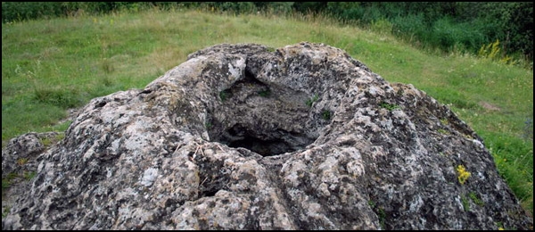
Miesto kde sa nachadzame domaci nazyvaju Teplica. Tu je prave ten spominany jedinecny utvar odborne pomenovany mofetovy pramen. Mofetovy pramen je pramen s pravidelnym, ale rozne intenzivnym vyronom plynov, ktore sposobuju obcasny uhyn drobneho vtactva a inych zivocichov. Uz v roku 1951 bol vyhlaseny v tom case za prirodnu rezervaciu, neskor sa kategoria zmenila na chraneny prirodny vytvor a vznikom prirodnej rezervacie Sliacske travertiny sa stal jej sucastou. Priamo na suradniciach je mohutna travertinova kopa s vyraznym vrcholovym kraterom. V sucasnosti je vdaka neodbornemu zasahu bez vody a je znacne znecisteny odpadom. Vyrony oxidu uhlicnateho v krateri stale pretrvavaju, preto sa v jeho blizkosti treba spravat obozretne a nezostupovat do neho! Podla literarnych udajov mofetovy pramen uz v minulosti pripravil o zivot neopatrnych ludi. Voda pramena ma stalu teplotu 16°C a preto ani pocas zimy potok opustajuci pramen nezamrza. Pramenisko vytvara plochu s rozmermi 300 x 200 metrov so sedimentaciou travertinov v podobe kopy.
Na severnej strane kopy je upraveny pramen mineralnej vody k pitnym ucelom, kde si domaci chodia nabrat vodu do flias. Je to pramen Certovica a sirna voda z neho charakteristicky zapacha. Voda z pramena ma v lete teplotu cca 20°C a vydatnost 81,1 l/min. Obsah CO2 je 1850 mg/liter. Este su tu dva pramene pomenovane Slatina a Na bagrovisku, ktore nie su az tak vydatne, ani nesluzia k pitnym ucelom. Na nive potoka ponize vyveru silne mineralizovaneho pramena sa na znacne inkrustovanej pode sformovala typicka slatinna vegetacia.
Nedaleko je tiez zaujimava lokalita znama ako Kotlisko. Tvori ju plocha travertinova kopa (jama), ktorej priemer je cca 25 metrov, hlbka asi 1,5 m a zabera plochu 70x120 metrov. Nachadza sa nedaleko v udoli nad kraterom, je porastena travou a prilezitostne vyuzivana ako ihrisko.
Nenicte travertiny, pramene ani ine prirodne prvky!
Celym tymto uzemim neprechadza ziadny turisticky ani naucny chodnik, lahko sa sem da dostat autom po asfaltovej ceste.
Pre zalogovanie kesky je potrebne odpovedat na nasledujuce otazky a odpovede poslat na email cez moj profil.
- Popiste vlastnymi slovami aky je to mofetovy pramen.
- Ako vznikaju kratery?
- Na zadanych suradniciach je krater, odhadnite jeho hlbku.
Dobrovolna uloha: Odfotit sa s gps na vrchole kratera a fotku prilozit k logu.
Found it kludne logujte, nemusite cakat na potvrdenie spravnych odpovedi. Ak odpovede budu nespravne alebo neuplne budem vas kontaktovat emailom. Pokial ale vas email nepride do troch dni po logu, log bez upozornenia zmazem!
[EN]
Nature reserve Sliacske travertine was established in 1983 and covers the area of 7.02ha (17.3 acres). This nature reserve is situated in Liptovska hollow basin on the foothill of Low Tatras mountain range – in the protected area of the National Park Low Tatras. Its surroundings are characterized by massive formations of travertine terraces and piles although some parts are already disrupted by the human activities. The nature reserve represents unique phenomenon in the area of Slovakia.
You are at place that is called Teplica by the locals. The mentioned unique formation known in the scientific terminology as a mofetta is visible here. Mofetta is a spring which periodically emits the gas in different intensity which happen to cause perish of small birds or other animals. The spring was declared as nature reserve in 1951, the protection category has changed later to protected nature formation which became the part of Nature reserve Sliacske travertine after its establishment. At coordinates, there is the massive travertine heap with the noticeable crater on the top. Due to an unprofessional damage, the crater is without water in the present and it is being polluted with a litter. The gas outflows persist thus you have to be cautious around it and avoid descending into it! As mentioned by the facts in the literature the mofette spring has killed some incautious people in the past. As the water temperature in the spring is constantly 16°C, its stream does not freeze even in the winter. The dimension of the spring area is 300 meters by 200 meters (984 ft by 656 ft) with travertine sedimentation formed as the pile.
There is a built spring with drink water at the northern side of the pile. The locals use to fill their bottles with the water. The spring is called Certovica and its sulphuric water characteristically smells. The spring water is 20°C warm and gives 81.1 l/min (21.4 gallons/min) in the summer. Carbon dioxide level is 1850 mg/l. There are another two springs called Slatina and Na bagrovisku, which are not so efficient therefore they are not used for drinking. Typical flora of Slatina has grown on highly incrusted soil at the bottomland of the stream below the strongly mineralized stream source.
Another interesting place called Kotlisko is situated nearby. The excavated plane travertine pile with diameter of 25 meters (82ft), 1.5 m (4.9 ft) deep forms Kotlisko and covers the area of 70 meters by 120 meters (230 ft by 394 ft). It is situated nearby in the valley, above the crater; it is overgrown with the grass and it is occasionally used as the playground.
Do not disrupt the travertines, springs or other natural features!
There is neither marked tourist trail nor an educational trail in this area but you can easily access it by the car via the blacktop road.
To claim this cache you need to email me via the link to my profile with the answers of the following questions:
- Describe what is at the mofetta spring.
- How the craters are formed?
- On coordinates given you can see crater. What is its approx. depth?
Optional task: You are welcome to post a photo of yourself or your gps taken at the top of the crater.
Feel free to log this cache. You need not to wait for permission to log. If your answers are not correct or incomplete I will contact you by email. But if I do not receive your email in three days, I will delete your log without a notice!
Thanks to MirecXP for translate.
 The most exciting way to learn about the Earth and its processes is to get into the outdoors and experience it first-hand. Visiting an Earthcache is a great outdoor activity the whole family can enjoy. An Earthcache is a special place that people can visit to learn about a unique geoscience feature or aspect of our Earth. Earthcaches include a set of educational notes and the details about where to find the location (latitude and longitude). Visitors to Earthcaches can see how our planet has been shaped by geological processes, how we manage the resources and how scientists gather evidence to learn about the Earth. To find out more click HERE.