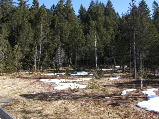
Das Hinterzartener Moor

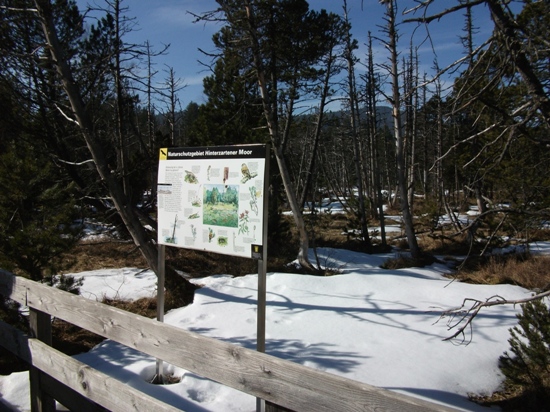
Das Moor ist mit seiner Gesamtfläche das Größte des Schwarzwaldes und gilt als besterhaltenes in Mitteleuropa. Durch einen Holzsteg und Rundwege ist es für alle Besucher gut zugänglich.
Die Entstehung des Moores ist auf die letzte Eiszeit zurückzuführen.
Gletscher des Feldberggebietes schoben Gestein als Moränen in das Gebiet des heutigen Hinterzarten. Das Gestein lagerte sich in Kuppen und Mulden ab. Diese Moränen sind heute nur noch durch Bohrungen nachweisbar (wegen der Dicke der Torfschicht). In einigen Mulden entstanden Tümpel, die durch Torfbildung verlandeten. Torf bildet sich aus Ansammlungen nicht oder nur unvollständig zersetzter pflanzlicher Substanz. Das Hinterzartener Moor lässt sich in zwei Kategorien einteilen. Der westliche Teil ist ein Zwischenmoor und der östliche Teil ein Hochmoor. In beiden Moorbereichen erreicht die Torfschicht stellenweise eine Höhe von 10 Metern.
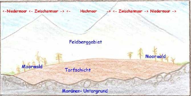
Das Hochmoor ist ein nährstoffarmes (oligotroph) und sauerstoffarmes Gebiet, welches durch Regenwasser gespeist wird. Hochmoore haben durch ihre dicke Torfschicht keine Verbindung zum mineralstoffreichen Boden und zum Grundwasser. Der ph- Wert des Hinterzartener Hochmoorgebietes beträgt 3.5 bis 4.5 (hoher Säuregrad). Als Faustregel gilt: 10cm Torfmoos ergeben, abgestorben und gepreßt ca. 1mm Torf. Das Zwischenmoor ist etwas nährstoffreicher(mesotroph) und besitzt eine bessere Stickstoffversorgung. Es wird teilweise vom mineralstoffreiche Boden und vom Grundwasser gespeist. Die angrenzenden Niedermoore werden längst kultiviert und aufgeforstet. Die unterschiedlichen Nährstoffverhältnisse im Boden der Moorarten führen zu einer spezifischen Flora und Fauna. Zur Vegetation sind auf dem Rundweg, viele Informationstafeln aufgestellt. Bitte die Wege nicht verlassen: Naturschutzgebiet !
(Quellen: eigene Fotos und Skizze, Informationen: vor Ort auf Tafeln, Internet: Wiki- Moore) Broschüre der Bezirksstelle für Naturschutz und Landschaftspflege Freiburg BW(kostenpflichtig) für weitere Informationen zu empfehlen !
Zu den Aufgaben:
1. Wie groß ist das Moorgebiet in ha?
2. Das Moor liegt auf einer Wasserscheide! Welche Bäche werden in östlichen und westlichen Richtung gespeist?
3. Berechne die Wachstumszeit der Torfschicht(siehe Infotafeln) in Jahren ! Wie alt ist das Moor?
4. Von wem bekommen Fliegen im Hochmoor manchmal eine geklebt?
5. Erkläre den Begriff Moräne (das Fundament des Hinterzartener Moores) kurz und knapp ?(Info Internet)
6. Optional: Ein Foto von Euch oder dem Gps an der Infotafel auf dem Steg wäre schön.
Bitte die Antworten nicht im Log erwähnen. Die Aufgaben 1-4 sind vor Ort zu lösen, Aufgabe 5 via Internet . Du kannst sofort loggen, aber sende die Antworten bitte über mein Profil: " send message" an mich. Sollte es Probleme geben, melde ich mich. Falsche Logs werden von mir gelöscht.

english version
The moor is the largest of its total area of the Black Forest and is considered the best preserved in Central Europe. By a wooden bridge and trails, it is easily accessible for all visitors.
The formation of the moor is the result of the last ice age. Glacier Mountain area of the field pushed rock as moraines in the area now Hinterzarten. The rock was deposited in peaks and troughs. These moraines are now only detectable through drilling holes (because of the thickness of the peat layer).
In some wells were pools that silted up by peat. Peat is formed from accumulations not or only partially decomposed plant matter.
The Hinterzarten moor can be divided into two categories. The western part is an intermediate moor and the eastern part of a „Hochmoor“. In both areas, the peat moor in places reaches a height of 10 meters. The moor is a nutrient-poor (oligotrophic) and oxygen-poor area, which is fed by rain water. Through their thick layer of peat not connect to the mineral-rich soil and groundwater. The pH of the moor area is 3,5 to 4,5 (high acidity). As a rule: 10cm peat moss, dead and forced about 1 mm peat. The intermediate marsh is slightly more nutritious (mesotrophic) and has a better supply of nitrogen. It is fed in part by the mineral-rich soil and the groundwater. The area around the moor has long been cultivated and planted.
The different nutrient conditions in the bottom of the wetland species leads to a specific flora and fauna. To vegetation on the trail, set up many information boards. Please do not leave the way: Nature Reserve!
Sources: own photos and sketches, information: on the spot on boards, Internet: Wiki - Moore booklet of the District Office for Nature Conservation and Landscape Freiburg BW (cost) recommended for more information!
To the questions:
1. How big is the moor area in hectares?
2. The moor is on a watershed! Which rivers are fed into eastern and western direction?
3. Calculate the growing time of the bog (see information boards) in years!
4. Which plant cache the fly in summer?
5. Explain the term moraine (the basis of Hinterzartener Moor) in a short sentence? (Internet Information)
6. Optional: A photo of yourself or your GPS at the information board would be nice!
1-4 see Infoboard! 5 see Internet!Please do not write the answers into the online log, thanks! You can log in immediately, but please send the answers on my profile: "send Message" to me. If something is wrong, I contact you. I will delete logs with wrong answers.
