Vorwort
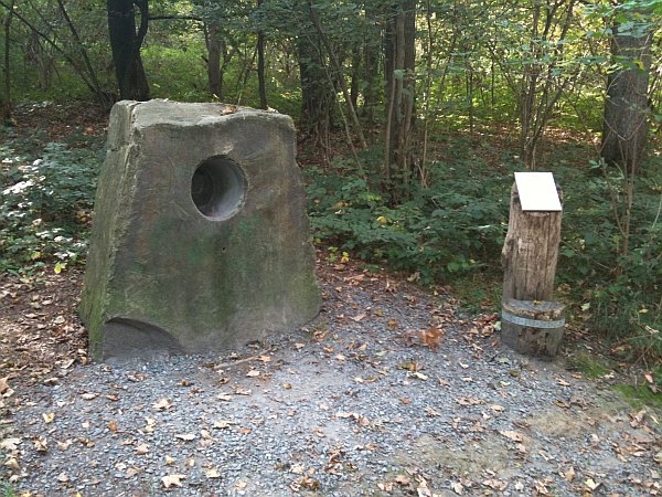
Summstein auf dem Nümbrechter Klangpfad. Wer ein bischen Zeit mitbringt, sollte sich ruhig auch einmal den kompletten Klangpfad anschauen.
Einleitung
Dieser Earthcache in Form eines Summsteins befindet sich im Wald von Schloss Homburg in Nümbrecht und bildet eine Station des dort verlaufenden Klangpfades.
* Summsteine im Allgemeinen
Ein Summstein ist ein Stein mit einer Aushöhlung, dem sogenannten „Summloch“. Mit dem in der Höhlung befindlichen Kopf erzeugt man einen Summton, in dem man tief summend ausatmet. Die Töne geraten in Resonanz und erzeugen dadurch Vibrationen, die den ganzen Körper erfassen und innen und außen wahrnehmbar sind. Je nach Tonlage löst dies ein stärkeres oder schwächeres Kribbeln im Körper aus, dem wie einst in den Höhlen von Syrakus eine wohltuende, heilsame und meditative Wirkung zugeschrieben wird. Summsteine werden heute in Anlagen zur Förderung der Sinneswahrnehmung aufgestellt.
* Der Nümbrechter Summstein im Speziellen
Es handelt sich hier um einen Grauwackestein, der aus dem Steinbruch Jäger im Oberbergischen Wildbergerhütte stammt.
Grauwacke ist ein Begriff aus der Bergmannssprache des Harzes. Er bezeichnet graue bis grüngraue Sandsteine mit Anteilen an Gesteinstrümmern von z.B. Quarzit, Phyllit, Tonschiefer usw. Der Begriff wird meist nur für Gesteine verwendet, die dem Paläozoikum entstammen oder noch älter sind.
** Abgrenzung
Die Verwendung ist seit mindestens 1780 belegt. Wacke ist hierbei ein veralteter Name für Wackersteine.
In Deutschland ist ‚Grauwacke‘ darüber hinaus ein veralteter stratigraphischer Name für Gesteine des Unterkarbons der Kulmfazies. Grauwacken finden sich in Mitteleuropa zum Beispiel in den alten Rumpfgebirgen (etwa im Harz oder im Rheinischen und Thüringischen Schiefergebirge). Etwa gleich alte Grauwacken treten in den Alpen als schmaler Streifen nördlich der Zentralalpen zu Tage (Grauwackenzone).
Gemäß Vinx (2005) wird ‚Grauwacke‘ heute lediglich als Gesteinsbenennung im Gelände verwendet. Die korrekte Bezeichnung eines entsprechenden Gesteins wäre Litharenit.
** Entstehung
Grauwacken sind marine, klastische Sedimente, die bevorzugt im Umfeld der Entstehung und Abtragung von Gebirgen abgelagert werden. Sie haben ein oft ausgedehntes Liefergebiet, aus dem das Ausgangsmaterial der Grauwacken zum Meer transportiert wird und als küstennahe Sedimentmasse abgelagert wird. Durch Instabilitäten können die noch nicht verfestigten Ablagerungen in ihrer Lagerung zu fließen beginnen und einen Trübestrom erzeugen, mit dem das Material über weite Strecken transportiert werden kann. Kommt der Strom zum Erliegen, werden größere Gesteinsfragmente zuunterst gelagert, während kleinere Fragmente langsam absinken. Dies erzeugt eine gradierte Schichtung im Vertikalschnitt. Das entstehende Gestein wird als Turbidit bezeichnet; es ist das typische Gestein einer Flyschablagerung.
** Zusammensetzung
Die relativ weichen, meist dunklen Gesteine stellen eine Klasse von Sandsteinen dar, die aus Quarz, Feldspat (meist Plagioklas), Kiesel- bzw. Tonschiefern und Gesteinsbruchstücken in einer tonigen Grundmasse (Matrix) bestehen. Der Matrixanteil des Gesteins beträgt dabei mehr als 15 %, besteht meist aus Tonmineralen, Chloriten und Glimmern und verursacht die meist dunkel(grün)graue Färbung. Grauwacken sind mittel- bis feinkörnig, teilweise auch grobkörnig, stark verfestigt, schlecht sortiert und gerundet, oft gradiert und fein laminiert.
Nach H. G. Huckenholz (1963) bestehen Grauwacken aus:
- 28 - 53 % Quarz
- 25 - 47 % Feldspat
- 4 - 21 % Glimmer
- 4 - 25 % Chlorit
- 0 - 6 % Karbonaten
- 1 - 3 % akzessorischen Mineralen
Grauwacken lassen sich unterscheiden in Quarzwacken (dominierender Quarzgehalt), Feldspatwacken (Quarz, Feldspat und geringe Mengen an Gesteinsbruchstücken) und lithische Wacken mit einem hohen Anteil von Gesteinsbruchstücken.
--- Quelle: www.wikipedia.de
Die Aufgabe
Ein Foto von euch in origineller Pose vor, bzw. mit dem Kopf im Stein, wäre natürlich super, ist aber selbstverständlich kein Muss.
Um die Logfreigabe zu erhalten, gilt es zunächst die folgenden Aufgaben zu lösen:
- Da der Stein relativ geometrisch geformt ist, wäre es doch mal interessant das ungefähre Gewicht in Tonnen zu berechnen, welches der Stein zu der Zeit besessen hat, bevor man dort das Summloch hineingebohrt hat. Verwendet bitte für die benötigten Messungen möglichst die Vorder- sowie die Oberseite des Steines. Für Grauwacke gilt desweiteren eine Rohdichte von 2,57 g/cm³. Für die Lösung reicht die Angabe mit 1 Nachkommastelle (Beispiel: 0,5t / 1,7t / 2,9t / usw.).
- Natürlich wollen wir das Summloch an dieser Stelle nicht komplett vernachläßigen. Daher berechnet doch als zweites einmal, um wieviel kg in etwa der Stein leichter geworden ist, nachdem man das Summloch hineingebohrt hat. Da es sich bei dem Loch ebenfalls um eine markante geometrische Form handelt, sollte dies relativ einfach machbar sein. Hier bitte auf volle 5er runden (Beispiel: 5kg / 10kg / 15kg / usw.). Bitte beachten: Ihr müsst nur bis zur ersten Kante im Inneren messen, die etwas kleinere Aussparung im Hintergrund kann vernachläßigt werden.
- Je länger dieser Stein dort stehen wird, desto mehr wird man daran Zeichen der Verwitterung erkennen können. Grundsätzlich unterteilt man die Einflüsse für Verwitterungen in 3 Hauptgruppen. Nennt bitte sowohl die 3 Gruppen, als auch jeweils ein Beispiel für jede Gruppe.
- Wenn ihr euch den Stein dann einmal etwas näher anschaut, prüft doch mal, ob sich bereits Spuren der Verwitterung dort wiederfinden und welche dies ggfs. sein könnten.
Die Lösung schreibt ihr dann einfach incl. der verwendeten Formeln, sowie der einzelnen Formelwerte als Nachricht an mich. Ihr dürft dann sofort loggen. Sollte etwas nicht stimmen melde ich mich.
Zum Cache
Ihr müsst die in der Nähe befindliche Hauptstraße nicht betreten, um zu dem Stein zu gelangen. Bleibt immer auf den Waldwegen.
Grundsätzlich kommt man mit dem Rollstuhl bis an den Stein heran. Der Waldweg kann allerdings stellenweise schon mal etwas steiler sein.
Der Empfang da oben ist leider ziemlich grausig, so dass es durchaus sein kann, dass die Koordinaten etwas off sind.
Wenn ihr aber immer auf den Wegen bleibt, könnt ihr den Summstein nicht verfehlen.
Preface
Humming Stone located along the Nümbrecht "Sound-Path". If you have a little extra time I'd recommend you walk the whole path. It's quite interesting.
Introduction
This Earth cache in the form of a humming stone is located in the forest around Homburg Castle in Nümbrecht and forms a station of the sound path running alongside it.
* About Humming Stones in general
A humming stone is a stone with a cavity, the so-called "Summloch. Locate your head in the hollow to generate a buzz, by breathes deep humming. The tones come into resonance and thereby generate vibrations which cover the whole body and are discernible inside and outside. Depending on the pitch this triggers a stronger or weaker prickle in the body to which like once in the caves of Syracuse a wholesome, healing and meditative effect is ascribed. Today Humming stone are placed in facilities for promotion of sensory perception.
* Details about this stone in particular
The stone is made of Greywacke. Greywacke or Graywacke (German Grauwacke, signifying a grey, earthy rock) is a variety of sandstone generally characterized by its hardness, dark color, and poorly sorted angular grains of quartz, feldspar, and small rock fragments or lithic fragments set in a compact, clay-fine matrix. It is a texturally immature sedimentary rock generally found in Palaeozoic strata. The larger grains can be sand- to gravel-sized, and matrix materials generally constitute more than 15% of the rock by volume. The term "greywacke" can be confusing, since it can refer to either the immature (rock fragment) aspect of the rock or the fine-grained (clay) component of the rock.
The origin of greywacke was problematic until turbidity currents and turbidites were understood, since, according to the normal laws of sedimentation, gravel, sand and mud should not be laid down together. Geologists now attribute its formation to submarine avalanches or strong turbidity currents. These actions churn sediment and cause mixed-sediment slurries, in which the rocks may exhibit a variety of sedimentary features. Supporting the turbidity current origin theory is that deposits of greywacke are found on the edges of the continental shelves, at the bottoms of oceanic trenches, and at the bases of mountain formational areas. They also occur in association with black shales of deep sea origin.
Greywackes are mostly grey, brown, yellow or black, dull-colored sandy rocks which may occur in thick or thin beds along with slates and limestones. They are abundant in Wales, the south of Scotland, the Longford Massif in Ireland and the Lake District National Park of England; they compose the majority of the main alps that make up the back bone of New Zealand. They can contain a very great variety of minerals, the principal ones being quartz, orthoclase and plagioclase feldspars, calcite, iron oxides and graphitic, carbonaceous matters, together with (in the coarser kinds) fragments of such rocks as felsite, chert, slate, gneiss, various schists, and quartzite. Among other minerals found in them are biotite, chlorite, tourmaline, epidote, apatite, garnet, hornblende, augite, sphene and pyrites. The cementing material may be siliceous or argillaceous and is sometimes calcareous.
As a rule greywackes are not fossiliferous, but organic remains may be common in the finer beds associated with them. Their component particles are usually not very rounded or polished, and the rocks have often been considerably indurated by recrystallization, such as the introduction of interstitial silica. In some districts the greywackes are cleaved, but they show phenomena of this kind much less perfectly than the slates. Some varieties include feldspathic greywacke, which is rich in feldspar, and lithic greywacke, which is rich in tiny rock fragments.
Although the group is so diverse that it is difficult to characterize mineralogically, it has a well-established place in petrographical classifications because these peculiar composite arenaceous deposits are very frequent among Silurian and Cambrian rocks, and are less common in Mesozoic or Cenozoic strata.[citation needed] Their essential features are their gritty character and their complex composition. By increasing metamorphism, greywackes frequently pass into mica-schists, chloritic schists and sedimentary gneisses.
--- Source: www.wikipedia.de
How to log this Earthcache
A photo of you in an original pose in front of, or with the head in the stone, would be great, but is not necessary to log this Earthcache.
To log this Earthcache, just figure out the following:
- Since the stone is relatively geometrically shaped, it would be interesting to calculate it's approximate weight in tons, at the time, before the "Humming Hole" has been drilled. Please use the front side and the top side of the stone for the required measurements. For Greywacke please use the density of 2.57g per cm³. For the solution it is sufficient to state with one decimal place (Example: 0,5 t / 1,7 t / 2,9 t / etc.).
- Of course we do not want to neglect the "Humming Hole" at this point completely. Therefore please calculate how much weight in kg the stone has lost after the "Humming Hole" has been drilled into it. Since the hole represents a well known geometric form as well, this should be relatively easy to complete. For the solution it is sufficient to state in steps of 5 (Example: 5kg / 10kg / 15kg /, etc.)
- The longer this stone's going to be there, the more you will be able to recognize signs of weathering. Basically, one divides the influences of weathering in three main groups. Please write down all these groups, as well as one example for each group.
- If you take a closer look at the stone you can also check if you can already find traces of weathering there and which that might be.
Next send me a message containing your solutions including the formulas you used together with all the values. You can log immediately. If there's something wrong with your answers I'll contact you.
About this Cache
You don't need to walk on the main street. Always stay on the forest paths.
You can reach the stone by wheel chair. However please note: The path can be a little bit steep sometimes !
The Coordinates might be a little bit off. So just stay on the Path and you can't miss the stone.