Welcome to Tom S. Cooperrider-Kent Bog State Nature Preserve, a living relict from the Ice Age.
Walking through this preserve is like stepping back 10,000 years in time, a remarkable and timeless place. The landscape found here is more commonly found hundreds of miles north of Ohio. Eventually, the bog will disappear as did the glacier that created it. Yet today and for generations to come, it will remain a part of our living natural heritage to protect, study, and enjoy.
History of the Nature Preserve
In 1985, the Division of Natural Areas and Preserves purchased this area in Portage County, just south of Kent and west of S.R. 43. It was the first state nature preserve purchased with funds donated by the citizens of Ohio through the Ohio Income Tax Refund Checkoff Program.
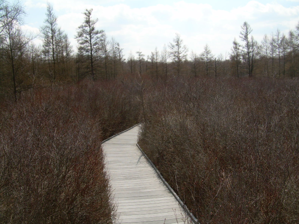
In 1993, a half-mile, wheelchair-accessible boardwalk was built in Kent Bog with the support of ODNR’s Division of Recycling and Litter Prevention. Not only has it made this unique preserve accessible to all visitors, but the recycled plastic lumber boardwalk demonstrates the utility of using recycled-content materials. The boardwalk meets all requirements of the Americans with Disabilities Act.
Formation of the Bog
For thousands of years, northeast Ohio lay buried beneath a thick mantle of ice, called the Wisconsinan Glacier, hundreds of feet thick and the last one to be here. Approximately 12,000 years ago, it began to melt and retreat northwards towards the North Pole. In its wake it created many rivers and lakes.
A piece of that glacier actually broke off the main sheet and settled here. It was soon buried under massive amounts of debris washing out of the glacier. Eventually that ice block completely melted under the debris and the resulting depression filled with water. Thus, a deep, 50-acre kettle hole lake formed.
All lakes tend to fill with sediments over time and ultimately cease being lakes. Here, shoreline bog plants encroached upon the center of the lake, building up and filling the lake with peat. Peat is the name given to poorly or partially decomposed organic matter. It is formed when bacteria and fungi, the principal decomposers of organic matter, cease to function under conditions of excessive wetness and low oxygen.
The open water of the lake gave way to the (floating) bog mat we see today. The mat is comprised primarily of peat land shrubs and trees situated on a lush carpet of living sphagnum moss. This moss continually grows from the top while dying back at the bottom. Large amounts of humic acids are released as dead spahnum tissue breaks down, this greatly acidifies the bog environment. The last vestige of open lake here probably disappeared just prior to European settlement
The Lagg
Excessive shade and leaf litter from adjacent upland trees and seasonal flooding by mineral-enriched, well-oxygenated run-off from adjacent slopes have essentially eliminated peat production around the perimeter of the bog. The result is the presence of a moat which allows for the invasion of wetland species more typical of this part of Ohio. Almost all bogs have such moats and are known as laggs, a term of Swedish origin.
You’ll notice some tree cutting going on in the bog towards the end of your walk, nearer the lagg. DNR is cutting down some maples that have gotten a foot hold in the bog. This is their way of slowing down the conversion of this bog to ‘normal’ ground.
Unique about this bog
Kent Bog supports the largest and southernmost stand of tamarack trees in the continental United States. This is due to the unusual environmental conditions present in the bog; cold and wet (swampy) year round, just like it was back in glacial times. Tamaracks thrive in those conditions. There are more than 3,500 tamarack trees in the preserve, with many robust seedlings growing among the older and larger trees. Interestingly, I have a tamarack tree growing in the backyard of my house in Akron. Didn’t know what kind of tree it was until I discovered this bog while finding the virtual geocache here years ago. My tree stands 60 feet tall and I can barely get my arms around the trunk. I’m guessing it was planted when the house was built in 1948. Don’t like the tree much, being a deciduous tree it loses its needles (no leaves) every fall. Those needles cover everything in my backyard and get all into my weather-stripping of my cars. Grrrr…
Visiting Info
Entrance to the preserve is off of Meloy Road, just west off of Route 43.
Open daily from one-half hour before sunrise to one-half hour after sunset throughout the year. If the gate is closed, please park in the space provided outside, leaving room for emergency access. No bathroom on site.
Pets are NOT allowed in ODNR Preserves unlike State parks. Please DO NOT not bring your 4 legged friends here, too sensitive of an area.
Please help protect this special place by observing the rules and regulations posted near the entrance. Please hike only on the boardwalk. Practice Cache In Trash Out. Follow Leave No Trace recommendations. Take only pictures & leave only memories.
Dedicated state nature preserves represent the finest examples of Ohio’s natural features. Public visitation is encouraged but is closely regulated to protect the natural integrity of the preserves for future generations
To log this Earthcache
You Must post a picture of yourself or a personal item somewhere along the boardwalk. You chose the location on the boardwalk. (As explained in Earthcache Logging Tasks 4.3.)
Walk the half-mile boardwalk and answer these questions. ALL answers are found using the numerous waysides (info signs) along the boardwalk here. Take notes and email your answers to me through my profile, let me know if you are providing answers for a group of cachers who visit the same day.
1. The debris that covered that block of ice, that formed this bog, was made up of what three materials?
2. The Sphagnum moss releasing the humic acid into the bog has created a pH level of what in the bog?
3. How did Native American moms & dads use the sphagnum moss found here?
4. What time of year does the lagg dry up temporarily?
5. What is the purpose of the white PVC pipes found under the boardwalk?
6. While hiking the boardwalk in the full circle, how many times did you cross over the lagg?
Failure to answer the question will result in your log deletion without notice. Per Earthcaching policy, you have 5 days to do so after logging your visit.
Thanks to the Ohio Department of Natural Resources and permission granted for this Earthcache by Charlotte McCurdy, the Northeast District Preserve Manager.
References
Onilne at Ohio DNR website -- Kent Bog
The multiple waysides along the boardwalk here
Be sure to grab the Virtual Geocache while here-- 2 Little Known Gems: Kent/Cooperridder Bog
 This is the hiking viking's 125th cache in the greater Akron area.