Old Jersey EarthCache
-
Difficulty:
-

-
Terrain:
-

Size:  (other)
Please note Use of geocaching.com services is subject to the terms and conditions
in our disclaimer.
A simple but interesting bit of geology and its history on the
region.
This earthcache can be viewed from the Carteret Waterfront/
Veteran's Park.
Many people would not consider viewing the Arthur Kill as something
with geologic significance. Some research into this channel
suggests otherwise.
The Arthur Kill is approximately 10 miles long and connects Raritan
Bay on its south end with Newark Bay on the north. Along the New
Jersey side it is primarily lined with industrial sites. The Staten
Island side is primarily lined with salt marshes.
Because of the complex nature of the tides in New York-New Jersey
Harbor Estuary near the mouth of the Hudson River, the hydrology of
the Arthur Kill is still an open subject. In particular, the net
flow of the channel is not well established. This means that the
water may be flowing south towards the Raritan Bay, or north
towards Newark. What do your observations tell you about the flow?
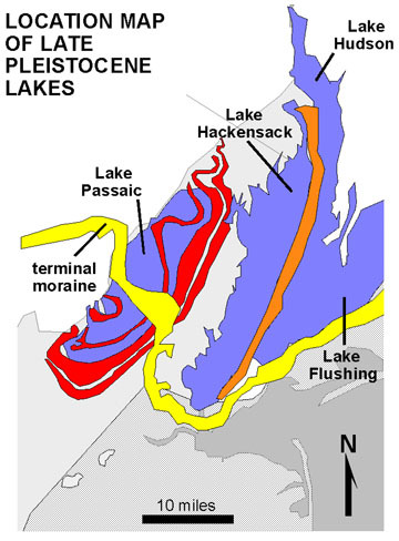
Consider the map shown here. With the rising and falling of the
Atlantic Tide entering and exiting all sides of Staten Island, as
well as the southerly flow of the Hudson River, it is no wonder the
net flow of the AK is undetermined.
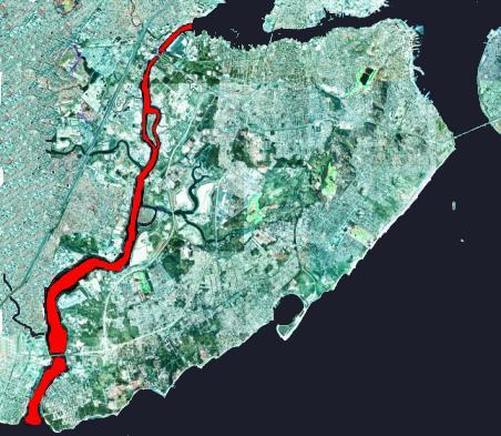
There are two small uninhabited islands in the channel. The Isle of
Meadows is right in front of you slightly to the north. You are
looking at the Great Fresh Kills, around the southern end of the
island. It empties the Fresh Kills Water basin into the Arthur
Kill. ,Your overall view to the east reveals Staten Island, and its
salt marshes.
The Arthur Kill was carved by an ancestral phase of the Hudson
River resulting from the blockage of the main channel of the Hudson
at the Narrows by moraine or an ice dam during the Wisconsin
Glacial Period. This glacier formed much of what we see around the
region today.
The size of the Arthur Kill channel is large, suggesting that it
was, for a time, the primary drainage from the region. However, it
could not have been a primary drainage for long because the river
did not have enough time to carve a broad flood plain. The outflow
resulted in the separation of Staten Island from New Jersey. I
guess Staten Island could be called Old New Jersey in some
respects.
The name "Kill" comes from an old Dutch term for stream or
river. The Kill Van Kull is a different tidal strait, on the North side of Staten Island, South of Bayone.
To log this earthcache,
1. Post a photo of yourself with your GPSr with the Arthur Kill in
view. (optional)
2. Post a description of your observation of the water flow in the
main body of the channel? North? South? Undetermined?
3. Observe the coastline surrounding the promenade on which you are
standing. Observe the coastline of The Isle of Meadows. You can
choose to use binoculars or the coin operated viewer on the deck if
you like. Can you determine the tidal height difference in the
exposed rocks and soil? Identify if you are visiting at high tide,
low tide, and the time of day.
4. What is the direction of water flow around the marshes on The
Isle of Meadows? Do you observe any changes in color or clarity
where the fresh water of the Fresh Kills meets the saline mixture
of the Arthur Kill? Are there swirls or eddys visible in the
channel here? Describe.
Additional Hints
(No hints available.)