
 As
you embark or continue your journey to discover and explore
beautiful and historic rocks, waterfalls, peaks, creeks and other
wonders, please keep in mind that these places need to remain wild
and protected so that they may be enjoyed by others for generations
to come. Please be diligent in respecting these sites by doing the
following:
As
you embark or continue your journey to discover and explore
beautiful and historic rocks, waterfalls, peaks, creeks and other
wonders, please keep in mind that these places need to remain wild
and protected so that they may be enjoyed by others for generations
to come. Please be diligent in respecting these sites by doing the
following:
- Please keep trash with you at all times, do not leave it behind
in these pristine places.
- Bury human waste 6 inches deep, make certain you are at least
50 paces away from any water source and PLEASE bring your toilet
paper and sanitary items back out with you.
- Keep food and all scented items on your person at all
times.
- Support wildlife by allowing them to find their own food, do
not feed them.
- Allow plants to grow and water to stay clean by staying on
trails, bike paths and roads.
Thank you, Yosemite Wilderness Management
To complete this EarthCache, you will need to visit at least
three waypoints that are a couple miles apart. All the locations
are on paved paths or roads and are within walking distance of
shuttle stops. Measurements with your gps, timer, and sticks will
be needed.
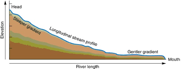
The typical profile of a river begins in mountainous areas with
relatively steep channels progressing to a more gently sloped
channel as the river reaches its base level. Base
level is the lowest point a river flows. Ultimately this is sea
level, but local or temporary base levels occur along rivers where
water is naturally or artificially dammed. For the Merced River,
the El Capitan Moraine (See EarthCache) created a natural dam in
Yosemite Valley and a local base level.
(Fluvial Landscapes )
Generalizations about river geomorphology have been developed.
These generalizations are shown in the graphs and diagram below.
Three points along a typical river are shown. Location
‘A’ is up on the side of the mountain near the source
of the river. Location ‘B’ is about midway between the
source and mouth of the river. And location ‘C’ is near
the mouth or base level of the river.
Each graph relates an attribute of the river to discharge.
Discharge is the volume of water flowing through the river at each
point. Discharge increases from mountain streams (point
‘A’) to rivers (point ‘C’) because multiple
mountain streams join together to form a single river. In order to
accommodate the additional water, the width, depth, and velocity of
the channel increases from ‘A’ to ‘B’ to
‘C’. However, the gradient of the channel
decreases.
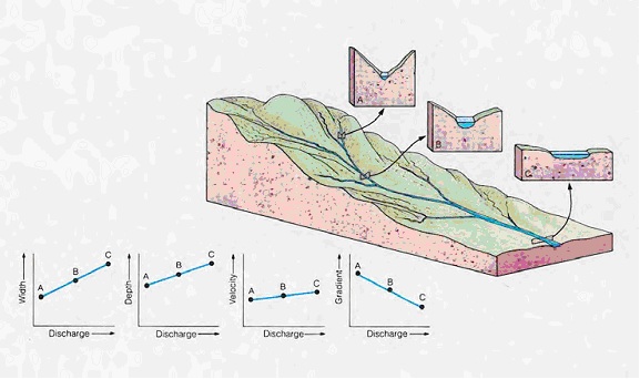
The shape if the river canyon at each point is also in the
diagram. Mountain streams are usually in steep walled, narrow
canyons. In between the headwaters and mouth, Point
‘B’, the river canyon widens out a bit, and near the
mouth, the river occupies a wide flat flood plain.
For this EarthCache, you will look at each of these
characteristics, width, depth, velocity, and gradient, at the three
waypoints along the Merced River and see if the river follows this
pattern.
- Waypoint 1: N37 43.953 W119 33.518
- Waypoint 2 : N37 44.375 W119 33.877
- Waypoint 3 : N37 44.647 W119 34.194
- Bonus : N37 43.031 W119 39.723
Follow the instructions to get each:
- Width – mark a waypoint on one side of the river, walk to
the other side and find the distance with your GPS.
- Depth – Drop a weighted rope or string into the water
from a bridge at the deepest point of the channel.
- Velocity – using your GPS, measure off 100 feet along the
river. Toss a stick into the water at the start, time how long it
takes to go the 100 feet. Divide the 100 feet by the time in
seconds to get feet/second.
- Gradient – Using your altimeter on your GPS, determine
the altitude at the river bank (don’t get near the water if
it is dangerous, just use the riverbank) 100 feet apart along the
flow of the river. Divide the elevation difference by 100 feet to
get a ratio of feet/feet.
- Valley shape – Estimate based on your observations
Logging questions:
- The text "GC2M37Q River Geomorphology of the Merced River" on
the first line
- The number of people in your group.
- The readings you got from each waypoint?
- Does the Merced River match the general description of river
geomorphology, what would account for any differences or
similarities?
The following sources were used to generate this
cache:
- Matthes, Francois. 1930 USGS. Geological Survey
Professional Paper 160 Geologic History of the Yosemite Valley.
http://www.nps.gov/history/history/online_books/geology/publications/pp/160/index.htm
Last Updated: 28-Nov-2006
- Kiver, Eugene and David Harris. 1999. Geology
of U.S. Parklands Fifth Edition, John Wiley & Sons,
Inc.
- Fluvial Landscapes
http://www.slideshare.net/wskirkham/fluvial-geomorphology
- Knight, Kim, Planet Earth EPS 50 – Spring
2006 Rivers and Streams Lecture, University of California Berkley,
http://eps.berkeley.edu/courses/eps50/documents/lecture24.rivers.pdf